Melbourne tram route 75
| Route 75 | |||||
|---|---|---|---|---|---|
| Central Pier Docklands – Vermont South | |||||
 | |||||
_in_Flinders_St_on_route_75%2C_February_2009.jpg) B class tram on Flinders Street in February 2009 | |||||
| Overview | |||||
| System | Melbourne | ||||
| Operator | Yarra Trams | ||||
| Depot | Camberwell | ||||
| Vehicle |
A class B class | ||||
| Night-time | Friday & Saturday | ||||
| Route | |||||
| Locale | Melbourne, Australia | ||||
| Start | Central Pier Docklands | ||||
| Via |
Flinders Street Richmond Hawthorn Camberwell Burwood | ||||
| End | Vermont South | ||||
| Length | 22.8 km (14.2 mi) | ||||
| Zone(s) |
Free Zone: Stops D2-D6, 1-8 Myki Zone 1: Stops 9-40 Myki Zone 2: Stops 41-75 | ||||
| Annual patronage | 9.3 million | ||||
| Timetable | Route 75 timetable | ||||
| Map | Route 75 map | ||||
| |||||
Melbourne tram route 75 is operated by Yarra Trams on the Melbourne tram network. It operates from Central Pier Docklands to Vermont South.
Unlike most Melbourne tram routes, route 75 operates in both Myki zones 1 and 2. The 22.8 kilometre route is operated by A and B class trams from Camberwell depot.[1][2]
History

The origins of route 75 lie in separate tram lines, Australia's first cable tram from Bourke Street to Hawthorn Bridge and a horse tram from Hawthorn Bridge to Auburn Road, which was converted to an electric line and extended over many years to its current terminus at Vermont South.
The first cable tram line opened by the Melbourne Tramway and Omnibus Company was from Bourke Street to Hawthorn Bridge along Spencer Street, Flinders Street, Wellington Parade and Bridge Road opened on 11 November 1885.[3][4] On 27 January 1889 a horse tram from Hawthorn Bridge to Auburn Road, travelling Burwood Road, Power Street and Riversdale Road was opened.
The Hawthorn Tramways Trust closed the horse tramway for conversion to electric traction on 31 January 1916, with the electric line opening in two stages; Power Street to Auburn Road along Riversdale Road opening on 7 May 1916, and from Hawthorn Bridge to Riversdale Road along Burwood Road and Power Street on 21 June 1916. The Riversdale Road line was extended by the Hawthorn Tramways Trust to Bowen Street, Camberwell along Riversdale Road and Camberwell Road, passing through Camberwell Junction, opening on 31 May 1916, it was extended again to Boundary Road (now Warrigal Road) along Camberwell Road and Norwood Road (now Toorak Road) on 10 June 1916.[5]
The Melbourne & Metropolitan Tramways Board converted the Bourke Street to Hawthorn Bridge cable line to electric traction in three stages, closing the line on 29 June 1927. Reopening with electric trams running from Lonsdale Street – a short electric extension to the previous cable terminus of Bourke Street – to Swanston Street on 14 July 1927, from Swanston Street to Simpson Street on 17 September 1927, and Simpson Street to Hawthorn Bridge on 4 December 1927.[6]
The lines City terminus was extended slightly north to its current terminus at La Trobe Street, when the Melbourne & Metropolitan Tramways Board opened the La Trobe Street line on 15 January 1951.[7]
On 19 July 1978, the route was extended from Warrigal Road to Middleborough Road, Burwood East,[8] on 8 July 1993 to Blackburn Road,[9] and on 25 July 2005 to its current terminus at Vermont South Shopping Centre, Vermont South.[10]
During the 1999 election campaign, the State Opposition committed to extend route 75 to Knox City Shopping Centre. However the line was only extended to Vermont South with a connecting bus operated by Ventura Bus Lines. The Public Transport Users Association has campaigned for the line to be extended to its originally proposed terminus.[11]
On 26 January 2014, the tram was permanently changed to the Docklands precinct, terminating at Central Pier Docklands and no longer serving Spencer Street.[12] In January 2016, route 75 began operating through the night on Fridays and Saturdays as part of the Night Network.[13]
Route
Description
Route 75 runs from La Trobe Street in the CBD, it heads south on Spencer Street, it turns east at Flinders Street and continues past Flinders Street station, St Paul's Cathedral, and Federation Square, entering East Melbourne east along Wellington Parade and into Richmond continuing east on Bridge Road.
At Hawthorn Bridge it crosses the Yarra River into Hawthorn and continues east on Burwood Road, it briefly travels south on Power Street before turning east into Riversdale Road, traversing Hawthorn and Hawthorn East. At Camberwell Junction it crosses Burke Road and travels south east along Camberwell, Camberwell.
It enters Toorak Road and heads east, at Warrigal Road Toorak Road becomes the Burwood Highway, Burwood, it continues east, past Deakin University and through Burwood East, to its terminus in Vermont South at Vermont South Shopping Centre.[14]
Operation
Route 75 is run from Camberwell depot[15] and is predominantly run with B class trams, although A class trams are occasionally used.
Controversy over accessibility

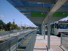
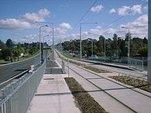
During the extension of the route from Burwood to Vermont South, all new stops were constructed as wheelchair accessible, low-floor platforms, with many other stops along the route converted to accessible platforms.[16]
There has been controversy in the local newspaper, as even though the platforms are wheelchair accessible, the route is operated with high floor trams with steps.[17] The upgrade has been criticised as a waste of money, because wheelchair-bound passengers and other mobility-impaired passengers are still limited from accessing trams on the route.
Map
| Route 75 | ||||||||||||||||||||||||||||||||||||||||||||||||||||||||||||||||||||||||||||||||||||||||||||||||||||||||||||||||||||||||||||||||||||||||||||||||||||||||||||||||||||||||
|---|---|---|---|---|---|---|---|---|---|---|---|---|---|---|---|---|---|---|---|---|---|---|---|---|---|---|---|---|---|---|---|---|---|---|---|---|---|---|---|---|---|---|---|---|---|---|---|---|---|---|---|---|---|---|---|---|---|---|---|---|---|---|---|---|---|---|---|---|---|---|---|---|---|---|---|---|---|---|---|---|---|---|---|---|---|---|---|---|---|---|---|---|---|---|---|---|---|---|---|---|---|---|---|---|---|---|---|---|---|---|---|---|---|---|---|---|---|---|---|---|---|---|---|---|---|---|---|---|---|---|---|---|---|---|---|---|---|---|---|---|---|---|---|---|---|---|---|---|---|---|---|---|---|---|---|---|---|---|---|---|---|---|---|---|---|---|---|---|
| ||||||||||||||||||||||||||||||||||||||||||||||||||||||||||||||||||||||||||||||||||||||||||||||||||||||||||||||||||||||||||||||||||||||||||||||||||||||||||||||||||||||||
|
Not all stops are shown, refer to timetable for full list of stops |
References
- ↑ Facts & figures Yarra Trams
- ↑ Route 75 Yarra Trams
- ↑ History of Trams in Melbourne, Yarra Trams, retrieved 10 October 2011
- ↑ "Melbourne Tramway and Omnibus Company Limited" (PDF), Tramway Museum Society of Victoria Running Journal Vol 9 No 3, page 16, retrieved 16 October 2011
- ↑ Milestones, 1911 – 1920, Yarra Trams, retrieved 10 October 2011
- ↑ Milestones, 1921 – 1930, Yarra Trams, retrieved 10 October 2011
- ↑ Milestones, 1951 – 1960, Yarra Trams, retrieved 28 September 2011
- ↑ Milestones, 1971 – 1980, Yarra Trams, retrieved 28 September 2011
- ↑ Milestones, 1991 – 2000, Yarra Trams, retrieved 28 September 2011
- ↑ Milestones, 2001 – 2011, Yarra Trams, retrieved 28 September 2011
- ↑ "Submission to Infrastructure Australia on Victoria's transport infrastructure priorities" (PDF), Public Transport Users Association, p. 8, retrieved 3 November 2011
- ↑ New timetable delivers more than 1,200 extra trams to Docklands effective from Sunday 26 January Public Transport Victoria 10 January 2014
- ↑ Night Tram Public Transport Victoria
- ↑ Route 732 timetable Public Transport Victoria
- ↑ "Camberwell Depot", Vicsig, retrieved 10 October 2011
- ↑ Accessible tram stops on route 75, Yarra Trams, retrieved 29 January 2012
- ↑ Rebecca Thistleton (27 September 2011). "Bridge Road trams still stop disabled". Melbourne Times Weekly. Retrieved 29 January 2012.
External links
 Media related to Melbourne tram route 75 at Wikimedia Commons
- Route 75 map
- Route 75 timetable
