Cromwell Historic District
|
Cromwell Historic District | |
|
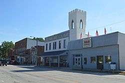
Jefferson Street north of Orange Street | |
  | |
| Location | Jefferson between 2nd and Orange Sts., Cromwell, Indiana |
|---|---|
| Coordinates | 41°24′08″N 85°36′52″W / 41.40222°N 85.61444°WCoordinates: 41°24′08″N 85°36′52″W / 41.40222°N 85.61444°W |
| Area | 7.25 acres (2.93 ha) |
| Built | 1875 |
| Architectural style | Italianate, Queen Anne, Classical Revival, Tudor Revival, Bungalow/craftsman |
| NRHP Reference # | 15000597[1] |
| Added to NRHP | September 14, 2015 |
Cromwell Historic District is a national historic district located at Cromwell, Noble County, Indiana. The district encompasses 33 contributing buildings in the central business district and surrounding residential sections of Cromwell. It developed between about 1875 and 1953, and includes notable examples of Italianate, Queen Anne, Classical Revival, Tudor Revival, and Bungalow / American Craftsman style architecture. Notable buildings include the Edwin Kline-DeMotte House (c. 1890), Forrest Henney/Henney Funeral Home (1910), Hussey House (1901), Kline Building-Maccabee Hall (c. 1880), Sparta State Bank (c. 1915), Smith’s Hall/Knights of Pythias Hall (1910), Pret Lung Meat Market (1917), Calvary Lutheran (Cromwell Evangelical Lutheran) Church (1910), and Biddle’s Bakery (1925).[2]
It was listed on the National Register of Historic Places in 2015.[1]
References
- 1 2 "National Register of Historic Places Listings". Weekly List of Actions Taken on Properties: 9/14/15 through 9/18/15. National Park Service. 2015-09-25.
- ↑ "Indiana State Historic Architectural and Archaeological Research Database (SHAARD)" (Searchable database). Department of Natural Resources, Division of Historic Preservation and Archaeology. Retrieved 2016-06-01. Note: This includes Kurt West Garner (October 2013). "National Register of Historic Places Inventory Nomination Form: Cromwell Historic District" (PDF). Retrieved 2016-06-01., Site map, quad map, and Accompanying photographs.


