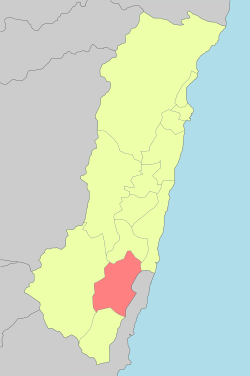
Yuli, Hualien
| Yuli Township 玉里鎮 | |
|---|---|
|
| |
 | |
| Coordinates: 23°23′15″N 121°22′35″E / 23.38750°N 121.37639°ECoordinates: 23°23′15″N 121°22′35″E / 23.38750°N 121.37639°E | |
| Country | Taiwan |
| Region | Eastern Taiwan |
| Government | |
| • Type | Urban Township |
| Area | |
| • Total | 252.3719 km2 (97.4413 sq mi) |
| Population (December 2014) | |
| • Total | 25,396 |
| Time zone | CST (UTC+8) |
| Post code | 981 |
| Subdivision | 15 Villages |
| Website | www.hlyl.gov.tw |
Yuli Township office
Yuli Township (Chinese: 玉里鎮; pinyin: Yùlǐ Zhèn; Pe̍h-ōe-jī: Gio̍k-lí) is an urban township located in central Huatung Valley, and also the southern administrative center of Hualien County, Taiwan. It has a population of 25,396 inhabitants and 15 villages.[1]
Geography
The township is located at the Huatung Valley.
Administrative divisions
Zhongcheng Village, Guowu Village, Qimo Village, Taichang Village, Yongchang Village, Yuancheng Village, Zhangliang Village, Lege Village, Tungfeng Village, Guanyin Village, Songpu Village, Chunri Village, Dewu Village, Sanmin Village, Dayu Village.
Tourist attractions
- Antong Hot Springs
- Dongfeng Leisure Farm
- Mount Chihke
- Teifen Waterfalls
- Xietian Temple
- Yucyuan Temple
- Yushan National Park[2]
Transportation

Yuli Station
- Provincial Highway No.9 (Hualien-Taitung Highway)
- Provincial Highway No.30 (Yuli-Chengbin Highway)
- TRA Yuli Station (Hwa-tung Line)
- County Road No.193
- Hualien Bus Company
See also
| Wikimedia Commons has media related to Yuli Township, Hualien County. |
References
- ↑ "Archived copy". Archived from the original on March 6, 2014. Retrieved February 17, 2014.
- ↑ http://www.erv-nsa.gov.tw/pda/Article.aspx?Lang=2&SNo=03000457
External links
- Office of Yu Li Township (Chinese)
This article is issued from Wikipedia - version of the 9/12/2016. The text is available under the Creative Commons Attribution/Share Alike but additional terms may apply for the media files.

