Yokohama, Aomori
| Yokohama 横浜町 | |||
|---|---|---|---|
| Town | |||
|
Windpower farm in Yokohama | |||
| |||
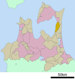
 Location of Yokohama in Aomori Prefecture | |||
 Yokohama
| |||
| Coordinates: 41°05′N 141°15′E / 41.083°N 141.250°ECoordinates: 41°05′N 141°15′E / 41.083°N 141.250°E | |||
| Country | Japan | ||
| Region | Tōhoku | ||
| Prefecture | Aomori Prefecture | ||
| District | Kamikita | ||
| Area | |||
| • Total | 126.55 km2 (48.86 sq mi) | ||
| Population (April 2012) | |||
| • Total | 4,776 | ||
| • Density | 37.7/km2 (98/sq mi) | ||
| Time zone | Japan Standard Time (UTC+9) | ||
| - Tree | Keyaki | ||
| - Flower | Rapeseed | ||
| - Bird | Plover | ||
| Phone number | 0175-78-2111 | ||
| Address |
Teranoshita 35, Yokohama-machi, Kitakami-gun, Aomori-ken 039-4145 | ||
| Website | Official website | ||

Yokohama (横浜町 Yokohama-machi) is a town located in Kamikita District of northeastern Aomori Prefecture in Tōhoku region of Japan. As of April 2012, the town had an estimated population of 4,776 and a population density of 37.7 persons per km². The total area was 38.01 km².
Geography
Yokohama occupies the northeastern coastline of Mutsu Bay, at the entrance to Shimokita Peninsula. The town has a cold maritime climate characterized by cool short summers and long cold winters with heavy snowfall.
Neighbouring municipalities
History
The area around Yokohama was controlled by the Nambu clan of Morioka Domain during the Edo period. During the cadastral reform of 1889, it was proclaimed to be a village. It was elevated to town status on April 1, 1958.
Economy
The economy of Yokohama was traditionally heavily dependent on commercial fishing in Mutsu Bay, primarily for sea cucumber, the local specialty, as well as sea urchin roe and scallops. With regards to agriculture, rapeseed predominates. Electrical power production via wind farms also contributes to the local economy.
Transportation
Railway
Highway
External links
![]() Media related to Yokohama, Aomori at Wikimedia Commons
Media related to Yokohama, Aomori at Wikimedia Commons
- Official website (Japanese)


