Tarrawanna, New South Wales
| Tarrawanna Wollongong, New South Wales | |||||||||||||
|---|---|---|---|---|---|---|---|---|---|---|---|---|---|
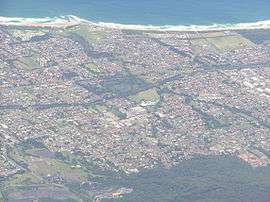
 Overlooking Tarrawanna (bottom right) and surrounding suburbs from the west. | |||||||||||||
| Coordinates | 34°22.7′S 150°53.3′E / 34.3783°S 150.8883°ECoordinates: 34°22.7′S 150°53.3′E / 34.3783°S 150.8883°E | ||||||||||||
| Population | Estimated 1,856 (2006)[1] | ||||||||||||
| Postcode(s) | 2518 | ||||||||||||
| LGA(s) | City of Wollongong | ||||||||||||
| State electorate(s) | Keira | ||||||||||||
| Federal Division(s) | Cunningham | ||||||||||||
| |||||||||||||
Tarrawanna is a northern suburb of Wollongong, New South Wales, Australia, extending westward from the Princes Highway over the Illawarra Escarpment. Tarrawanna's main street Meadow street has a few shops including a cafe, bakery, fish and chips shop and grocer.
Education
Tarrawanna has a primary school, Tarrawanna Public School on Kendall Street.
Culture
Seminal Australian grunge band The Proton Energy Pills named its 2003 anthology "Rocket To Tarrawanna" in honour of the suburb where its members lived and met.
References
- ↑ Australian Bureau of Statistics (25 October 2007). "Tarrawanna (State Suburb)". 2006 Census QuickStats. Retrieved 2010-01-16.
- http://www.environment.nsw.gov.au/resources/cultureheritage/illawarraAboriginalHistoryPoster.pdf
- http://www.southerncouncils.nsw.gov.au/vegetation/p579.html vegetation
- http://www.southerncouncils.nsw.gov.au/vegetation/bellambi.htm map with vegetation marked
- http://www.wollongong.nsw.gov.au/Residents/1048.asp Tarrawanna Community Hall
- http://wcc.wollongong.nsw.gov.au/PolicyRegister/TP%2095.6%20Foothills%20View%20Estate%20Tarrawanna.pdf
This article is issued from Wikipedia - version of the 7/2/2016. The text is available under the Creative Commons Attribution/Share Alike but additional terms may apply for the media files.