Tampa, Colorado
| Tampa | |
|---|---|
| Unincorporated community | |
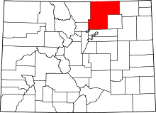
 Tampa Location within the state of Colorado | |
| Coordinates: 40°9′0″N 104°27′20″W / 40.15000°N 104.45556°WCoordinates: 40°9′0″N 104°27′20″W / 40.15000°N 104.45556°W | |
| Country | United States |
| State | Colorado |
| County | Weld |
| Time zone | Mountain (MST) (UTC-7) |
| • Summer (DST) | MDT (UTC-6) |
| ZIP codes | 80643 |
Tampa is an unincorporated community in Weld County, Colorado, United States. The rural community is served by an 80643 ZIP code.
Old timers in the area advise that Tampa was a departure point for an old railroad spur called the Tampa Spur. Tampa was located on the old CB&Q line (now BNSF, Burlington Northern, Santa Fe), about halfway between Roggen and Keenesburg.
Old timers advise that the Tampa Spur was a 1.5-mile-long railroad spur between Tampa and a place to the south called Sheehan, near the Prospect Valley, and that the spur functioned as a sugar beet dump. (A beet dump was an elevated facility that allowed farmers to deposit newly harvested produce into open railroad cars.)
According to these old timers, the Tampa Spur was built in 1882. It was still on the railroad maps in 1983, but does not appear on current railroad maps.
Plains All American Announces New Crude Oil Rail Facilities in Colorado.
Plains All American Pipeline, L.P. (NYSE:PAA) today announced it is constructing new crude oil rail facilities in Tampa, Colo. The new rail facilities and modifications are expected to be completed by the third-quarter of 2013 at an aggregate cost of approximately $125 million.
The Tampa facility is located approximately 50 miles northeast of Denver and is designed to receive crude oil via truck and pipeline and to load unit and manifest trains at a rate of up to 68,000 barrels per day. The facility is being built to service increasing DJ Basin crude oil production and is underpinned by firm contracts with large independent producers. The Tampa facility is expected to be in service in the third quarter of 2013. BNSF Railway Company will provide the rail transportation for the facility.
- Tampa Spur line, south of Tampa, CO, 1947
Geography
Tampa is located at 40.149982 degrees north, 104.455512 degrees west (27.1499982, -104.455512);[2] or about 5.5 miles northeast of Keenesburg.[3] The elevation for the community is 4,813 feet above sea level.[4] The community is adjacent to Interstate 76.
