Sikera Valley
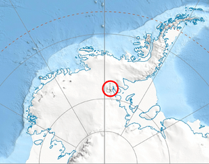
Sikera Valley (Bulgarian: долина Сикера, ‘Dolina Sikera’ \do-li-'na si-'ke-ra\) is the 17 km long and 5.7 km wide ice-filled valley between Doyran Heights and Flowers Hills on the east side of Sentinel Range in Ellsworth Mountains, Antarctica. A steep 4-km side glacier draining northeast from Mount Havener in Doyran Heights empties into the upper part of the valley next south of Kostinbrod Pass. The valley ice flows southeastwards towards Rutford Ice Stream.
The feature is named after the medieval fortress of Sikera in southeastern Bulgaria.
Location
Sikera Valley is centred at 78°30′00″S 84°13′00″W / 78.50000°S 84.21667°WCoordinates: 78°30′00″S 84°13′00″W / 78.50000°S 84.21667°W. US mapping in 1988.
Maps
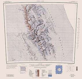
- Vinson Massif. Scale 1:250000 topographic map. Reston, Virginia: US Geological Survey, 1988.
References
- Sikera Valley. SCAR Composite Antarctic Gazetteer.
- Bulgarian Antarctic Gazetteer. Antarctic Place-names Commission. (details in Bulgarian, basic data in English)
This article includes information from the Antarctic Place-names Commission of Bulgaria which is used with permission.