Schönburg (Saale)
| Schönburg | |
|---|---|
 | |
 Schönburg | |
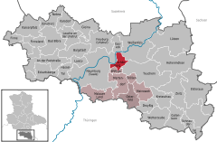
Location of Schönburg within Burgenlandkreis district 
 | |
| Coordinates: 51°10′0″N 11°52′0″E / 51.16667°N 11.86667°ECoordinates: 51°10′0″N 11°52′0″E / 51.16667°N 11.86667°E | |
| Country | Germany |
| State | Saxony-Anhalt |
| District | Burgenlandkreis |
| Municipal assoc. | Wethautal |
| Government | |
| • Mayor | Jörg Stützer |
| Area | |
| • Total | 14.83 km2 (5.73 sq mi) |
| Population (2015-12-31)[1] | |
| • Total | 1,070 |
| • Density | 72/km2 (190/sq mi) |
| Time zone | CET/CEST (UTC+1/+2) |
| Postal codes | 06618 |
| Dialling codes | 03445 |
| Vehicle registration | BLK |
| Lordship (County, Principality) of Schönburg | ||||||||||
| Herrschaft (Grafschaft, Fürstentum) Schönburg | ||||||||||
| State of the Holy Roman Empire | ||||||||||
| ||||||||||
| Capital | Schönburg (Saale) | |||||||||
| Government | Principality | |||||||||
| Historical era | Middle Ages | |||||||||
| • | Established | 1182 | ||||||||
| • | Partitioned into Upper and Lower Schönburg |
1569 | ||||||||
| • | Upper Schönburg raised to county |
1700 | ||||||||
| • | Under Vögterei of the Electorate of Saxony |
1740 | ||||||||
| • | Upper Sch partitioned to Sch-Hartenstein and Sch-Waldenburg |
1790 | ||||||||
| • | Mediatised to Saxony | 1803 | ||||||||
| ||||||||||
Schönburg is a municipality in the Burgenlandkreis district, in Saxony-Anhalt, Germany. It is situated 5 km east of Naumburg, on the river Saale. It is part of the Verbandsgemeinde ("collective municipality") Wethautal.
The castle was built by the House of Schönburg around 1120 and came into the ownership of the Bishopric of Naumburg-Zeitz during the following century.
References
- ↑ "Bevölkerung der Gemeinden – Stand: 31.12.2015" (PDF). Statistisches Landesamt Sachsen-Anhalt (in German).
This article is issued from Wikipedia - version of the 10/11/2016. The text is available under the Creative Commons Attribution/Share Alike but additional terms may apply for the media files.

