Santa Flavia
| Santa Flavia | ||
|---|---|---|
| Comune | ||
| Comune di Santa Flavia | ||
|
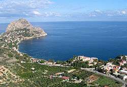
Panorama of Santa Flavia | ||
| ||
 Santa Flavia Location of Santa Flavia in Italy | ||
| Coordinates: 38°5′N 13°32′E / 38.083°N 13.533°E | ||
| Country | Italy | |
| Region | Sicily | |
| Province / Metropolitan city | Palermo (PA) | |
| Frazioni | Porticello, Sant'Elia, Solanto | |
| Government | ||
| • Mayor | Antonio Napoli | |
| Area | ||
| • Total | 14 km2 (5 sq mi) | |
| Elevation | 55 m (180 ft) | |
| Population (31 December 2010)[1] | ||
| • Total | 10,957 | |
| • Density | 780/km2 (2,000/sq mi) | |
| Demonym(s) | Flavesi | |
| Time zone | CET (UTC+1) | |
| • Summer (DST) | CEST (UTC+2) | |
| Postal code | 90017 | |
| Dialing code | 091 | |
| Patron saint | St. Anne | |
| Saint day | 26 July | |
| Website | Official website | |
Santa Flavia (known as Solunto until 1880) is a town in the province of Palermo, Sicily, southern Italy.
Overview
The town is situated between the Gulf of Palermo and the town and hot springs known as Termini Imerese, on the Tyrrhenian Sea, 15 kilometres (9 mi) east of Palermo. Inside the town are the remains of the ancient city of Soluntum.
The main agricultural product of Santa Flavia is the grapefruit. Additionally, the town, due to its location on the coast is known for its different types of fresh fish. The town caters to tourism, specifically its many seaside resorts.
Twin towns
| Wikimedia Commons has media related to Santa Flavia. |
References
This article is issued from Wikipedia - version of the 6/24/2014. The text is available under the Creative Commons Attribution/Share Alike but additional terms may apply for the media files.

