Saint-Hubert, Belgium
| Saint-Hubert | |||
|---|---|---|---|
| Municipality | |||
 | |||
| |||
 Saint-Hubert Location in Belgium | |||
|
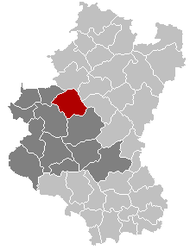
Location of Saint-Hubert in Luxembourg province  | |||
| Coordinates: 50°1.53′N 05°22.45′E / 50.02550°N 5.37417°ECoordinates: 50°1.53′N 05°22.45′E / 50.02550°N 5.37417°E | |||
| Country | Belgium | ||
| Community | French Community | ||
| Region | Wallonia | ||
| Province | Luxembourg | ||
| Arrondissement | Neufchâteau | ||
| Government | |||
| • Mayor | Louis Devaux (IC) | ||
| • Governing party/ies | Pour Servir, IC | ||
| Area | |||
| • Total | 111.16 km2 (42.92 sq mi) | ||
| Population (1 January 2016)[1] | |||
| • Total | 5,553 | ||
| • Density | 50/km2 (130/sq mi) | ||
| Postal codes | 6870 | ||
| Area codes | 061 | ||
| Website | www.saint-hubert.be | ||
Saint-Hubert (French pronunciation: [sɛ̃.t‿y.bɛʁ]) is a Walloon municipality of Belgium located in the province of Luxembourg. On 1 January 2007 the municipality, which covers 111.16 km², had 5,737 inhabitants, giving a population density of 51.6 inhabitants per square kilometre.
The municipality consists of the following sub-municipalities: Saint-Hubert proper, Arville, Awenne, Hatrival, Mirwart, and Vesqueville. Other population centers include: Lorcy and Poix-Saint-Hubert.
The town is named in commemoration of Saint Hubert, whose thighbones were moved in 825 to the Benedictine Abbey of Andage, thereafter called 'Abbey of Saint-Hubert'.
Climate
| Climate data for Saint Hubert | |||||||||||||
|---|---|---|---|---|---|---|---|---|---|---|---|---|---|
| Month | Jan | Feb | Mar | Apr | May | Jun | Jul | Aug | Sep | Oct | Nov | Dec | Year |
| Average high °C (°F) | 2.3 (36.1) |
3.2 (37.8) |
6.7 (44.1) |
9.9 (49.8) |
14.7 (58.5) |
17.1 (62.8) |
19.6 (67.3) |
19.6 (67.3) |
15.9 (60.6) |
11.4 (52.5) |
5.8 (42.4) |
3.3 (37.9) |
10.79 (51.43) |
| Average low °C (°F) | −2.3 (27.9) |
−2.4 (27.7) |
−0.1 (31.8) |
1.9 (35.4) |
6.2 (43.2) |
8.9 (48) |
11.1 (52) |
11.1 (52) |
8.4 (47.1) |
5.0 (41) |
1.0 (33.8) |
−0.9 (30.4) |
3.99 (39.19) |
| Average precipitation mm (inches) | 96.9 (3.815) |
76.0 (2.992) |
95.3 (3.752) |
76.8 (3.024) |
85.7 (3.374) |
100.4 (3.953) |
91.9 (3.618) |
72.9 (2.87) |
88.1 (3.469) |
102.7 (4.043) |
105.7 (4.161) |
108.8 (4.283) |
1,101.2 (43.354) |
| Average precipitation days | 15 | 12 | 15 | 13 | 13 | 13 | 12 | 10 | 12 | 13 | 15 | 16 | 159 |
| Source: World Meteorological Organisation (UN) [2] | |||||||||||||
See also

The Benedictine monastery of Our Lady of Hurtebise (near Saint-Hubert)
References
- ↑ Population per municipality as of 1 January 2016 (XLS; 397 KB)
- ↑ "World Weather Information Service – Saint Hubert". United Nations. Retrieved 19 January 2011.
External links
| Wikimedia Commons has media related to Saint-Hubert, Belgium. |
- Official website (in French)
 |
Nassogne | Tenneville |  | |
| Tellin | |
Sainte-Ode | ||
| ||||
| | ||||
| Libin | Libramont-Chevigny |
This article is issued from Wikipedia - version of the 12/1/2016. The text is available under the Creative Commons Attribution/Share Alike but additional terms may apply for the media files.


