Romans-sur-Isère
| Romans-sur-Isère | |
|---|---|
 | |
 Romans-sur-Isère | |
|
Location within Auvergne-Rhône-Alpes region  Romans-sur-Isère | |
| Coordinates: 45°02′47″N 5°03′06″E / 45.0464°N 5.0517°ECoordinates: 45°02′47″N 5°03′06″E / 45.0464°N 5.0517°E | |
| Country | France |
| Region | Auvergne-Rhône-Alpes |
| Department | Drôme |
| Arrondissement | Valence |
| Intercommunality | Pays de Romans |
| Government | |
| • Mayor (2014-2020) | Marie-Hélène Thoraval |
| Area1 | 33.08 km2 (12.77 sq mi) |
| Population (2012)2 | 33,701 |
| • Density | 1,000/km2 (2,600/sq mi) |
| Time zone | CET (UTC+1) |
| • Summer (DST) | CEST (UTC+2) |
| INSEE/Postal code | 26281 / 26100 |
| Elevation |
122–291 m (400–955 ft) (avg. 167 m or 548 ft) |
|
1 French Land Register data, which excludes lakes, ponds, glaciers > 1 km² (0.386 sq mi or 247 acres) and river estuaries. 2 Population without double counting: residents of multiple communes (e.g., students and military personnel) only counted once. | |
Romans-sur-Isère ([ʁɔ.mɑ̃.syʁ.i.zɛːʁ]; Occitan: Rumans d'Isèra;[1]Old Occitan: Romans) is a commune in the Drôme department in southeastern France.
Geography
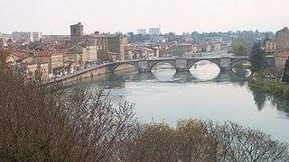
Romans-sur-Isère is located on the Isère River, 20 km (12 mi) northeast of Valence. There are more than 50,000 inhabitants in the urban area (if the neighboring town of Bourg-de-Péage is included). Romans is close to the Vercors.
Population
| Historical population | ||
|---|---|---|
| Year | Pop. | ±% |
| 1793 | 5,742 | — |
| 1800 | 6,473 | +12.7% |
| 1806 | 6,997 | +8.1% |
| 1821 | 8,837 | +26.3% |
| 1831 | 9,285 | +5.1% |
| 1836 | 9,972 | +7.4% |
| 1841 | 9,471 | −5.0% |
| 1846 | 9,958 | +5.1% |
| 1851 | 10,869 | +9.1% |
| 1856 | 11,219 | +3.2% |
| 1861 | 11,257 | +0.3% |
| 1866 | 11,524 | +2.4% |
| 1872 | 12,674 | +10.0% |
| 1876 | 12,923 | +2.0% |
| 1881 | 13,806 | +6.8% |
| 1886 | 14,733 | +6.7% |
| 1891 | 16,545 | +12.3% |
| 1896 | 16,702 | +0.9% |
| 1901 | 17,140 | +2.6% |
| 1906 | 17,622 | +2.8% |
| 1911 | 17,201 | −2.4% |
| 1921 | 17,054 | −0.9% |
| 1926 | 17,596 | +3.2% |
| 1931 | 18,957 | +7.7% |
| 1936 | 19,489 | +2.8% |
| 1946 | 15,972 | −18.0% |
| 1954 | 22,559 | +41.2% |
| 1962 | 26,377 | +16.9% |
| 1968 | 31,545 | +19.6% |
| 1975 | 33,030 | +4.7% |
| 1982 | 33,152 | +0.4% |
| 1990 | 32,734 | −1.3% |
| 1999 | 32,667 | −0.2% |
| 2008 | 33,440 | +2.4% |
| 2012 | 33,701 | +0.8% |
Economy
- Nuclear fuel manufacture (FBFC, Franco-Belge de Fabrication du Combustible), Areva subsidiary.
- Shoe manufacture (including Robert Clergerie)
History
- Historian Emmanuel Le Roy Ladurie wrote Carnaval de Romans (1980) a microhistorical study, based on the only two surviving eyewitness accounts, of the 1580 massacre of about twenty artisans at the annual carnival in the town. He treats the massacre as a microcosm of the political, social and religious conflicts of rural society in the latter half of the 16th century in France.
Sights
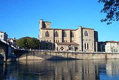
- Collegiate church of St. Barnard
- International Museum of Footwear
- Tower of Jacquemart clock

Église Saint-Barnard
International relations
Twin towns – Sister cities
Romans-sur-Isère is twinned with:
Notable people
- Robert Clergerie, shoe designer
- Ernest Gailly, former mayor
- Jules Nadi (1872-1928) former mayor and councillor who did much to develop the city
- Philippe Saint-André, rugby player and national team coach
- Pierre Latour ((1993-), cyclist
See also
References
- ↑ BOUVIER Jean-Claude (1976) Les parlers provençaux de la Drôme. Étude de géographie phonétique, coll. Bibliothèque française et romane A-33, Paris: Klincksieck, pp. 445-518
External links
| Wikimedia Commons has media related to Romans-sur-Isère. |
- Town council website (French)
- Communauté de communes du Pays de Romans website
- New Uranium Leak Found in French Areva Factory
This article is issued from Wikipedia - version of the 9/10/2016. The text is available under the Creative Commons Attribution/Share Alike but additional terms may apply for the media files.