Ponta dos Rosais
| Ponta dos Rosais | |
| Headland (Ponta) | |
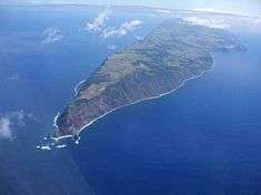 An expansive view of Ponta dos Rosais, on the tip of the island of São Jorge | |
| Official name: Ponta dos Rosais | |
| Named for: Rosais | |
| Country | |
|---|---|
| Autonomous Region | |
| Islands | Eastern Group |
| Location | Azores Platform, Mid-Atlantic Ridge, Atlantic Ocean |
| Municipalities | Velas |
| Landmark | Lighthouse of Rosais |
| Coordinates | 38°45′20″N 28°19′1″W / 38.75556°N 28.31694°WCoordinates: 38°45′20″N 28°19′1″W / 38.75556°N 28.31694°W |
| Biomes | Temperate, Mediterranean |
| Geology | Alkali basalt, Tephra, Trachyte, Trachybasalt |
| Orogeny | Volcanism |
| Period | Holocene |
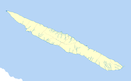 Location of the point on the island of São Jorge | |
| Wikimedia Commons: Ponta dos Rosais | |
| Geographic detail from Portuguese Army map[1] | |
Ponta dos Rosais (Rosais Point) is a promontory located along the north coast of the parish of Rosais, municipality of Velas in the island of São Jorge in the Portuguese archipelago of the Azores.
Geography

The promontory of Ponta dos Rosais is situated on a 200 metres (660 ft) above the waters of the Atlantic on the northern tip of the island of São Jorge.[2] With a view to the distant islands of Faial, Pico and Graciosa, little more than 15 kilometres (9.3 mi) from the point, and extends north-northwest from the small islet of Rosais towards the Baixa da Ponta dos Rosais.[2]
On the promontory is the isolated, mid-century Nationalist, lighthouse complex of Ponta dos Rosais.
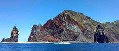
This nature reserve and natural monument stretches the coastal cliffs from Pico dos Cutelos (along the southern coast) to northern cliffs and pasturelands of Chã do Areeiro. The reserve includes the waters surrounding the point, the islet of Rosais, Ponta da Ilha and Torrão da Açucar, as well as the Fajã do Mata Sete, an area of basalt rocks, stacks and mixture of pyroclastic flow and erosional debris.[2] There are treacherous trails and alternative routes that link these zones, most skirting the coastal seashore.[2]
Biome
The uplands are primarily pasture-land and agricultural areas, with most of the region taken-up by rural activities. Tourists visiting the area are attracted by the diversity of migratory and maritime bird species that nest in the cliffs of the point, including the migratory Corey's Shearwater (Calonectris diomedea) and Little shearwater (Puffinus assimilis), but also the Roseate (Sterna dougallii) and Common Terns (Sterna hirundo).[2][3]
Endemic predator species in these areas include feral cats and dogs, as well as rodents, but the latter limited by local kite species.
But, the region is a hothouse of Azorean heather (Erica azorica) and Forget-me-nots (Myosotis azorica).[2][3]
References
- Notes
- ↑ Map nr. 14 Farol de Rosais (S. Jorge, Açores) 1:25,000, Instituto Geográfico do Exército, retrieved 1 December 2015
- 1 2 3 4 5 6 "Baixa da Ponta dos Rosais" (in Portuguese). Horta (Azores), Portugal: Department of Oceangraphy and Fisheries/University of the Azores. 2012.
- 1 2 SRAM, ed. (2011). "Monumento Natural da Ponta de Rosais". Horta (Azores), Portugal: Secretaria Regional da Agricultura e Ambiente.
- Sources
- Ferraz, Rogério R.; Santos, Vanessa; Vizinho, Samanta; Cardigos, Frederico; Frade, Pedro; Guerreiro, Vera; Tempera, Fernando; Santos, Ricardo S. (4 October 2004), Caracterização Ecológica e Sócio-Económica do Sítio de Importância Comunitária Ponta dos Rosais (PTJOR0013) e Medidas de Gestão Propostas (PDF) (in Portuguese), Horta (Azores), Portugal: Department de Ocenaografia e Pescas/University of the Azores, retrieved 30 December 2014