Lighthouse of Ponta dos Rosais
| Lighthouse of Ponta dos Rosais (Farol da Ponta dos Rosais) | |
| Rosais Point Lighthouse | |
| Lighthouse (Farol) | |
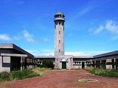 The front façade of the Ponta dos Rosais Lighthouse and complex, abandoned after the 1964 Rosais Earthquake | |
| Official name: Farol da Ponta dos Rosais | |
| Name origin: ponta dos rosais Portuguese for Rosais Point, the extreme western point on the island of São Jorge | |
| Country | |
|---|---|
| Autonomous Region | |
| Group | Central |
| Island | São Jorge |
| Municipality | Velas |
| Location | Ponta dos Rosias |
| - elevation | 233 m (764 ft) |
| - coordinates | 38°45′13″N 28°18′42″W / 38.75361°N 28.31167°WCoordinates: 38°45′13″N 28°18′42″W / 38.75361°N 28.31167°W |
| Length | 47.0 m (154 ft), Northwest-Southeast |
| Width | 38.25 m (125 ft), Southwest-Northeast |
| Height | 34 m (112 ft) |
| Altitude | 200 m (656 ft) |
| Style | Modern |
| Material | Cement |
| Origin | c. 1958 |
| - Initiated | 1 May 1958 |
| - Completed | c. 1964 |
| Abandoned | 1 January 1980 |
| - Automated | 5 July 1982 |
| Owner | Portuguese Republic |
| For public | Public |
| Visitation | Closed to Visits |
| Management | Marinha de Portugal |
| Operator | Direcção de Faróis |
| ARLHS[1] | AZO-019 |
| Admiralty[2] | D2683 |
| NGA[3] | 23448 |
| Type | Dioptric-retroreflecting, with a third-order rotational beacon |
| Focal distance | 500 mm |
| Beam distance | 8 nautical miles (15 km; 9.2 mi) |
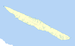 Location of the lighthouse on the island of São Jorge | |
| Wikimedia Commons: Rosais Lighthouse | |
The Ponta dos Rosais Lighthouse (Portuguese: Farol da Ponta dos Rosais) is a beacon/lighthouse located along the 200m cliffs of Ponta dos Rosais near Rosais in the extreme northwest of the island of São Jorge, in the Archipelago of the Azores, Portugal. It includes the main 200 m structure/tower and several living quarters and auxiliary buildings constructed for the maintenance and operation of the lighthouse, currently abandoned and in ruins. This includes structures such as a motor-pool, a communal hearth and a series of concrete lavoirs for washing, as well as the larger block devoted to administration and private residences.
History
There was already a notion, by 1890, that a beacon was necessary on the western coast of São Jorge, and a lighthouse was planned for the region.[4]
In 1956, the project was continued by the Comissão Administrativa das Novas Instalações (Administrative Commission for New Installations), an arm of the Portuguese Navy (with a completion predicted for 1957).[4] Yet, by that time the project continued to be audited by the Administrative Commission of the Navy.[4]
At the conclusion of the building project (in 1958), the installation of the equipment began on 1 May, which included mounting of the dual-optical cathode beacon which permitted a 500-metre focal distance.[4] Power was provided by groups of groups of engines that provided power to its 3000 watt/110 volt acetylene lamp.[4] It was finally completed and inaugurated in 1964. At the time of its construction, it was the most advanced lighthouse in the Portuguese network. It was also a self-sufficient complex, with residences for several families, an independent water supply and a power-source to operate independently from the rest of the parish.
Shortly after the lighthouse was completed, it was abandoned during the 1964 Rosais Earthquake, when seismic events and an underwater eruption hit the Ponta dos Rosais, causing damage to 900 homes and 400 buildings in the parish of Rosais.[4] The earthquake caused enough panic to warrant the evacuation of its residents to the neighbouring island of Terceira, which included the temporary evacuation of the lighthouse families. Over time these fears were mitigated and life resumed at the complex.
There was a substitution of the main lamp for dioptic model with 150 mm focal distance, and with 50 watt/12 volt capacity and supported by batteries charged by photovoltaic solar panels. The change, although more efficient, allowed the beacon to be seen for 8 miles (13 km).
Then, on 1 January 1980, a series of seismic events, in the order of 7 on the Richter magnitude scale caused destruction to homes on Terceira, Graciosa, Faial and São Jorge islands. These events caused significant damage to the structure of the lighthouse and buildings, necessitating a complete abandonment of the complex.[4]
The lighthouse was automated and reopened on 5 July 1982.[4]
References
- Notes
- ↑ "Identification Codes", ARLHS World List of Lights (WLOL), Merchantville, New Jersey: Amateur Radio Lighthouse Society/The Weidner Publishing Group., 2003, retrieved 18 July 2011
- ↑ "Notice to Mariners", Admiralty List of Lights (ALL), Tauton, Sommerset, England: United Kingdom Hydrohraphic Office, 2011, retrieved 18 July 2011
- ↑ "Maritime Safety Information", NGA List of Lights, Springfield, Virginia: U.S. National Geospatial-Intelligence Agency (NGA), 2011, retrieved 18 July 2011
- 1 2 3 4 5 6 7 8 Costa, Patrícia (2003), SIPA, ed., Farol dos Rosais (in Portuguese), Lisbon, Portugal: SIPA – Sistema de Informação para o Património Arquitectónico
- Sources
- Furtado, Eduardo Carvalho Vieira (2005). Guardiães do Mar dos Açores: uma viagem pelas ilhas do Atlântico [Guardians of the Sea of the Azores: a trip across the Atlantic islands]. p. 289. ISBN 972-9060-47-9.
- Ministério das Obras Públicas, ed. (1957), Relatório da Actividade do Ministério no ano de 1956 (in Portuguese), Lisbon, Portugal
- Ministério das Obras Públicas, ed. (1959), Relatório da Actividade do Ministério nos anos de 1957 e 1958 (in Portuguese), 1–2, Lisbon, Portugal