| [3] |
Name on the Register |
Image |
Date listed[4] |
Location |
City or town |
Description |
|---|
| 1 |
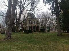
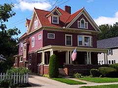
Adams-Ryan House |
|
000000001985-09-05-0000September 5, 1985
(#85001957) |
425 Washington St.
43°11′46″N 77°51′17″W / 43.196111°N 77.854722°W / 43.196111; -77.854722 (Adams-Ryan House) |
Adams Basin |
|
| 2 |
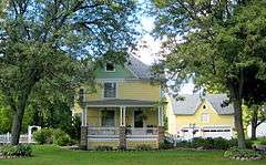
Adsit Cobblestone Farmhouse |
|
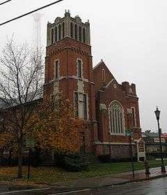
000000001996-11-29-0000November 29, 1996
(#96001393) |
3871 Clover St.
43°00′51″N 77°35′05″W / 43.014167°N 77.584722°W / 43.014167; -77.584722 (Adsit Cobblestone Farmhouse) |
Mendon |
Federal style cobblestone farmhouse from c.1832. Operated as an inn during the mid-19th century, it was used by farmers delivering grain on the road from Canandaigua to Rochester.[5]
|
| 3 |
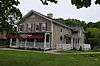
Alcoa Care-free Home |
|
000000002010-06-18-0000June 18, 2010
(#10000358) |
1589 Clover St.
43°07′39″N 77°32′49″W / 43.1274°N 77.547019°W / 43.1274; -77.547019 (Alcoa Care-free Home) |
Brighton |
|
| 4 |
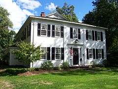
Antoinette Louisa Brown Blackwell Childhood Home |
|
000000001989-11-16-0000November 16, 1989
(#89002003) |
1099 Pinnacle Rd.
43°03′05″N 77°36′00″W / 43.051389°N 77.6°W / 43.051389; -77.6 (Antoinette Louisa Brown Blackwell Childhood Home) |
Henrietta |
|
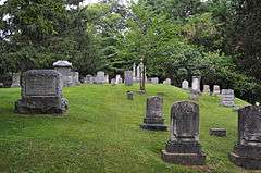
| 5 |
Brockport Cemetery |
Upload image |
000000002016-03-08-0000March 8, 2016
(#16000061) |
56-98 High St.
Coordinates missing |
Brockport |
Community's primary burial ground for most of the 19th century
|
| 6 |
Brockport Central Rural High School |
|
000000002011-11-10-0000November 10, 2011
(#11000805) |
40 Allen St.
43°12′26″N 77°56′51″W / 43.207294°N 77.947447°W / 43.207294; -77.947447 (Brockport Central Rural High School) |
Brockport |
|
| 7 |
Horace and Grace Bush House |
|
000000001994-06-10-0000June 10, 1994
(#94000590) |
1932 Five Mile Line Rd.
43°08′33″N 77°28′36″W / 43.1425°N 77.476667°W / 43.1425; -77.476667 (Horace and Grace Bush House) |
Penfield |
|
| 8 |
Chase Cobblestone Farmhouse |
|
000000001995-11-07-0000November 7, 1995
(#95001279) |
1191 Manitou Rd., Town of Parma
43°15′21″N 77°45′21″W / 43.255833°N 77.755833°W / 43.255833; -77.755833 (Chase Cobblestone Farmhouse) |
Hilton |
|
| 9 |
Chili Mills Conservation Area |
Upload image |
000000001975-03-12-0000March 12, 1975
(#75001198) |
1 mi. SW of West Chili off Stuart Rd. along Black Creek
43°04′56″N 77°49′10″W / 43.082222°N 77.819444°W / 43.082222; -77.819444 (Chili Mills Conservation Area) |
West Chili |
|
| 10 |
Clarkson Corners Historic District |
|
000000001994-09-02-0000September 2, 1994
(#94001076) |
Jct. of Ridge and Lake Rds. and E and W along Ridge and S along Lake
43°13′57″N 77°55′44″W / 43.2325°N 77.928889°W / 43.2325; -77.928889 (Clarkson Corners Historic District) |
Clarkson Corners |
|
| 11 |
Cole Cobblestone Farmhouse |
|
000000001996-11-29-0000November 29, 1996
(#96001394) |
933 Mile Square Rd.
43°00′52″N 77°29′47″W / 43.014444°N 77.496389°W / 43.014444; -77.496389 (Cole Cobblestone Farmhouse) |
Mendon |
|
| 12 |
Austin R. Conant House |
Upload image |
000000002016-08-23-0000August 23, 2016
(#16000554) |
30 West St.
Coordinates missing |
Fairport |
1876 Gothic Revival house was home to a number of important early residents of Fairport as it boomed around the Erie Canal
|
| 13 |
William Covert Cobblestone Farmhouse |
|
000000001995-11-07-0000November 7, 1995
(#95001280) |
978 N. Greece Rd.
43°13′48″N 77°43′51″W / 43.23°N 77.730833°W / 43.23; -77.730833 (William Covert Cobblestone Farmhouse) |
Greece |
|
| 14 |
Isaac Cox Cobblestone Farmstead |
|
000000002003-03-07-0000March 7, 2003
(#03000092) |
5015 River Rd.
42°59′42″N 77°44′43″W / 42.995°N 77.745278°W / 42.995; -77.745278 (Isaac Cox Cobblestone Farmstead) |
Scottsville |
|
| 15 |
Cox–Budlong House |
|
000000002015-02-12-0000February 12, 2015
(#15000007) |
4396 River Rd.
43°00′50″N 77°44′48″W / 43.013827°N 77.746738°W / 43.013827; -77.746738 (Cox–Budlong House) |
Scottsville |
1820 Federal style house by early settler of Wheatland later renovated in Greek Revival and Italianate styles
|
| 16 |
Curtis-Crumb Farm |
|
000000001997-01-03-0000January 3, 1997
(#96001509) |
307 Curtis Rd.
43°18′24″N 77°46′53″W / 43.306667°N 77.781389°W / 43.306667; -77.781389 (Curtis-Crumb Farm) |
Hilton |
|
| 17 |
Daisy Flour Mill, Inc. |
|
000000001972-06-26-0000June 26, 1972
(#72000855) |
1880 Blossom Rd.
43°08′49″N 77°30′45″W / 43.146944°N 77.5125°W / 43.146944; -77.5125 (Daisy Flour Mill, Inc.) |
Penfield |
A former flour mill, now a restaurant and party house.
|
| 18 |
Dayton's Corners School |
|
000000002001-07-05-0000July 5, 2001
(#01000716) |
1363 Creek St.
43°10′56″N 77°30′09″W / 43.182222°N 77.5025°W / 43.182222; -77.5025 (Dayton's Corners School) |
Penfield |
A one-room schoolhouse, Penfield District #9. Now used for fourth-grade local history studies.
|
| 19 |
Henry DeLand House |
|
000000001980-04-17-0000April 17, 1980
(#80004610) |
99 S. Main St.
43°05′55″N 77°26′31″W / 43.098611°N 77.441944°W / 43.098611; -77.441944 (Henry DeLand House) |
Fairport |
Home of Henry Addison DeLand, it later became an inn, restaurant, speakeasy, bar and a catering hall.
|
| 20 |
First Baptist Church |
|
000000002011-10-20-0000October 20, 2011
(#11000752) |
124 Main St.
43°12′50″N 77°56′22″W / 43.213889°N 77.939444°W / 43.213889; -77.939444 (First Baptist Church) |
Brockport |
|
| 21 |
First Baptist Church of Fairport |
|
000000002006-09-28-0000September 28, 2006
(#06000892) |
94 S. Main St.
43°06′02″N 77°26′32″W / 43.100556°N 77.442222°W / 43.100556; -77.442222 (First Baptist Church of Fairport) |
Fairport |
A church undergoing restoration
|
| 22 |
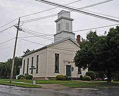
First Baptist Church of Mumford |
|
000000002010-03-23-0000March 23, 2010
(#10000100) |
5 Dakin St.
42°59′25″N 77°51′35″W / 42.99035°N 77.859767°W / 42.99035; -77.859767 (First Baptist Church of Mumford) |
Mumford |
|
| 23 |
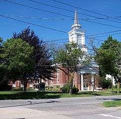
First Presbyterian Church |
|
000000001999-06-25-0000June 25, 1999
(#99000752) |
35 State St.
43°12′52″N 77°56′14″W / 43.2144°N 77.9372°W / 43.2144; -77.9372 (First Presbyterian Church) |
Brockport |
|
| 24 |
First Presbyterian Church of Mumford |
|
000000002002-04-01-0000April 1, 2002
(#02000299) |
George and William Sts.
42°59′32″N 77°51′42″W / 42.992155°N 77.861691°W / 42.992155; -77.861691 (First Presbyterian Church of Mumford) |
Mumford |
|
| 25 |
Andrew Short House |
|
000000002014-02-14-0000February 14, 2014
(#14000005) |
1294 Lehigh Station Rd.
43°03′34″N 77°37′54″W / 43.059529°N 77.6315897°W / 43.059529; -77.6315897 (Andrew Short House) |
Henreietta |
|
| 26 |
Garbuttsville Cemetery |
|
000000002006-11-29-0000November 29, 2006
(#06001077) |
Union St.
43°00′54″N 77°47′29″W / 43.015°N 77.791389°W / 43.015; -77.791389 (Garbuttsville Cemetery) |
Garbutt |
|
| 27 |
Gates-Livermore Cobblestone Farmhouse |
|
000000001996-11-29-0000November 29, 1996
(#96001390) |
4389 Clover St.
42°59′29″N 77°34′51″W / 42.991389°N 77.580833°W / 42.991389; -77.580833 (Gates-Livermore Cobblestone Farmhouse) |
Mendon |
|
| 28 |
Grace Church |
|
000000002010-07-30-0000July 30, 2010
(#10000514) |
9 Browns Ave.
43°01′22″N 77°45′05″W / 43.022778°N 77.751389°W / 43.022778; -77.751389 (Grace Church) |
Scottsville |
|
| 29 |
Greece Memorial Hall |
Upload image |
000000001998-04-23-0000April 23, 1998
(#98000395) |
2595 Ridge Rd. W
43°12′34″N 77°41′43″W / 43.209444°N 77.695278°W / 43.209444; -77.695278 (Greece Memorial Hall) |
Greece |
|
| 30 |
Edward Harrison House |
|
000000002010-10-22-0000October 22, 2010
(#10000854) |
75 College St.
43°12′42″N 77°56′42″W / 43.211667°N 77.945°W / 43.211667; -77.945 (Edward Harrison House) |
Brockport |
|
| 31 |
Hildreth-Lord-Hawley Farm |
|
000000001996-10-29-0000October 29, 1996
(#96001169) |
44 N. Main St.
43°05′37″N 77°30′48″W / 43.093611°N 77.513333°W / 43.093611; -77.513333 (Hildreth-Lord-Hawley Farm) |
Pittsford |
|
| 32 |
Franklin Hinchey House |
|
000000001983-11-10-0000November 10, 1983
(#83004045) |
634 Hinchey Rd.
43°08′12″N 77°41′27″W / 43.136667°N 77.690833°W / 43.136667; -77.690833 (Franklin Hinchey House) |
Gates |
|
| 33 |
Hipp-Kennedy House |
|
000000001994-02-04-0000February 4, 1994
(#94000003) |
1931 Five Mile Line Rd.
43°08′34″N 77°28′35″W / 43.142778°N 77.476389°W / 43.142778; -77.476389 (Hipp-Kennedy House) |
Penfield |
|
| 34 |
Honeoye Falls Village Historic District |
|
000000001993-11-24-0000November 24, 1993
(#93001225) |
Roughly, jct. of Main, Monroe and Ontario Sts. and adjacent areas
42°56′54″N 77°35′32″W / 42.948333°N 77.592222°W / 42.948333; -77.592222 (Honeoye Falls Village Historic District) |
Honeoye Falls |
|
| 35 |
Hopkins Farm |
|
000000002000-10-06-0000October 6, 2000
(#00001153) |
3151 Clover St.
43°03′40″N 77°33′28″W / 43.061111°N 77.557778°W / 43.061111; -77.557778 (Hopkins Farm) |
Pittsford |
|
| 36 |
House at 288 Wimbledon Road |
|
000000002015-11-24-0000November 24, 2015
(#15000822) |
288 Wimbledon Rd.
43°12′18″N 77°36′36″W / 43.204922°N 77.610000°W / 43.204922; -77.610000 (House at 288 Wimbledon Road) |
Irondequoit |
Demonstration house built in 1928 by Fred P. Tosch Inc. and co-sponsored by the Democrat & Chronicle and Home Owners Service Institute to promote high quality design and cutting edge construction for middle income families.
|
| 37 |
Thomas L. Hulburt House |
Upload image |
000000002016-02-16-0000February 16, 2016
(#16000019) |
106 Hulburt Rd
Coordinates missing |
Fairport |
1853 Greek Revival house of lawyer and developer instrumental to Fairport's growth
|
| 38 |
Jayne and Mason Bank Building |
|
000000002006-11-01-0000November 1, 2006
(#06000970) |
11 E. Main St.
43°12′50″N 77°25′47″W / 43.213889°N 77.429722°W / 43.213889; -77.429722 (Jayne and Mason Bank Building) |
Webster |
Currently a secondhand shop called "Nest Things"
|
| 39 |
William C. Jayne House |
|
000000002006-09-28-0000September 28, 2006
(#06000891) |
183 E. Main St.
43°12′53″N 77°25′23″W / 43.214722°N 77.423056°W / 43.214722; -77.423056 (William C. Jayne House) |
Webster |
|
| 40 |
Lake View Cemetery |
|
000000002009-07-24-0000July 24, 2009
(#09000559) |
NY 19
43°12′38″N 77°56′02″W / 43.210678°N 77.933853°W / 43.210678; -77.933853 (Lake View Cemetery) |
Brockport |
|
| 41 |
Adolph Lomb House |
|
000000001995-01-24-0000January 24, 1995
(#94001597) |
Jct. of Sutherland St. and W. Jefferson Rd.
43°05′20″N 77°31′26″W / 43.088889°N 77.523889°W / 43.088889; -77.523889 (Adolph Lomb House) |
Pittsford |
|
| 42 |
Lower Mill |
|
000000001973-05-17-0000May 17, 1973
(#73001200) |
N. Main St.
42°57′22″N 77°35′20″W / 42.956°N 77.5888°W / 42.956; -77.5888 (Lower Mill) |
Honeoye Falls |
|
| 43 |
Main Street Historic District |
|
000000002004-04-02-0000April 2, 2004
(#04000227) |
Main, Market and King Sts.
43°13′00″N 77°56′18″W / 43.216667°N 77.938333°W / 43.216667; -77.938333 (Main Street Historic District) |
Brockport |
|
| 44 |
Donald Mann House |
|
000000002013-06-25-0000June 25, 2013
(#13000449) |
327 Stewart Rd.
43°00′02″N 77°48′24″W / 43.000462°N 77.8067436°W / 43.000462; -77.8067436 (Donald Mann House) |
Scottsville |
|
| 45 |
George G. Mason House |
|
000000002004-10-27-0000October 27, 2004
(#04001206) |
39 Dunning Ave.
43°12′49″N 77°25′34″W / 43.213611°N 77.426111°W / 43.213611; -77.426111 (George G. Mason House) |
Webster |
|
| 46 |
David McVean House |
|
000000002006-01-18-0000January 18, 2006
(#05001531) |
805 North Rd.
43°01′41″N 77°45′38″W / 43.028056°N 77.760556°W / 43.028056; -77.760556 (David McVean House) |
Scottsville |
|
| 47 |
Mendon Cobblestone Academy |
|
000000001996-11-29-0000November 29, 1996
(#96001395) |
16 Mendon-Ionia Rd.
42°59′48″N 77°30′18″W / 42.996667°N 77.505°W / 42.996667; -77.505 (Mendon Cobblestone Academy) |
Mendon |
|
| 48 |
Mendon Presbyterian Church |
|
000000002005-12-23-0000December 23, 2005
(#05001455) |
3886 Rush-Mendon Rd.
43°00′00″N 77°30′25″W / 43.0°N 77.506944°W / 43.0; -77.506944 (Mendon Presbyterian Church) |
Mendon |
|
| 49 |
Romanta T. Miller House |
|
000000002014-04-11-0000April 11, 2014
(#14000144) |
1089 Bowerman Rd.
42°59′25″N 77°46′11″W / 42.990181°N 77.7697369°W / 42.990181; -77.7697369 (Romanta T. Miller House) |
Wheatland |
|
| 50 |
Miller–Horton–Barben Farm |
Upload image |
000000002015-01-14-0000January 14, 2015
(#14001161) |
983 W. Bloomfield Rd.
42°59′34″N 77°31′42″W / 42.992826°N 77.5283367°W / 42.992826; -77.5283367 (Miller–Horton–Barben Farm) |
Mendon |
Established in 1808, this 90-acre (36 ha) farm is one of the oldest in town
|
| 51 |
Morgan-Manning House |
|
000000001991-04-25-0000April 25, 1991
(#91000443) |
151 Main St.
43°12′45″N 77°56′22″W / 43.2125°N 77.939444°W / 43.2125; -77.939444 (Morgan-Manning House) |
Brockport |
|
| 52 |
Mud House |
|
000000001978-10-11-0000October 11, 1978
(#78001862) |
1000 Whalen Rd.
43°08′31″N 77°27′36″W / 43.141944°N 77.46°W / 43.141944; -77.46 (Mud House) |
Penfield |
|
| 53 |
New York State Barge Canal |
|
000000002014-10-15-0000October 15, 2014
(#14000860) |
Linear across county
Coordinates missing |
Brighton, Brockport, Chili, Clarkson, Fairport, Gates, Greece, Henrietta, Ogden, Perinton, Pittsford, Spencerport, Sweden |
Successor to Erie Canal approved by state voters in early 20th century to compete with railroads.
|
| 54 |
North Star School District No. 11 |
Upload image |
000000002014-09-10-0000September 10, 2014
(#14000579) |
660 Walker Lake Ontario Rd.
43°19′08″N 77°51′36″W / 43.318833°N 77.859917°W / 43.318833; -77.859917 (North Star School District No. 11) |
Hamlin |
Late 19th-century one-room schoolhouse now serves as local history museum
|
| 55 |
Oatka Cemetery |
|
000000002014-02-24-0000February 24, 2014
(#14000025) |
411 Scottsville-Mumford Rd.
43°00′51″N 77°46′32″W / 43.0140559°N 77.7756433°W / 43.0140559; -77.7756433 (Oatka Cemetery) |
Wheatland |
|
| 56 |
Our Mother of Sorrows Roman Catholic Church Complex |
|
000000001989-11-30-0000November 30, 1989
(#89002001) |
1785 Latta Rd.
43°15′10″N 77°39′33″W / 43.252778°N 77.659167°W / 43.252778; -77.659167 (Our Mother of Sorrows Roman Catholic Church Complex) |
Greece |
|
| 57 |
Park Avenue and State Street Historic District |
Upload image |
000000002015-08-24-0000August 24, 2015
(#15000538) |
15–121 Park Ave., 15-118 State, 36–54 South, 6 & 12 High & 14 & 20 Spring Sts.
43°12′47″N 77°56′16″W / 43.213043°N 77.9376657°W / 43.213043; -77.9376657 (Park Avenue and State Street Historic District) |
Brockport |
Residential core of village with intact houses in various 19th-century styles
|
| 58 |
William Payne House |
|
000000002012-06-20-0000June 20, 2012
(#12000343) |
505 Elmgrove Rd.
43°10′46″N 77°44′00″W / 43.179535°N 77.733337°W / 43.179535; -77.733337 (William Payne House) |
Greece |
|
| 59 |
Penfield Road Historic District |
|
000000002005-12-07-0000December 7, 2005
(#05001381) |
1862-1895 Penfield Rd.
43°07′49″N 77°28′04″W / 43.130278°N 77.467778°W / 43.130278; -77.467778 (Penfield Road Historic District) |
Penfield |
|
| 60 |
Stephen Phelps House |
|
000000001995-02-02-0000February 2, 1995
(#94001635) |
2701 Penfield Rd.
43°07′39″N 77°23′32″W / 43.1275°N 77.392222°W / 43.1275; -77.392222 (Stephen Phelps House) |
Penfield |
|
| 61 |
Phoenix Building |
|
000000001974-08-07-0000August 7, 1974
(#74001257) |
S. Main and State Sts.
43°05′26″N 77°30′56″W / 43.090556°N 77.515556°W / 43.090556; -77.515556 (Phoenix Building) |
Pittsford |
|
| 62 |
Pittsford Village Historic District |
|
000000001984-09-07-0000September 7, 1984
April 12, 2016
(#84002736)16000163 |
High, Church, Grove, Line, Locust, Maple, N. & S. Main, State, Sutherland, Wood, Boughton, E. Jefferson, Golf, Rand,
43°05′21″N 77°31′05″W / 43.089167°N 77.518056°W / 43.089167; -77.518056 (Pittsford Village Historic District) |
Pittsford |
Collection of sophisticated houses reflecting styles from 1810s to 1930s
|
| 63 |
Samuel Rich House |
|
000000001987-12-30-0000December 30, 1987
(#87002199) |
2204 Five Mile Line Rd.
43°07′26″N 77°28′34″W / 43.123889°N 77.476111°W / 43.123889; -77.476111 (Samuel Rich House) |
Penfield |
|
| 64 |
Richardson's Tavern |
|
000000001980-05-06-0000May 6, 1980
(#80002652) |
1474 Marsh Rd.
43°03′43″N 77°28′38″W / 43.061944°N 77.477222°W / 43.061944; -77.477222 (Richardson's Tavern) |
Perinton |
|
| 65 |
Riga Academy |
|
000000001980-11-21-0000November 21, 1980
(#80002653) |
3 Riga-Mumford Rd.
43°04′09″N 77°52′47″W / 43.069167°N 77.879722°W / 43.069167; -77.879722 (Riga Academy) |
Riga |
|
| 66 |
Rochester Street Historic District |
|
000000001973-10-25-0000October 25, 1973
(#73001205) |
Both sides of Rochester St.
43°01′25″N 77°44′49″W / 43.023611°N 77.746944°W / 43.023611; -77.746944 (Rochester Street Historic District) |
Scottsville |
|
| 67 |
Simeon Sage House |
|
000000002010-01-29-0000January 29, 2010
(#09001285) |
69 Main St.
43°01′09″N 77°45′24″W / 43.019269°N 77.756581°W / 43.019269; -77.756581 (Simeon Sage House) |
Scottsville |
|
| 68 |
Sheldon Cobblestone House |
|
000000001996-11-29-0000November 29, 1996
(#96001392) |
21 Mendon-Ionia Rd., S of jct. with NY 251
42°59′49″N 77°30′16″W / 42.996944°N 77.504444°W / 42.996944; -77.504444 (Sheldon Cobblestone House) |
Mendon |
|
| 69 |
William Shirts House |
|
000000002004-04-16-0000April 16, 2004
(#04000286) |
196 Harmon Rd.
43°01′30″N 77°51′16″W / 43.025°N 77.854444°W / 43.025; -77.854444 (William Shirts House) |
Scottsville |
|
| 70 |
Hiram Sibley Homestead |
Upload image |
000000001985-09-12-0000September 12, 1985
(#85002291) |
29 Sibley Rd.
42°58′06″N 77°36′56″W / 42.968333°N 77.615556°W / 42.968333; -77.615556 (Hiram Sibley Homestead) |
Sibleyville |
|
| 71 |
Soldiers' Memorial Tower |
|
000000001994-04-08-0000April 8, 1994
(#94000332) |
Owens Rd. N of Conrail RR tracks
43°12′28″N 77°55′07″W / 43.207778°N 77.918611°W / 43.207778; -77.918611 (Soldiers' Memorial Tower) |
Brockport |
|
| 72 |
Spencerport Methodist Church |
|
000000002008-04-11-0000April 11, 2008
(#08000274) |
32 Amity St.
43°11′34″N 77°48′08″W / 43.192769°N 77.802192°W / 43.192769; -77.802192 (Spencerport Methodist Church) |
Spencerport |
|
| 73 |
Spring House |
|
000000001975-11-20-0000November 20, 1975
(#75001199) |
3001 Monroe Ave.
43°06′33″N 77°32′47″W / 43.109167°N 77.546389°W / 43.109167; -77.546389 (Spring House) |
Pittsford |
An inn along the original Erie Canal, now a restaurant
|
| 74 |
St. John's Episcopal Church |
|
000000001988-07-07-0000July 7, 1988
(#88001014) |
11 Episcopal Ave.
42°57′12″N 77°35′35″W / 42.9532°N 77.5931°W / 42.9532; -77.5931 (St. John's Episcopal Church) |
Honeoye Falls |
|
| 75 |
St. Luke's Episcopal Church |
|
000000001990-04-26-0000April 26, 1990
(#90000686) |
14 State St.
43°12′51″N 77°56′18″W / 43.2142°N 77.9383°W / 43.2142; -77.9383 (St. Luke's Episcopal Church) |
Brockport |
|
| 76 |
Stewart Cobblestone Farmhouse |
|
000000001997-03-04-0000March 4, 1997
(#96001391) |
Douglas Rd., S of jct. with Canfield Rd.
43°01′57″N 77°33′23″W / 43.0325°N 77.556389°W / 43.0325; -77.556389 (Stewart Cobblestone Farmhouse) |
Mendon |
|
| 77 |
Stone-Tolan House |
|
000000001983-07-21-0000July 21, 1983
(#83001710) |
2370 East Ave.
43°08′23″N 77°32′32″W / 43.139722°N 77.542222°W / 43.139722; -77.542222 (Stone-Tolan House) |
Brighton |
|
| 78 |
Tall Maples Miniature Golf Course |
|
000000002002-12-31-0000December 31, 2002
(#02001653) |
4083 Culver Rd.
43°13′42″N 77°32′50″W / 43.228333°N 77.547222°W / 43.228333; -77.547222 (Tall Maples Miniature Golf Course) |
Sea Breeze |
Now known as Parkside Whispering Pines[6]
|
| 79 |
Tinker Cobblestone Farmstead |
|
000000001995-04-27-0000April 27, 1995
(#95000502) |
1585 Calkins Rd.
43°04′08″N 77°34′30″W / 43.0688°N 77.575°W / 43.0688; -77.575 (Tinker Cobblestone Farmstead) |
Henrietta |
|
| 80 |
Totiakton Site |
|
000000001978-09-21-0000September 21, 1978
(#78001861) |
Address Restricted
|
Honeoye Falls |
|
| 81 |
Union Presbyterian Church |
|
000000002004-12-13-0000December 13, 2004
(#04001439) |
Church St.
43°01′18″N 77°45′07″W / 43.021667°N 77.751944°W / 43.021667; -77.751944 (Union Presbyterian Church) |
Scottsville |
|
| 82 |
United Congregational Church of Irondequoit |
|
000000002002-08-02-0000August 2, 2002
(#02000822) |
644 Titus Ave.
43°12′39″N 77°35′59″W / 43.210833°N 77.599722°W / 43.210833; -77.599722 (United Congregational Church of Irondequoit) |
Irondequoit |
|
| 83 |
US Post Office-East Rochester |
|
000000001988-11-17-0000November 17, 1988
(#88002495) |
206 W. Commercial St.
43°06′49″N 77°29′19″W / 43.113611°N 77.488611°W / 43.113611; -77.488611 (US Post Office-East Rochester) |
East Rochester |
Named the Officer Daryl R. Pierson Memorial Post Office Building in 2015.
|
| 84 |
US Post Office-Honeoye Falls |
|
000000001989-05-11-0000May 11, 1989
(#88002505) |
39 W. Main St.[7]
42°57′08″N 77°35′33″W / 42.9523°N 77.5924°W / 42.9523; -77.5924 (US Post Office-Honeoye Falls) |
Honeoye Falls |
|
| 85 |
Webster Baptist Church |
|
000000001991-11-07-0000November 7, 1991
(#91001672) |
59 South Ave.
43°12′38″N 77°25′52″W / 43.210556°N 77.431111°W / 43.210556; -77.431111 (Webster Baptist Church) |
Webster |
|
| 86 |
Webster Grange No. 436 |
Upload image |
000000002016-08-22-0000August 22, 2016
(#16000555) |
58 E. Main St.,
Coordinates missing |
Webster |
1900 meeting place for what was at one time largest Grange chapter in the country; now shared with local singing group.
|
| 87 |
Harvey Whalen House |
|
000000001994-11-21-0000November 21, 1994
(#94001342) |
140 Whalen Rd.
43°08′29″N 77°26′45″W / 43.141389°N 77.445833°W / 43.141389; -77.445833 (Harvey Whalen House) |
Penfield |
|
| 88 |
Wheatland Baptist Cemetery |
|
000000002006-01-18-0000January 18, 2006
(#05001536) |
McGinnis, Belcoda and Harmon Rds.
43°01′33″N 77°50′49″W / 43.025833°N 77.846944°W / 43.025833; -77.846944 (Wheatland Baptist Cemetery) |
Belcoda |
|
| 89 |
Whitcomb Cobblestone Farmhouse |
|
000000001996-11-29-0000November 29, 1996
(#96001396) |
437 Pond Rd.
43°00′24″N 77°31′58″W / 43.006667°N 77.532778°W / 43.006667; -77.532778 (Whitcomb Cobblestone Farmhouse) |
Mendon |
|
| 90 |
John and Chauncey White House |
Upload image |
000000002014-01-15-0000January 15, 2014
(#13001091) |
854 White Rd.
43°10′38″N 77°59′13″W / 43.17734°N 77.9869297°W / 43.17734; -77.9869297 (John and Chauncey White House) |
West Sweden |
|
| 91 |
Whiteside, Barnett and Co. Agricultural Works |
|
000000002001-02-22-0000February 22, 2001
(#00001157) |
60 Clinton St.
43°12′59″N 77°56′29″W / 43.2165°N 77.9413°W / 43.2165; -77.9413 (Whiteside, Barnett and Co. Agricultural Works) |
Brockport |
|
| 92 |
Wilbur House |
|
000000001980-05-06-0000May 6, 1980
(#80002651) |
187 S. Main St.
43°05′40″N 77°26′30″W / 43.094444°N 77.441667°W / 43.094444; -77.441667 (Wilbur House) |
Fairport |
|
| 93 |
Windom Hall |
|
000000001994-08-05-0000August 5, 1994
(#94000803) |
28 Main St.
43°01′11″N 77°45′01″W / 43.019722°N 77.750278°W / 43.019722; -77.750278 (Windom Hall) |
Scottsville |
|
| 94 |
Thomas Youngs House |
|
000000001993-06-24-0000June 24, 1993
(#93000546) |
50 Mitchell Rd.
43°05′00″N 77°30′17″W / 43.083333°N 77.504722°W / 43.083333; -77.504722 (Thomas Youngs House) |
Pittsford |
|


_from_SW_1.jpg)


_Baptist_Church.jpg)