| [3] |
Name on the Register |
Image |
Date listed[4] |
Location |
City or town |
Description |
|---|
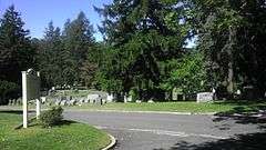
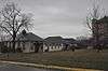
| 1 |
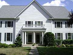
African Cemetery |
|
000000002003-10-03-0000October 3, 2003
(#03000999) |
North St.
40°58′34″N 73°42′12″W / 40.976111°N 73.703333°W / 40.976111; -73.703333 (African Cemetery) |
Rye |
Historic segregated cemetery, established in 1860 and used until 1964, including burial of veterans from the Civil War through World War II
|
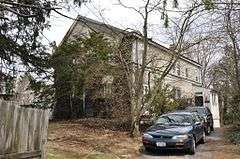
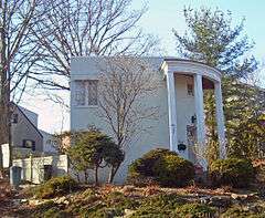
| 2 |
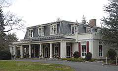
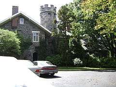
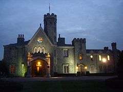
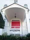
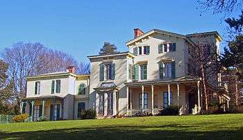
Armour-Stiner House |
|
000000001975-12-18-0000December 18, 1975
(#75001238) |
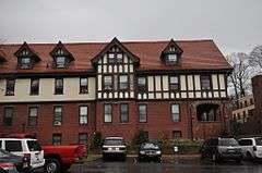
45 W. Clinton Ave.
41°01′51″N 73°52′16″W / 41.030833°N 73.871111°W / 41.030833; -73.871111 (Armour-Stiner House) |
Irvington |
Possibly the only domed octagon house in the world
|
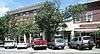
| 3 |
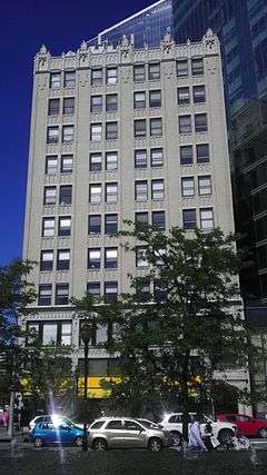
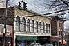
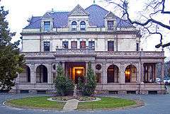
Bar Building |
|
000000002007-05-17-0000May 17, 2007
(#07000331) |
199 Main St.
41°01′57″N 73°46′05″W / 41.0325°N 73.768056°W / 41.0325; -73.768056 (Bar Building) |
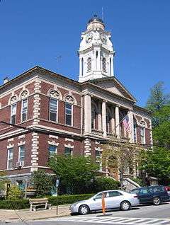
White Plains |
|
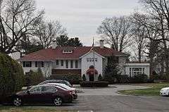
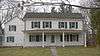
| 4 |
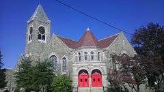
Bird Homestead |
|
000000002010-02-22-0000February 22, 2010
(#10000032) |
600 Milton Rd.
40°57′34″N 73°41′21″W / 40.959583°N 73.689214°W / 40.959583; -73.689214 (Bird Homestead) |
Rye |
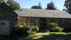
Original Greek Revival home built in 1835 with several farm buildings of the Bird family
|
| 5 |
Bolton Priory |
|
000000001974-06-28-0000June 28, 1974
(#74001320) |
7 Priory Lane
40°53′13″N 73°47′45″W / 40.886944°N 73.795833°W / 40.886944; -73.795833 (Bolton Priory) |
Pelham Manor |
|
| 6 |
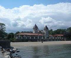
Evangeline Booth House |
Upload image |
000000002011-02-22-0000February 22, 2011
(#11000040) |
101 N. Central Ave.
41°01′12″N 73°47′50″W / 41.02°N 73.797222°W / 41.02; -73.797222 (Evangeline Booth House) |
Hartsdale |
|
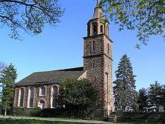
| 7 |
Boston Post Road Historic District |
|
000000001982-10-29-0000October 29, 1982
(#82001275) |
Roughly bounded by Boston Post Rd. and Milton Harbor
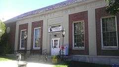
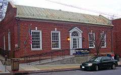
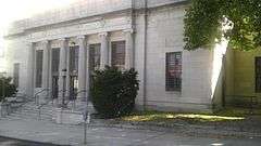
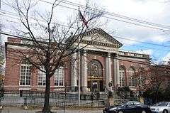
40°57′17″N 73°42′01″W / 40.954722°N 73.700278°W / 40.954722; -73.700278 (Boston Post Road Historic District) |
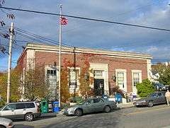
Rye |
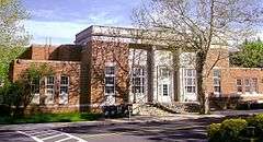
Houses and land use unchanged from late 18th century
|
| 8 |
Bronx River Parkway Reservation |
|
000000001991-01-11-0000January 11, 1991
(#90002143) |
Bronx River Pkwy. from jct. with Sprain Brook Rd. to and including Kensico Dam Plaza
41°00′59″N 73°47′47″W / 41.016389°N 73.796389°W / 41.016389; -73.796389 (Bronx River Parkway Reservation) |
Valhalla and Bronxville |
|
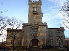
| 9 |
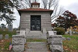
Bronxville Women's Club |
|
000000002007-10-03-0000October 3, 2007
(#07001041) |
135 Midland Ave.
40°56′30″N 73°49′35″W / 40.9418°N 73.8265°W / 40.9418; -73.8265 (Bronxville Women's Club) |
Bronxville |
|
| 10 |
Bush-Lyon Homestead |
|
000000001982-04-22-0000April 22, 1982
(#82003412) |
John Lyon Park, King St.
41°00′48″N 73°40′03″W / 41.0133°N 73.6675°W / 41.0133; -73.6675 (Bush-Lyon Homestead) |
Port Chester |
|
| 11 |
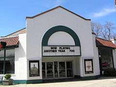
Capitol Theater |
|
000000001984-06-07-0000June 7, 1984
(#84003426) |
147-151 Westchester Ave.
41°00′06″N 73°39′56″W / 41.0017°N 73.6656°W / 41.0017; -73.6656 (Capitol Theater) |
Port Chester |
|
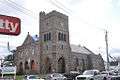
| 12 |
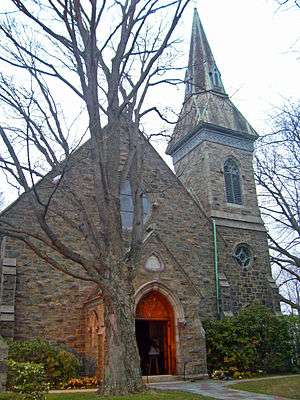
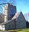
Church of St. Barnabas |
|
000000002000-03-24-0000March 24, 2000
(#00000241) |
15 N Broadway
41°02′23″N 73°51′57″W / 41.039722°N 73.865833°W / 41.039722; -73.865833 (Church of St. Barnabas) |
Irvington |
1853 stone Gothic Revival church has included Washington Irving, Philip Schuyler and Jay Gould as members
|
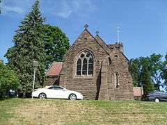
| 13 |
Church of St. Joseph of Arimathea |
|
000000002002-01-11-0000January 11, 2002
(#01001439) |
2172 Saw Mill River Rd.
41°02′37″N 73°49′46″W / 41.04359°N 73.82944°W / 41.04359; -73.82944 (Church of St. Joseph of Arimathea) |
Greenburgh |
|
| 14 |
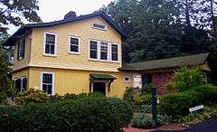
Jasper F. Cropsey House and Studio |
|
000000001973-05-17-0000May 17, 1973
(#73001287) |
49 Washington Ave.
40°59′35″N 73°52′55″W / 40.993056°N 73.88194°W / 40.993056; -73.88194 (Jasper F. Cropsey House and Studio) |
Hastings-on-Hudson |
|
| 15 |
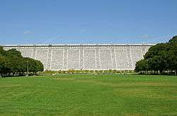
Old Croton Aqueduct |
|
000000001974-12-02-0000December 2, 1974
(#74001324) |
Runs N from Yonkers to New Croton Dam
41°00′52″N 73°53′14″W / 41.014444°N 73.887222°W / 41.014444; -73.887222 (Old Croton Aqueduct) |
Various |
First long-distance aqueduct built to provide water from upstate to New York City. An engineering marvel in its time now used as a linear park
|
| 16 |
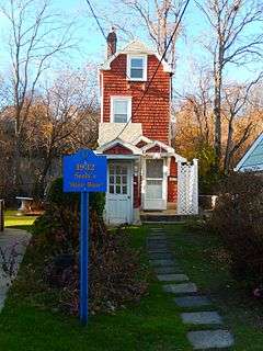
John William Draper House |
|
000000001975-05-15-0000May 15, 1975
(#75001237) |
407 Broadway
40°59′29″N 73°52′47″W / 40.991389°N 73.879722°W / 40.991389; -73.879722 (John William Draper House) |
Hastings-on-Hudson |
Home of astrophotography pioneer John William Draper, who in the 1840s took the first recognizable photo of the moon through a telescope at his observatory here.
|
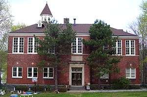
| 17 |
East Irvington School |
|
000000001983-10-06-0000October 6, 1983
(#83004216) |
Taxter Rd.
41°02′46″N 73°51′21″W / 41.046111°N 73.855833°W / 41.046111; -73.855833 (East Irvington School) |
East Irvington |
Late 19th-century school built for children of growing Irish immigrant population; now apartments.
|
| 18 |
Edgewood House |
|
000000001986-06-26-0000June 26, 1986
(#86001388) |
908 Edgewood Ave.
40°53′41″N 73°49′13″W / 40.894722°N 73.820278°W / 40.894722; -73.820278 (Edgewood House) |
Pelham Manor |
|
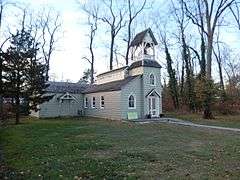
| 19 |
Elmsford Reformed Church and Cemetery |
|
000000001983-09-15-0000September 15, 1983
(#83001828) |
30 S. Central Ave.
41°03′14″N 73°49′15″W / 41.053889°N 73.820833°W / 41.053889; -73.820833 (Elmsford Reformed Church and Cemetery) |
Elmsford |
Congregation organized in 1790; church building erected three years later is oldest building in village and oldest church in continuous use in county
|
| 20 |
Estherwood and Carriage House |
|
000000001979-11-20-0000November 20, 1979
(#79001646) |
Clinton Ave.
41°00′46″N 73°52′21″W / 41.012778°N 73.8725°W / 41.012778; -73.8725 (Estherwood and Carriage House) |
Dobbs Ferry |
Late 19th-century mansion and estate of industrial tycoon James Jenning McComb; now part of The Masters School, which he helped endow.
|
| 21 |
First United Methodist Church |
|
000000002000-01-07-0000January 7, 2000
(#99001656) |
226 E. Lincoln Ave.
40°55′06″N 73°49′47″W / 40.918333°N 73.829722°W / 40.918333; -73.829722 (First United Methodist Church) |
Mount Vernon |
|
| 22 |
Leo Friedlander Studio |
|
000000001982-07-29-0000July 29, 1982
(#82003416) |
825 W. Hartsdale Rd.
41°02′35″N 73°48′34″W / 41.043056°N 73.809444°W / 41.043056; -73.809444 (Leo Friedlander Studio) |
Greenburgh |
|
| 23 |
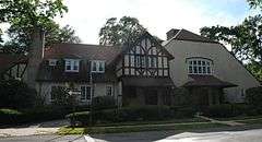
Glenwolde Park Historic District |
Upload image |
000000002014-09-03-0000September 3, 2014
(#14000542) |
Glenwolde Park, Walter St. & Willowbrook Ave.
41°03′32″N 73°51′40″W / 41.058959°N 73.8611417°W / 41.058959; -73.8611417 (Glenwolde Park Historic District) |
Tarrytown |
Tudor-styled residential district built during 1920s suburbanization
|
| 24 |
Good Counsel Complex |
|
000000001997-04-25-0000April 25, 1997
(#97000358) |
52 N. Broadway
41°02′21″N 73°45′52″W / 41.039167°N 73.764444°W / 41.039167; -73.764444 (Good Counsel Complex) |
White Plains |
|
| 25 |
Percy Grainger Home and Studio |
|
000000001993-04-08-0000April 8, 1993
(#93000234) |
7 Cromwell Pl.
41°01′38″N 73°46′02″W / 41.027222°N 73.767222°W / 41.027222; -73.767222 (Percy Grainger Home and Studio) |
White Plains |
|
| 26 |
Hadden-Margolis House |
Upload image |
000000002008-03-07-0000March 7, 2008
(#08000146) |
61 Winfield Ln.
40°58′19″N 73°44′16″W / 40.971878°N 73.737672°W / 40.971878; -73.737672 (Hadden-Margolis House) |
Harrison |
|
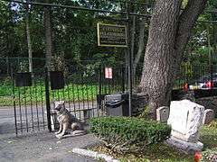
| 27 |
Hartsdale Pet Cemetery |
|
000000002012-08-17-0000August 17, 2012
(#12000535) |
75 N. Central Park Ave.
41°01′17″N 73°47′49″W / 41.021501°N 73.796929°W / 41.021501; -73.796929 (Hartsdale Pet Cemetery) |
Hartsdale |
|
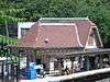
| 28 |
Hartsdale Railroad Station |
|
000000002011-07-14-0000July 14, 2011
(#11000453) |
1 E. Hartsdale Ave.
41°00′40″N 73°47′45″W / 41.0112°N 73.7958°W / 41.0112; -73.7958 (Hartsdale Railroad Station) |
Hartsdale |
1915 railroad station building
|
| 29 |
Hastings Prototype House |
|
000000001991-12-19-0000December 19, 1991
(#91001873) |
546 Farragut Pkwy.
40°59′04″N 73°52′17″W / 40.984444°N 73.871389°W / 40.984444; -73.871389 (Hastings Prototype House) |
Hastings-on-Hudson |
1936 Moderne house, built by local developer, was meant to be pattern for a housing development in Florida that was never built. Architect's only work in this style.
|
| 30 |
Widow Haviland's Tavern |
|
000000001974-04-16-0000April 16, 1974
(#74001322) |
Purchase St.
40°58′55″N 73°41′05″W / 40.981944°N 73.684722°W / 40.981944; -73.684722 (Widow Haviland's Tavern) |
Rye |
|
| 31 |
Caleb Hyatt House |
|
000000001973-01-22-0000January 22, 1973
(#73001291) |
937 White Plains Post Rd.
40°58′54″N 73°48′00″W / 40.98167°N 73.8001°W / 40.98167; -73.8001 (Caleb Hyatt House) |
Scarsdale |
|
| 32 |
Hyatt-Livingston House |
Upload image |
000000001972-10-05-0000October 5, 1972
(#72000917) |
152 Broadway
41°00′32″N 73°52′45″W / 41.008889°N 73.879167°W / 41.008889; -73.879167 (Hyatt-Livingston House) |
Dobbs Ferry |
Burned down in 1974
|
| 33 |
Irvington Historic District |
|
000000002014-01-15-0000January 15, 2014
(#13001095) |
N. & S. Astor, Broadway, Buckhout, Cottenet, Dearman, Dutcher, Eckar & Ferris Sts., Bridge St., E. & W. Home Pl.
41°02′21″N 73°52′20″W / 41.0392731°N 73.8723192°W / 41.0392731; -73.8723192 (Irvington Historic District) |
Irvington |
Historic core of small riverside suburb; See map
|
| 34 |
Irvington Town Hall |
|
000000001984-11-01-0000November 1, 1984
(#84000205) |
85 Main St.
41°02′25″N 73°52′06″W / 41.040278°N 73.868333°W / 41.040278; -73.868333 (Irvington Town Hall) |
Irvington |
Built in 1902, early use of Colonial Revival in a civic building. Upper floors have an auditorium for performances and community gatherings, was home to public library until 2000.
|
| 35 |
Timothy Knapp House and Milton Cemetery |
|
000000001982-06-14-0000June 14, 1982
(#82003413) |
265 Rye Beach Ave. and Milton Rd.
40°57′53″N 73°41′12″W / 40.964722°N 73.686667°W / 40.964722; -73.686667 (Timothy Knapp House and Milton Cemetery) |
Rye |
Built between 1667 and 1670 by Timothy Knapp
|
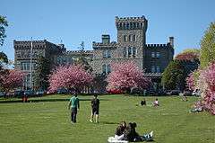
| 36 |
Lawrence Park Historic District |
Upload image |
000000001980-01-23-0000January 23, 1980
(#80002788) |
Roughly bounded by Side Hill, Prescott, Kensington, Garden and Chestnut Ave., Maidens Ln., and Valley and Pondfield Rds.
40°56′27″N 73°50′19″W / 40.940833°N 73.838611°W / 40.940833; -73.838611 (Lawrence Park Historic District) |
Bronxville |
|
| 37 |
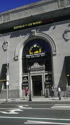
Life Savers Building |
|
000000001985-07-11-0000July 11, 1985
(#85001496) |
N. Main St.
41°00′20″N 73°39′52″W / 41.0056°N 73.6644°W / 41.0056; -73.6644 (Life Savers Building) |
Port Chester |
Now a condominium complex
|
| 38 |
Lord and Burnham Building |
|
000000001999-02-12-0000February 12, 1999
(#99000193) |
2 Main St.
41°02′22″N 73°52′23″W / 41.039444°N 73.873056°W / 41.039444; -73.873056 (Lord and Burnham Building) |
Irvington |
1870 building, home to eponymous maker of conservatories and greenhouses that supplied local estates, is now the village's library after lengthy restoration.
|
| 39 |
Mamaroneck Methodist Church |
|
000000001992-10-02-0000October 2, 1992
(#92001304) |
514 Boston Post Rd.
40°57′05″N 73°43′48″W / 40.951389°N 73.73°W / 40.951389; -73.73 (Mamaroneck Methodist Church) |
Mamaroneck |
|
| 40 |
Manor Club |
|
000000002014-05-12-0000May 12, 2014
(#14000207) |
1023 Esplanade
40°53′30″N 73°48′14″W / 40.891535°N 73.80378°W / 40.891535; -73.80378 (Manor Club) |
Pelham Manor |
|
| 41 |
Mapleton |
|
000000001976-09-28-0000September 28, 1976
(#76001295) |
52 N. Broadway
41°02′18″N 73°45′54″W / 41.038333°N 73.765°W / 41.038333; -73.765 (Mapleton) |
White Plains |
|
| 42 |
Marble Schoolhouse |
|
000000002005-07-06-0000July 6, 2005
(#05000663) |
388 California Rd.
40°55′53″N 73°48′41″W / 40.931389°N 73.811389°W / 40.931389; -73.811389 (Marble Schoolhouse) |
Eastchester |
|
| 43 |
Masterton-Dusenberry House |
|
000000001980-04-16-0000April 16, 1980
(#80002789) |
90 White Plains Rd.
40°56′13″N 73°49′06″W / 40.9369°N 73.8182°W / 40.9369; -73.8182 (Masterton-Dusenberry House) |
Bronxville |
|
| 44 |
McVickar House |
|
000000002004-01-14-0000January 14, 2004
(#03001398) |
131 Main St.
41°02′20″N 73°51′57″W / 41.038944°N 73.865847°W / 41.038944; -73.865847 (McVickar House) |
Irvington |
1853 Greek Revival house is second oldest on village's Main Street
|
| 44.5 |
New York, Westchester & Boston Railway Highbrook Avenue Bridge |
Upload image |
000000002016-08-02-0000August 2, 2016
(#16000487) |
Highbrook Ave. between Lincoln & Harmon Aves
Coordinates missing |
Pelham |
Early example of a reinforced concrete arch bridge, dating to 1911
|
| 45 |
Nuits |
|
000000001977-04-13-0000April 13, 1977
(#77000986) |
Hudson Rd. and Clifton Pl.
41°01′29″N 73°52′31″W / 41.024722°N 73.875278°W / 41.024722; -73.875278 (Nuits) |
Ardsley-on-Hudson |
1852 Italian villa-style house was early work by Detlef Lienau; later home to Cyrus West Field and John Jacob Astor III. Only extant example of Lienau's early residential work.
|
| 46 |
Odell House |
Upload image |
000000001973-03-28-0000March 28, 1973
(#73001286) |
425 Ridge Rd.
41°01′10″N 73°49′04″W / 41.019444°N 73.817778°W / 41.019444; -73.817778 (Odell House) |
Greenburgh |
|
| 47 |
Pelham Picture House |
|
000000002010-05-28-0000May 28, 2010
(#10000305) |
175 Wolf's Lane
40°54′26″N 73°48′41″W / 40.907311°N 73.811389°W / 40.907311; -73.811389 (Pelham Picture House) |
Pelham |
|
| 48 |
Pelhamdale |
|
000000001982-11-04-0000November 4, 1982
(#82001276) |
45 Iden Ave.
40°54′03″N 73°48′55″W / 40.900833°N 73.815278°W / 40.900833; -73.815278 (Pelhamdale) |
Pelham Manor |
|
| 49 |
Peoples National Bank and Trust Company Building |
|
000000002000-09-14-0000September 14, 2000
(#00001119) |
31 Mamaroneck Ave.
41°01′54″N 73°46′00″W / 41.031667°N 73.766667°W / 41.031667; -73.766667 (Peoples National Bank and Trust Company Building) |
White Plains |
|
| 50 |
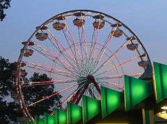
Playland Amusement Park |
|
000000001980-07-04-0000July 4, 1980
(#80004529) |
Playland Pkwy. and Forest Ave.
40°58′08″N 73°40′17″W / 40.968889°N 73.671389°W / 40.968889; -73.671389 (Playland Amusement Park) |
Rye |
Only publicly owned amusement park in U.S. and an early example of one designed for visitors by car as opposed to public transit; Art Deco stylings on attractions widely copied
|
| 51 |
Presbyterian Rest for Convalescents |
|
000000002011-04-27-0000April 27, 2011
(#11000230) |
69 N. Broadway
41°02′19″N 73°46′03″W / 41.038594°N 73.76752°W / 41.038594; -73.76752 (Presbyterian Rest for Convalescents) |
White Plains |
|
| 52 |
Jacob Purdy House |
|
000000001979-08-31-0000August 31, 1979
(#79001651) |
60 Park Ave.
41°02′12″N 73°46′26″W / 41.036667°N 73.773889°W / 41.036667; -73.773889 (Jacob Purdy House) |
White Plains |
|
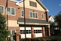
| 53 |
Putnam and Mellor Engine and Hose Company Firehouse |
|
000000001983-09-15-0000September 15, 1983
(#83001831) |
46 S. Main St.
40°59′58″N 73°39′55″W / 40.9994°N 73.6653°W / 40.9994; -73.6653 (Putnam and Mellor Engine and Hose Company Firehouse) |
Port Chester |
Torn down in 2007
|
| 54 |
Reid Hall, Manhattanville College |
|
000000001974-03-22-0000March 22, 1974
(#74001321) |
Manhattanville College, Purchase St.
41°01′56″N 73°42′58″W / 41.032222°N 73.716111°W / 41.032222; -73.716111 (Reid Hall, Manhattanville College) |
Purchase |
|
| 55 |
Romer-Van Tassel House |
Upload image |
000000001994-11-25-0000November 25, 1994
(#94001373) |
2121 Saw Mill River Rd.
41°02′39″N 73°49′40″W / 41.044167°N 73.827778°W / 41.044167; -73.827778 (Romer-Van Tassel House) |
Greenburgh |
|
| 56 |
Rye Meeting House |
|
000000002011-01-14-0000January 14, 2011
(#10001134) |
624 Milton Rd.
40°57′31″N 73°41′20″W / 40.958611°N 73.688889°W / 40.958611; -73.688889 (Rye Meeting House) |
Rye |
Original one room school house built in the 1830s, used as a chapel and later as a Quaker meeting house. Built in the Gothic Revival style.
|
| 57 |
Rye Town Park-Bathing Complex and Oakland Beach |
|
000000002003-04-18-0000April 18, 2003
(#03000252) |
Forrest Ave., bet. Rye Beach and Dearborn Ave.
40°57′39″N 73°40′45″W / 40.960833°N 73.679167°W / 40.960833; -73.679167 (Rye Town Park-Bathing Complex and Oakland Beach) |
Rye |
|
| 58 |
St. Paul's Church National Historic Site |
|
000000001966-10-15-0000October 15, 1966
(#66000580) |
Eastchester
40°53′36″N 73°49′33″W / 40.893383°N 73.825767°W / 40.893383; -73.825767 (St. Paul's Church National Historic Site) |
Mount Vernon |
|
| 59 |
St. Peter's Episcopal Church |
|
000000002006-04-12-0000April 12, 2006
(#06000260) |
19 Smith St.
41°00′14″N 73°40′01″W / 41.0039°N 73.6669°W / 41.0039; -73.6669 (St. Peter's Episcopal Church) |
Port Chester |
|
| 60 |
St. Thomas' Episcopal Church Complex |
|
000000002003-08-12-0000August 12, 2003
(#03000242) |
158-168 W. Boston Post Rd.
40°56′53″N 73°44′07″W / 40.948056°N 73.735278°W / 40.948056; -73.735278 (St. Thomas' Episcopal Church Complex) |
Mamaroneck |
|
| 61 |
Scarsdale Railroad Station |
|
000000002000-07-27-0000July 27, 2000
(#00000837) |
Popham Rd. at Bronx River Pkwy.
40°59′22″N 73°48′32″W / 40.989444°N 73.808889°W / 40.989444; -73.808889 (Scarsdale Railroad Station) |
Scarsdale |
|
| 62 |
Scarsdale Woman's Club |
|
000000002008-02-29-0000February 29, 2008
(#08000110) |
37 Drake Rd.
40°59′14″N 73°47′36″W / 40.9871°N 73.7932°W / 40.9871; -73.7932 (Scarsdale Woman's Club) |
Scarsdale |
|
| 63 |
Skinny House |
|
000000002015-05-18-0000May 18, 2015
(#15000235) |
175 Grand St.
40°57′17″N 73°44′33″W / 40.95486°N 73.74238°W / 40.95486; -73.74238 (Skinny House) |
Mamaroneck |
Depression-era house built by African-American architect on small parcel
|
| 64 |
Soundview Manor |
|
000000002009-11-25-0000November 25, 2009
(#09000957) |
283 Soundview Ave.
41°00′15″N 73°45′55″W / 41.0043°N 73.7653°W / 41.0043; -73.7653 (Soundview Manor) |
White Plains |
|
| 65 |
South Presbyterian Church |
|
000000002000-05-26-0000May 26, 2000
(#00000548) |
343 Broadway
41°00′53″N 73°52′22″W / 41.014722°N 73.872778°W / 41.014722; -73.872778 (South Presbyterian Church) |
Dobbs Ferry |
1869 stone Gothic Revival church is the only known building by Julius Munckowitz, later involved in developing New York City's park system
|
| 66 |
Spanish American War Monument to the 71st Infantry Regiment |
|
000000002011-01-14-0000January 14, 2011
(#10001133) |
Jackson Avenue & Saw Mill River Road
41°00′38″N 73°51′50″W / 41.01068°N 73.863788°W / 41.01068; -73.863788 (Spanish American War Monument to the 71st Infantry Regiment) |
Greenburgh |
|
| 67 |
John Stevens House |
|
000000001972-04-26-0000April 26, 1972
(#72000919) |
29 W. 4th St.
40°54′15″N 73°50′08″W / 40.904167°N 73.835556°W / 40.904167; -73.835556 (John Stevens House) |
Mount Vernon |
|
| 68 |
Stony Hill Cemetery |
Upload image |
000000001999-06-25-0000June 25, 1999
(#99000753) |
Buckout Rd.
41°03′18″N 73°44′59″W / 41.055°N 73.749722°W / 41.055; -73.749722 (Stony Hill Cemetery) |
Harrison |
|
| 69 |
Trinity Episcopal Church Complex |
|
000000001998-09-01-0000September 1, 1998
(#97001494) |
335 Fourth Ave.
40°54′11″N 73°50′02″W / 40.903056°N 73.833889°W / 40.903056; -73.833889 (Trinity Episcopal Church Complex) |
Mount Vernon |
|
| 70 |
Tuckahoe High School |
|
000000002010-02-24-0000February 24, 2010
(#10000045) |
65 Siwanoy Blvd.
40°56′31″N 73°48′49″W / 40.942°N 73.813578°W / 40.942; -73.813578 (Tuckahoe High School) |
Eastchester |
|
| 71 |
US Post Office-Bronxville |
|
000000001988-11-17-0000November 17, 1988
(#88002459) |
119 Pondfield Rd.[5]
40°56′18″N 73°49′57″W / 40.938333°N 73.8325°W / 40.938333; -73.8325 (US Post Office-Bronxville) |
Bronxville |
part of the US Post Offices in New York State, 1858-1943, TR
|
| 72 |
US Post Office-Dobbs Ferry |
|
000000001988-11-17-0000November 17, 1988
(#88002484) |
120 Main St.[6]
41°00′55″N 73°52′30″W / 41.015278°N 73.875°W / 41.015278; -73.875 (US Post Office-Dobbs Ferry) |
Dobbs Ferry |
One of many New Deal-era Colonial Revival post offices in the state; one of only three with parapeted gables and window keystones; part of the US Post Offices in New York State, 1858-1943, TR
|
| 73 |
US Post Office-Harrison |
|
000000001989-05-11-0000May 11, 1989
(#88002524) |
258 Halstead Ave.
40°58′07″N 73°42′51″W / 40.968611°N 73.714167°W / 40.968611; -73.714167 (US Post Office-Harrison) |
Harrison |
part of the US Post Offices in New York State, 1858-1943, TR
|
| 74 |
US Post Office-Larchmont |
|
000000001989-05-11-0000May 11, 1989
(#88002341) |
1 Chatsworth Ave.
40°55′48″N 73°45′05″W / 40.93°N 73.751389°W / 40.93; -73.751389 (US Post Office-Larchmont) |
Larchmont |
part of the US Post Offices in New York State, 1858-1943, TR
|
| 75 |
US Post Office-Mount Vernon |
|
000000001989-05-11-0000May 11, 1989
(#88002355) |
15 S. First St.
40°54′40″N 73°50′02″W / 40.911111°N 73.833889°W / 40.911111; -73.833889 (US Post Office-Mount Vernon) |
Mount Vernon |
part of the US Post Offices in New York State, 1858-1943, TR
|
| 76 |
US Post Office-Port Chester |
|
000000001989-05-11-0000May 11, 1989
(#88002406) |
245 Westchester Ave.
41°00′12″N 73°40′07″W / 41.0032°N 73.6686°W / 41.0032; -73.6686 (US Post Office-Port Chester) |
Port Chester |
part of the US Post Offices in New York State, 1858-1943, TR
|
| 77 |
US Post Office-Rye |
|
000000001989-05-11-0000May 11, 1989
(#88002426) |
41 Purdy Ave.
40°59′04″N 73°40′59″W / 40.98445°N 73.6830°W / 40.98445; -73.6830 (US Post Office-Rye) |
Rye |
part of the US Post Offices in New York State, 1858-1943, TR
|
| 78 |
US Post Office-Scarsdale |
|
000000001989-05-11-0000May 11, 1989
(#88002428) |
29 Chase Rd.[7]
40°59′24″N 73°48′22″W / 40.9900°N 73.8062°W / 40.9900; -73.8062 (US Post Office-Scarsdale) |
Scarsdale |
part of the US Post Offices in New York State, 1858-1943, TR
|
| 79 |
Villa Lewaro |
|
000000001976-05-11-0000May 11, 1976
(#76001289) |
N. Broadway
41°02′00″N 73°51′56″W / 41.033333°N 73.865556°W / 41.033333; -73.865556 (Villa Lewaro) |
Irvington |
Home of Madame C.J. Walker, hair-care products tycoon and first African-American millionaire.
|
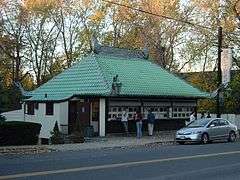
| 80 |
Walter's Hot Dog Stand |
|
000000002010-06-11-0000June 11, 2010
(#10000338) |
937 Palmer Ave.
40°56′35″N 73°44′49″W / 40.942977°N 73.746940°W / 40.942977; -73.746940 (Walter's Hot Dog Stand) |
Mamaroneck |
1928 imitation pagoda
|
| 81 |
William E. Ward House |
|
000000001976-11-07-0000November 7, 1976
(#76001294) |
Comly Ave.
41°01′34″N 73°40′03″W / 41.026111°N 73.6675°W / 41.026111; -73.6675 (William E. Ward House) |
Rye Brook |
First reinforced concrete structure in U.S., built in the 1870s on state line. Extends into Greenwich, Connecticut
|
| 82 |
Washington Irving Memorial |
|
000000002000-09-08-0000September 8, 2000
(#00001062) |
Broadway and Sunnyside Ln.
41°02′53″N 73°51′43″W / 41.048056°N 73.861944°W / 41.048056; -73.861944 (Washington Irving Memorial) |
Irvington |
Daniel Chester French-sculpted memorial to writer who gave Irvington its name, erected in the late 1920s.
|
| 83 |
Wayside Cottage |
Upload image |
000000001981-05-01-0000May 1, 1981
(#81000418) |
1039 Post Rd.
40°59′32″N 73°47′40″W / 40.992222°N 73.794444°W / 40.992222; -73.794444 (Wayside Cottage) |
Scarsdale |
|
| 84 |
White Plains Armory |
|
000000001980-04-16-0000April 16, 1980
(#80002796) |
35 S. Broadway
41°01′53″N 73°45′47″W / 41.031389°N 73.763056°W / 41.031389; -73.763056 (White Plains Armory) |
White Plains |
|
| 85 |
White Plains Rural Cemetery |
|
000000002003-09-19-0000September 19, 2003
(#03000247) |
167 N. Broadway
41°02′50″N 73°46′20″W / 41.047222°N 73.772222°W / 41.047222; -73.772222 (White Plains Rural Cemetery) |
White Plains |
|
| 86 |
Albert E. and Emily Wilson House |
|
000000002007-04-18-0000April 18, 2007
(#07000330) |
617 Brook St.
40°57′16″N 73°43′46″W / 40.954444°N 73.729444°W / 40.954444; -73.729444 (Albert E. and Emily Wilson House) |
Mamaroneck |
|
| 87 |
Woman's Club of White Plains |
|
000000002010-10-20-0000October 20, 2010
(#10000853) |
305 Ridgeway
41°00′23″N 73°44′54″W / 41.0063°N 73.7484°W / 41.0063; -73.7484 (Woman's Club of White Plains) |
White Plains |
|


.tif.jpg)


.jpg)