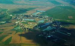
Nahala, Israel
This article is about the moshav in Israel. For the region in Iraq, see Nahla, Iraq.
| Nahala נַחֲלָה | |
|---|---|
 | |
 Nahala | |
| Coordinates: 31°39′33.11″N 34°47′39.11″E / 31.6591972°N 34.7941972°ECoordinates: 31°39′33.11″N 34°47′39.11″E / 31.6591972°N 34.7941972°E | |
| District | Southern |
| Council | Yoav |
| Affiliation | Moshavim Movement |
| Founded | 1953 |
| Population (2015)[1] | 588 |
Nahala (Hebrew: נַחֲלָה, lit. Estate) is a moshav in south-central Israel. Located a few kilometers north of Kiryat Gat and south of Kiryat Malakhi., it falls under the jurisdiction of Yoav Regional Council. In 2015 it had a population of 588.
History
The community was founded in 1953 by immigrants to Israel from Yemen on land belonging to the Arab village of Summeil, which was depopulated in the 1948 Arab–Israeli War.,[2] but today contains a mixed population. Along with the neighboring Menuha, it was named for the Menuha VeNahala (Hebrew: מנוחה ונחלה) organization that founded Rehovot.
References
| Wikimedia Commons has media related to Nahala. |
- ↑ "List of localities, in Alphabetical order" (PDF). Israel Central Bureau of Statistics. Retrieved 16 October 2016.
- ↑ Khalidi, Walid (1992), All That Remains: The Palestinian Villages Occupied and Depopulated by Israel in 1948, Washington D.C.: Institute for Palestine Studies, p. 137, ISBN 0-88728-224-5
This article is issued from Wikipedia - version of the 9/20/2016. The text is available under the Creative Commons Attribution/Share Alike but additional terms may apply for the media files.