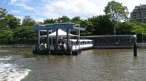
Mowbray Park ferry wharf
Mowbray Park | |||||||||||
|---|---|---|---|---|---|---|---|---|---|---|---|
 | |||||||||||
| Location | Park Avenue, East Brisbane[1] | ||||||||||
| Coordinates | 27°28′39″S 153°02′35″E / 27.4775°S 153.0431°ECoordinates: 27°28′39″S 153°02′35″E / 27.4775°S 153.0431°E | ||||||||||
| Owned by | Brisbane City Council | ||||||||||
| Construction | |||||||||||
| Parking | Yes | ||||||||||
| Disabled access | Yes | ||||||||||
| Other information | |||||||||||
| Fare zone | 2 (TransLink) | ||||||||||
| Services | |||||||||||
| |||||||||||
Mowbray Park is a ferry wharf in the suburb of East Brisbane in Brisbane, Queensland, Australia. It is used by the CityCat on the Brisbane River.
The wharf takes its name from adjacent Mowbray Park, which in turn is named for Thomas Mowbray, a Presbyterian minister who had been minister at the now heritage-listed Mowbraytown Presbyterian Church in the East Brisbane area (and formerly of the Blackridge Parish Church, Scotland).[2]
In January 2011 the wharf sustained a moderate damage during the devastating floods;[3][4] it was repaired and reopened on 14 February 2011.[5]
References
- ↑ Brisbane Datastore (2012-02-09), Ferry Terminals, Brisbane City Council, retrieved 2013-11-03
- ↑ "Mowbraytown Presbyterian Church Group (entry 601219)". Queensland Heritage Register. Queensland Heritage Council. Retrieved 1 August 2014.
- ↑ "List: CityCat, CityFerry terminal damage". Brisbane Times. January 20, 2011. Retrieved 27 January 2011.
- ↑ "CityCat service set for fast return". Brisbane Times. February 1, 2011. Retrieved 2 February 2011.
- ↑ "January 2011 flood event - CityCat and CityFerry services". Brisbane City Council. Retrieved 14 February 2011.
External links
| Wikimedia Commons has media related to Mowbray Park ferry wharf. |
This article is issued from Wikipedia - version of the 11/17/2016. The text is available under the Creative Commons Attribution/Share Alike but additional terms may apply for the media files.