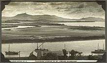
Mount Larcom, Queensland
| Mount Larcom Queensland | |||||||||||||
|---|---|---|---|---|---|---|---|---|---|---|---|---|---|
|
Gladstone Street, 2014 | |||||||||||||
 Mount Larcom | |||||||||||||
| Coordinates | 23°48′37″S 150°58′42″E / 23.81028°S 150.97833°ECoordinates: 23°48′37″S 150°58′42″E / 23.81028°S 150.97833°E | ||||||||||||
| Population | 278 (2011 census)[1] | ||||||||||||
| Postcode(s) | 4695 | ||||||||||||
| Location | |||||||||||||
| LGA(s) | Gladstone Regional Council | ||||||||||||
| State electorate(s) | Gladstone | ||||||||||||
| Federal Division(s) | Flynn | ||||||||||||
| |||||||||||||
Mount Larcom is the name of a mountain, a township and a locality in the Gladstone Region, Queensland, Australia.[2][3][4] The township/locality is at the junction of the Bruce Highway and Port Curtis Way approximately 70 kilometres (43 mi) south of the city of Rockhampton. At the 2011 census, Mount Larcom had a population of 278.[1]
History
Commander Matthew Flinders named Mount Larcom (the mountain) on 4 August 1802, after a Royal Navy colleague Captain Thomas Larcom.[2]
Mount Larcombe Provisional School opened on 13 November 1882, but closed for some time during the 1890s due to low student numbers. In 1909, it was upgraded to be Mount Larcombe State School and was renamed Mount Larcom State School in 1913. In 1964, a secondary department (Years 8-10) was added to the school.[5][6]
Mount Larcom Post Office opened by December 1909 (a receiving office had been open from 1904, first known as Mount Larcombe).[7]
On Sunday 16 July 1922 the Catholic church was opened by Bishop of Rockhampton Joseph Shiel. It was named for Our Lady of Mount Carmel. The land cost £64 and the church building cost £441.[8]
The first of Mount Larcom's annual agricultural shows was held on 8 October 1919. It was opened by George Carter, the Member of the Queensland Legislative Assembly for Port Curtis.[9]
The ambulance station first opened in 1924; its replacement opened on 20 December 2001.[10]
Heritage listings
Mount Larcom has a number of heritage-listed sites, including:
- 52780 Bruce Highway: Mount Larcombe Station Original Homestead Site [11]
- Popenia Road: Mount Larcom Cemetery [12]
- The Narrows Road: Mount Larcom Showground [13]
Geography

The mountain, rising to 631 metres (2,070 ft), is slightly east of the township and is a dominant feature on the horizon, especially from the town of Gladstone. It was named by Matthew Flinders after a Naval Captain that he served under.
Transport
Mount Larcom railway station is on the North Coast railway line, with long-distance passenger trains operated by Queensland Rail stopping here and a direct line to Gladstone.
Education
Mount Larcom State School is a government co-education primary school with a secondary department(P-10) located in Raglan Street. In 2013, the school had 89 pupils and 10 teachers. For high school education beyond Year 10, students must travel to other high schools; the nearest is in Gladstone.[14][15]
Amenities
The Mount Larcom Library is on Raglan Street; it is operated by the Gladstone Regional Council.[16]
There is a Catholic church, Our Lady of Mount Carmel, at 24 Balfour Street. Each month there is a mass and a lay-led liturgy.[17]
There is a public hall in Raglan Street.
Despite its small population, Mount Larcom has a police station (Gladstone Street), an ambulance station (Raglan Street), a volunteer Rural Fire Service and a volunteer State Emergency Service group. However, the nearest hospitals are in Gladstone and Rockhampton. Being located near the junction of two highways, a common emergency is vehicle crashes.[10]
Events
The Mount Larcom and District Show Society organise an annual agricultural show in June each year. In 2014, in addition to the livestock competitions, there are other activities including a ute muster, woodchopping and fireworks.[18]
References
- 1 2 Australian Bureau of Statistics (31 October 2012). "Mount Larcom (SSC)". 2011 Census QuickStats. Retrieved 20 April 2014.
- 1 2 "Mount Larcom (mountain) (entry 19010)". Queensland Place Names. Queensland Government. Retrieved 20 April 2014.
- ↑ "Mount Larcom (town) (entry 23063)". Queensland Place Names. Queensland Government. Retrieved 20 April 2014.
- ↑ "Mount Larcom (locality) (entry 46614)". Queensland Place Names. Queensland Government. Retrieved 20 April 2014.
- ↑ "Opening and closing dates of Queensland Schools". Queensland Government. Retrieved 26 June 2014.
- ↑ "Agency ID5532, Mount Larcom State School". Queensland State Archives. Retrieved 26 June 2014.
- ↑ Premier Postal History. "Post Office List". Premier Postal Auctions. Retrieved 10 May 2014.
- ↑ "NEW CATHOLIC CHURCHES.". The Morning Bulletin. Rockhampton, Qld.: National Library of Australia. 22 July 1922. p. 7. Retrieved 25 June 2014.
- ↑ "MT. LARCOM SHOW.". The Brisbane Courier. National Library of Australia. 13 October 1919. p. 8. Retrieved 26 June 2014.
- 1 2 "Mt Larcom Emergency Services". Mount Larcom Community. Retrieved 26 June 2014.
- ↑ "Mount Larcombe Station Original Homestead Site". Local Heritage Register. Gladstone Regional Council. Retrieved 26 June 2014.
- ↑ "Mount Larcom Cemetery". Local Heritage Register. Gladstone Regional Council. Retrieved 26 June 2014.
- ↑ "Mount Larcom Showground". Local Heritage Register. Gladstone Regional Council. Retrieved 26 June 2014.
- ↑ "Queensland State and Non-State Schools". Queensland Government. Retrieved 26 June 2014.
- ↑ "2013 School Annual Report" (PDF). Mount Larcom State School. Mount Larcom State School. Retrieved 26 June 2014.
- ↑ "Contact us". Gladstone Regional Libraries. Gladstone Regional Council. Retrieved 23 June 2014.
- ↑ "Gladstone Parish". Catholic Diocese of Rochampton. Roman Catholic Diocese of Rockhampton. Retrieved 24 June 2014.
- ↑ "Schedules". Mount Larcom and District Show Society. Mount Larcom and District Show Society. Retrieved 26 June 2014.
Further reading
- Tully, Judith; Mount Larcom State School Jubilee Committee (2007), Mount Larcom State School & Secondary Department 125th jubilee, 1882–2007, Jubilee Committee
- Queensland Ambulance Transport Brigade. Mt. Larcom Centre (1974), Queensland Ambulance Transport Brigade, Mount Larcom Centre : golden jubilee, 1924–1974, QATB
- Holborow, Janice (1999), Mount Larcom & District Show history 1919–1999, s.n
External links
| Wikimedia Commons has media related to Mount Larcom, Queensland. |