Monte di Procida
| Monte di Procida | ||
|---|---|---|
| Comune | ||
| Comune di Monte di Procida | ||
|
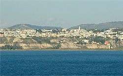
Monte di Procida seen from Procida Island | ||
| ||
 Monte di Procida Location of Monte di Procida in Italy | ||
| Coordinates: 40°48′N 14°3′E / 40.800°N 14.050°ECoordinates: 40°48′N 14°3′E / 40.800°N 14.050°E | ||
| Country | Italy | |
| Region | Campania | |
| Province / Metropolitan city | Naples (NA) | |
| Frazioni | Cappella, Miliscola, Torregaveta | |
| Government | ||
| • Mayor | Giuseppe Pugliese | |
| Area | ||
| • Total | 3.6 km2 (1.4 sq mi) | |
| Elevation | 63 m (207 ft) | |
| Population (31 December 2010[1]) | ||
| • Total | 13,341 | |
| • Density | 3,700/km2 (9,600/sq mi) | |
| Demonym(s) | Montesi | |
| Time zone | CET (UTC+1) | |
| • Summer (DST) | CEST (UTC+2) | |
| Postal code | 80070 | |
| Dialing code | 081 | |
| Patron saint | Assumption of Mary | |
| Saint day | August 15 | |
| Website | Official website | |
Monte di Procida is a small comune (municipality) in the Metropolitan City of Naples in the Italian region of Campania, located about 15 km west of Naples, facing the island of Procida. Monte di Procida includes the small island of San Martino, which was occupied by the Germans during World War II. Its territory is included in the Campi Flegrei Regional Park.
Twin towns
See also
References
- ↑ All demographics and other statistics: Italian statistical institute Istat.
- ↑ Twinning with Molise region after the Campi Flegrei emergency in 2001
This article is issued from Wikipedia - version of the 7/20/2016. The text is available under the Creative Commons Attribution/Share Alike but additional terms may apply for the media files.

