Minco, Oklahoma
| Minco, Oklahoma | |
|---|---|
| City | |
|
Location of Minco, Oklahoma | |
| Coordinates: 35°18′56″N 97°56′45″W / 35.31556°N 97.94583°WCoordinates: 35°18′56″N 97°56′45″W / 35.31556°N 97.94583°W | |
| Country | United States |
| State | Oklahoma |
| County | Grady |
| Area | |
| • Total | 12.3 sq mi (31.8 km2) |
| • Land | 12.3 sq mi (31.7 km2) |
| • Water | 0.0 sq mi (0.0 km2) |
| Elevation | 1,296 ft (395 m) |
| Population (2000) | |
| • Total | 1,672 |
| • Density | 136.5/sq mi (52.7/km2) |
| Time zone | Central (CST) (UTC-6) |
| • Summer (DST) | CDT (UTC-5) |
| ZIP code | 73059 |
| Area code(s) | 405 |
| FIPS code | 40-48750[1] |
| GNIS feature ID | 1095428[2] |
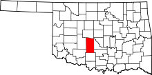
Minco is a city in Grady County, Oklahoma, United States. The population was 1,672 at the 2000 census.
History
The town was originally included in the Chickasaw Nation, and is believed to be named after the great Chickasaw chief and warrior, Itawamba Minco, who later acquired the name of Levi Colbert. A county in Mississippi is named after the chief who resided in nearby Monroe county near Cotton Gin Port.[3] Minco was originally settled sometime around 1890, several years before Oklahoma achieved statehood. In its early stages it was a very busy town because of its location at the end of the Chicago, Rock Island & Pacific Railroad Co. until the railroad was extended further south two years later.[4] Charles B. Campbell owned the occupancy rights of the land that the town was built on. His wife was Miss Maggie (Margaret) Williams, a daughter of W. G. (Caddo Bill) Williams, owner of the Half Moon Ranch, who started Silver City in 1872 by building a trading store for those cattlemen driving their herds of cattle up the Chisholm Trail.[4]
Before the establishment of Minco as a town three major expeditions passed through the area. The first expedition was conducted by Captain Randolph Marcy in 1849. Marcy was ordered to escort 1500 individuals headed to the California Gold Fields. When the expedition approached the Minco area they kept to the south side of Buggy Creek, which Marcy named Deer Creek. Marcy named his route the Fort Smith to Santa Fe Trail. Interestingly enough there was a road established in 1839-1840 on the north side of the Canadian River that was also named the Fort Smith to Santa Fe Trail. This road had been laid out by Josiah Gregg a Santa Fe merchant who had connections with merchants in Fort Smith, Arkansas.
During the summer of 1853 the first railroad survey was conducted from Fort Smith, Arkansas to Los Angeles California by Lt. Amiel Weeks Whipple. Whipple's Survey basically followed Marcy's route from Fort Smith until they reached the Caddo County Buttes. At that point the expedition moved westward while Marcy had turned north to join the Fort Smith to Santa Fe Trail not far north of Hydro, Oklahoma. Whipple continued westward leaving Oklahoma just west of the Antelope Hills in Rodger Mills County.
The Rock Island Railroad Co.'s original purpose in extending the railroad to Minco was to provide a gateway for the shipping of cattle from the grazing lands of the Chickasaw Nation, just to the south of the town. On August 4, 1901 the Chickasaw Nation's land was opened to white settlement, in turn making Minco a railroad hub for the entire region.[4]

On October 14, 1901, local citizens formed a company for the purpose of selling vacant lots in the town to encourage settlement. It was known as the Minco Townsite and Investment Company.[4]
The town was originally composed mainly of merchants who provided supplies for the many travelers that used the railroad infrastructure of the town. It is the oldest town in the Western part of Oklahoma so its many businesses served residents for many miles around. In fact, the Hardware Store and Tin Shop originally opened by Kirk Woodworth in 1891 is still in existence in the town. The remains of some of the hotels that were used by the many temporary residents also still stand along its Main Street.[4]
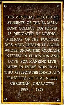
In September 1894 Meta Chestnutt, a teacher from North Carolina determined to bring education to the frontier (specifically Indians), along with the services of J.H. Bond, established the El Meta Bond College, one of the first of its kind in the area. The college offered elementary, grammar, and high school courses along with some music and drama courses. Having faced economic troubles for the whole of its existence it was eventually decommissioned in 1920 due to decreasing enrollment since the arrival of newer educational institutions that came with statehood. After the demolition of the old school building a modern masonry armory was constructed in 1936 and still stands today and serves as a community gathering center. There is also a community park occupying part of the old campus. In this park there is a plaque commemorating Meta Chestnutt and her contributions to the school.[5]
The first municipal natural gas company in Oklahoma was founded in Minco in 1960[6] by James Burton Branum, Jr.
The Minco Historical Society recently established a museum to exhibit the numerous historical facts associated with the town.
Minco currently has two weekly newspaper, The Minco Millennium. The Minco Millennium is located on the corner of Main Street and Highway 81 in Minco. The Minco Millennium has been publishing every week since the summer of 1998. The Minco-Union City Times is award winning newspaper that serves Minco and Union City.
Minco's earlier newspapers and years of publication since origin are as follows:
- Minco Minstrel 1890-1897, 190?-1916, 1921–1999
- Minco Monitor 1892-1899
- Minco Weekly 1899-1900
- Minco Herald 1916-1921 (note this time period fills in the Minstrel gap)
Microfilm copies of these papers are available at the Oklahoma Historical Society building, south of the state capital, on the second floor.
Geography
Minco is located at 35°18′56″N 97°56′45″W / 35.31556°N 97.94583°W (35.315552, -97.945698).[7]
According to the United States Census Bureau, the city has a total area of 12.3 square miles (32 km2), of which, 12.2 square miles (32 km2) of it is land and 0.08% is water.
When you enter town a sign reads: "Welcome to Minco, The Land of Milk and Honey". It is based on the town having a large number of dairy farmers and Oklahoma's largest beekeeping company, Gibson-Ross Clover Bloom Honey. Every first Saturday of December the town brings in thousands of tourists to the Christmas Honey Festival. Jim Ross, owner of the Ross Honey Company, gives tours all day and shows the entire honey production process.
A musical tour of the town by comic Lucas Ross can be seen here.[8]
Demographics
| Historical population | |||
|---|---|---|---|
| Census | Pop. | %± | |
| 1910 | 706 | — | |
| 1920 | 606 | −14.2% | |
| 1930 | 962 | 58.7% | |
| 1940 | 921 | −4.3% | |
| 1950 | 978 | 6.2% | |
| 1960 | 1,021 | 4.4% | |
| 1970 | 1,129 | 10.6% | |
| 1980 | 1,489 | 31.9% | |
| 1990 | 1,411 | −5.2% | |
| 2000 | 1,672 | 18.5% | |
| 2010 | 1,632 | −2.4% | |
| Est. 2015 | 1,656 | [9] | 1.5% |
As of the census[1] of 2000, there were 1,672 people, 658 households, and 467 families residing in the city. The population density was 136.5 people per square mile (52.7/km²). There were 714 housing units at an average density of 58.3 per square mile (22.5/km²). The racial makeup of the city was 91.99% White, 0.06% African American, 3.11% Native American, 0.06% Asian, 2.33% from other races, and 2.45% from two or more races. Hispanic or Latino of any race were 3.47% of the population.
There were 658 households out of which 36.3% had children under the age of 18 living with them, 59.7% were married couples living together, 7.6% had a female householder with no husband present, and 28.9% were non-families. 27.1% of all households were made up of individuals and 16.4% had someone living alone who was 65 years of age or older. The average household size was 2.54 and the average family size was 3.07.
In the city the population was spread out with 29.1% under the age of 18, 7.8% from 18 to 24, 26.8% from 25 to 44, 20.7% from 45 to 64, and 15.7% who were 65 years of age or older. The median age was 36 years. For every 100 females there were 93.3 males. For every 100 females age 18 and over, there were 92.5 males.
The median income for a household in the city was $31,098, and the median income for a family was $40,223. Males had a median income of $30,357 versus $22,426 for females. The per capita income for the city was $18,331. About 9.7% of families and 13.5% of the population were below the poverty line, including 13.2% of those under age 18 and 22.3% of those age 65 or over.
Phillip Nelson Richardson, former state representative
- Sherri Hill, fashion designer
References
- 1 2 "American FactFinder". United States Census Bureau. Retrieved 2008-01-31.
- ↑ "US Board on Geographic Names". United States Geological Survey. 2007-10-25. Retrieved 2008-01-31.
- ↑ "Minco Community Page". Retrieved 2008-12-14.
- 1 2 3 4 5 GG Williams (1969). "Do You Remember When?". Retrieved 2008-12-14.
- ↑ Ralph Marsh (June 3, 1958). "'Chickasha Daily Express'". Retrieved 2008-12-14.
- ↑
- ↑ "US Gazetteer files: 2010, 2000, and 1990". United States Census Bureau. 2011-02-12. Retrieved 2011-04-23.
- ↑ https://www.youtube.com/watch?v=wQAuyx98oME
- ↑ "Annual Estimates of the Resident Population for Incorporated Places: April 1, 2010 to July 1, 2015". Retrieved July 2, 2016.
- ↑ "Census of Population and Housing". Census.gov. Retrieved June 4, 2015.
