Malkowice, Świętokrzyskie Voivodeship
| Malkowice | |
|---|---|
| Village | |
 Malkowice | |
| Coordinates: 50°40′33″N 21°11′35″E / 50.67583°N 21.19306°E | |
| Country |
|
| Voivodeship | Świętokrzyskie |
| County | Staszów |
| Gmina | Bogoria |
| Sołectwo | Malkowice |
| Elevation | 279.9 m (918.3 ft) |
| Population (31 December 2009 at Census)[1] | |
| • Total |
|
| Time zone | CET (UTC+1) |
| • Summer (DST) | CEST (UTC+2) |
| Postal code | 28-210 |
| Area code(s) | +48 15 |
| Car plates | TSZ |
Malkowice[2][3] [malkɔˈvit͡sɛ] (till December 31, 2000 the official name of locality did not exist in Polish law[2][3]) is a village in the administrative district of Gmina Bogoria, within Staszów County, Świętokrzyskie Voivodeship, in south-central Poland. It lies approximately 5 kilometres (3 mi) north-west of Bogoria, 13 km (8 mi) north of Staszów, and 48 km (30 mi) south-east of the regional capital Kielce.[4]
The village has a population of ![]() 144.
144.
Demography
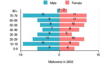
According to the 2002 Poland census, there were 156 people residing in Malkowice village, of whom 53.8% were male and 46.2% were female. In the village, the population was spread out with 19.9% under the age of 18, 32.7% from 18 to 44, 17.9% from 45 to 64, and 29.5% who were 65 years of age or older.[1]
Table 1. Population level of village in 2002 — by age group[1] SPECIFICATION Measure
unitPOPULATION
(by age group in 2002)TOTAL 0-9 10-19 20-29 30-39 40-49 50-59 60-69 70-79 80 + I. TOTAL person 156 15 23 21 14 15 18 20 26 4 — of which in % 100 9.6 14.7 13.5 9 9.6 11.5 12.8 16.7 2.6 1. BY SEX A. Males person 84 9 15 11 9 7 8 9 15 1 — of which in % 53.8 5.8 9.6 7.1 5.8 4.5 5.1 5.8 9.6 0.6 B. Females person 72 6 8 10 5 8 10 11 11 3 — of which in % 46.2 3.8 5.1 6.4 3.2 5.1 6.4 7.1 7.1 1.9
Figure 1. Population pyramid of village in 2002 — by age group and sex[1]
Table 2. Population level of village in 2002 — by sex[1] SPECIFICATION Measure
unitPOPULATION
(by sex in 2002)TOTAL Males Females I. TOTAL person 156 84 72 — of which in % 100 53.8 46.2 1. BY AGE GROUP A. At pre-working age person 31 20 11 — of which in % 19.9 12.8 7.1 B. At working age. grand total person 79 43 36 — of which in % 50.6 27.5 23.1 a. at mobile working age person 51 28 23 — of which in % 32.7 17.9 14.8 b. at non-mobile working age person 28 15 13 — of which in % 17.9 9.6 8.3 C. At post-working age person 46 21 25 — of which in % 29.5 13.5 16
References
- 1 2 3 4 5 "Local Data Bank (Bank Danych Lokalnych) – Layout by NTS nomenclature (Układ wg klasyfikacji NTS)". demografia.stat.gov.pl: GUS. 10 March 2011.
- 1 2 Biernacki, Marek (27 November 2000). "Dz.U. z 2000 r. nr 109, poz. 1163" [Journal of the Laws of 2000, No. 109, item 1,163]. Rozporządzenie Ministra Spraw Wewnętrznych i Administracji z dnia 27 listopada 2000 r. w sprawie ustalenia i zmiany urzędowych nazw oraz rodzaju niektórych miejscowości w województwach: dolnośląskim, kujawsko-pomorskim, lubelskim, lubuskim, łódzkim, mazowieckim, podkarpackim, podlaskim, pomorskim, śląskim, świętokrzyskim, warmińsko-mazurskim, wielkopolskim i zachodniopomorskim [Regulation of the Minister of the Internal Affairs and Administration of November 27, 2000 on the establishment and change the official names of localities and the type of settlement in the provinces: Lower Silesia, Kuyavia-Pomerania, Lublin, Lubusz, Łódź, Subcarpathia, Podlaskie, Pomerania, Silesia, Świętokrzyskie, Warmia-Masuria, Greater Poland and West Pomerania] (in Polish). Warsaw, Poland: Ministry of Internal Affairs and Administration. p. 6,202.
- 1 2 "Malkowice, wieś, gmina Bogoria, powiat staszowski, województwo świętokrzyskie" [Malkowice, village, Bogoria Commune, Staszów County, Świętokrzyskie Province, Poland]. Topographical map prepared in 1:10,000 scale. Aerial and satellite orthophotomap (in Polish). Head Office of Geodesy and Cartography, Poland, Warsaw. 2011. geoportal.gov.pl. Retrieved 27 April 2011.
- ↑ "Central Statistical Office (GUS) - TERYT (National Register of Territorial Land Apportionment Journal)" (in Polish). 2008-06-01.
| Seat |  | |
|---|---|---|
| Other villages |
| |
| Parts of village |
| |
| Colony of village |
| |
| Hamlets of village |
| |
| Colonies |
| |
| Hamlet |
| |
Coordinates: 50°40′22″N 21°11′55″E / 50.67278°N 21.19861°E