List of listed buildings in Dunrossness
This is a list of listed buildings in the parish of Dunrossness in the Shetland Islands, Scotland.
List
| Name | Location | Date Listed | Grid Ref. [note 1] | Geo-coordinates | Notes | HB Number [note 2] | Image |
|---|---|---|---|---|---|---|---|
| Fair Isle, Aerogenerator | 59°31′17″N 1°38′28″W / 59.521271°N 1.64104°W | Category B | 44538 | 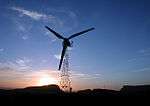
| |||
| Mail Kirk And Manse | 60°02′04″N 1°13′50″W / 60.034317°N 1.230613°W | Category C(S) | 44544 | 
| |||
| Bremire Crofthouse, Including Barns, Byre, Kiln, And Yard Wall | 59°56′16″N 1°18′25″W / 59.937862°N 1.30704°W | Category C(S) | 5415 |
| |||
| Fair Isle, Fair Isle Old Hall (Now Museum) | 59°31′03″N 1°38′34″W / 59.51754°N 1.642847°W | Category B | 5418 |
| |||
| Troswick Clack Mills, Including Road Bridge And Footbridges | 59°56′14″N 1°16′28″W / 59.937264°N 1.274448°W | Category B | 5440 |
| |||
| Sumburgh Head, Sumburgh Lighthouse, Including Ancillary Buildings, Fog Horn House, Sundial, Boundary And Retaining Walls, Gates And Gatepiers | 59°51′16″N 1°16′27″W / 59.854508°N 1.274215°W | Category A | 5442 | 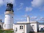
| |||
| Fair Isle, Head Of Tind, South Fair Isle Lighthouse, Including Outbuilding, Sundial, Former Toilets And Petrol Store, Fog Horn House, Boundary Walls And Gatepiers, Former Lifeboat House, Winch, And Semaphore | 59°30′50″N 1°39′08″W / 59.513947°N 1.65225°W | Category B | 5411 | 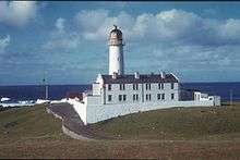
| |||
| Southvoe , Shetland Crofthouse Museum Including Byre, Barn And Kiln, Boat-Roofed Shed, Kailyard And Boundary Walls | 59°54′53″N 1°17′21″W / 59.914707°N 1.289193°W | Category B | 5413 | 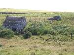
| |||
| Sandsair Pier | 60°00′25″N 1°13′14″W / 60.006808°N 1.220492°W | Category B | 49410 |
| |||
| Fair Isle, Fair Isle Methodist Chapel, Including Boundary Wall And Gatepiers | 59°31′03″N 1°38′32″W / 59.517367°N 1.642107°W | Category C(S) | 44540 | 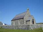
| |||
| Sumburgh House (Now Hotel), Including Terrace, Boundary Walls, And Gatepiers | 59°52′10″N 1°17′14″W / 59.869306°N 1.287269°W | Category B | 44548 | .jpg)
| |||
| Villains Crofthouse, Including Outbuildings | 60°02′15″N 1°13′54″W / 60.037385°N 1.231583°W | Category C(S) | 44549 |
| |||
| Sand Lodge, Including Walled Garden, Folly, Glasshouses, Conservatory, Steading And Cottage, Doocot, Sundial, Boundary Walls, Gates And Gatepiers | 60°00′22″N 1°13′06″W / 60.006095°N 1.218447°W | Category B | 5444 | 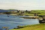
| |||
| Fair Isle, North Fair Isle Lighthouse, Including Boundary Wall, Gate And Gatepiers, Sundial, Walkway And Fog Horn House | 59°33′07″N 1°36′37″W / 59.55192°N 1.610201°W | Category B | 5446 | 
| |||
| Fair Isle, Haa Of Fair Isle, Including Garage And Boundary Walls | 59°30′58″N 1°38′34″W / 59.516175°N 1.642809°W | Category B | 5447 | 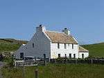
| |||
| Sumburgh Home Farm, Including Farmhouse, Steading, Kiln And Boundary Walls | 59°52′04″N 1°16′53″W / 59.867856°N 1.281514°W | Category B | 5412 |
| |||
| Fair Isle, Fair Isle Kirk (Church Of Scotland), Including Boundary Wall And Gatepiers | 59°31′17″N 1°38′12″W / 59.521393°N 1.636727°W | Category C(S) | 44539 | 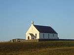
| |||
| Fair Isle, Shirva, Telephone Kiosk | 59°31′18″N 1°38′37″W / 59.521601°N 1.643723°W | Category B | 44542 |
| |||
| Southvoe, Burn Of Wiltrow, Southvoe Water Mills, Including Footbridges | 59°54′49″N 1°17′08″W / 59.913475°N 1.285482°W | Category B | 5414 |
| |||
| Brew, Dunrossness Kirk (Church Of Scotland), Including Kirkyard Wall And Gatepiers | 59°55′12″N 1°18′07″W / 59.919912°N 1.302013°W | Category B | 5439 |
| |||
| Sandwick Church (Church Of Scotland), Including Railings, Walls And Gatepiers | 59°59′48″N 1°13′33″W / 59.996702°N 1.225911°W | Category B | 78 | 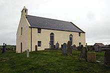
| |||
| Fair Isle, North Haven, Storehouse | 59°32′14″N 1°36′25″W / 59.537345°N 1.606868°W | Category C(S) | 44541 | 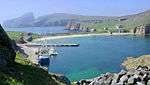
| |||
| Sandwick Manse, Including Outbuildings, Boundary And Garden Walls And Summerhouse | 59°59′58″N 1°13′51″W / 59.999317°N 1.230816°W | Category B | 5443 |
| |||
| Grutness, Lighthouse Store, Including Boundary Wall, Gate, And Gatepiers | 59°52′22″N 1°16′44″W / 59.872781°N 1.278979°W | Category C(S) | 44543 |
| |||
| Out Voe, Fish-Curing Station | 59°55′20″N 1°17′19″W / 59.922346°N 1.288564°W | Category B | 44545 |
| |||
| Quendale Haa, Including Boundary Wall, And Gateway | 59°54′06″N 1°20′18″W / 59.901665°N 1.338396°W | Category B | 44546 |
| |||
| Bigton, Bigton House, Including Walls And Gatepiers | 59°58′18″N 1°19′32″W / 59.971755°N 1.325446°W | Category B | 5416 |
| |||
| Quendale Mill, Including Dam, Steading, Walls, And Bridge | 59°54′09″N 1°20′19″W / 59.902402°N 1.338525°W | Category A | 5417 | 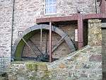
| |||
| Bigton, St Ninian's Church (Church Of Scotland), Including Boundary Wall And Gatepiers | 59°58′29″N 1°18′47″W / 59.974853°N 1.313183°W | Category C(S) | 44537 |
|
Key
The scheme for classifying buildings in Scotland is:
- Category A: "buildings of national or international importance, either architectural or historic, or fine little-altered examples of some particular period, style or building type."[1]
- Category B: "buildings of regional or more than local importance, or major examples of some particular period, style or building type which may have been altered."[1]
- Category C(S): "buildings of local importance, lesser examples of any period, style, or building type, as originally constructed or moderately altered; and simple traditional buildings which group well with others in categories A and B."[1]
There are approximately 47,400 listed buildings in Scotland. Of these, around 8 per cent (some 3,800) are Category A, and 51 per cent (24,000) are Category B, with the rest listed at Category C(s).[2]
Notes
- ↑ Sometimes known as OSGB36, the grid reference (where provided) is based on the British national grid reference system used by the Ordnance Survey.
• "Guide to National Grid". Ordnance Survey. Retrieved 2007-12-12.
• "Get-a-map". Ordnance Survey. Retrieved 2007-12-17. - ↑ The "HB Number" is a unique number assigned to each listed building by Historic Scotland.
References
- All entries, addresses and coordinates are based on data from Historic Scotland. This data falls under the Open Government Licence
- 1 2 3 "What is Listing?". Historic Scotland. Retrieved 2010-07-06.
- ↑ Guide to the Protection of Scotland’s Listed Buildings (PDF). Historic Scotland. 2009. p. 17. ISBN 978-1-84917-013-0. Retrieved 2010-07-06.
This article is issued from Wikipedia - version of the 10/15/2016. The text is available under the Creative Commons Attribution/Share Alike but additional terms may apply for the media files.