La Cochette
| La Cochette | |
|---|---|
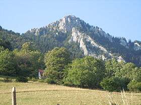 The view from the hamlet les Cruz (Corbel). | |
| Highest point | |
| Elevation | 1,618 m (5,308 ft) |
| Coordinates | 45°27′19″N 05°20′08″E / 45.45528°N 5.33556°ECoordinates: 45°27′19″N 05°20′08″E / 45.45528°N 5.33556°E |
| Geography | |
 La Cochette France | |
| Location | Savoie, France |
| Parent range | Chartreuse Mountains |
| Climbing | |
| Easiest route | From the Col du Grapillon |
La Cochette is a mountain of the Chartreuse Mountains culminating at 1618 m above sea level[1] and located at the edge of Corbel, of Saint-Jean-de-Couz and of Entremont-le-Vieux in Savoie .
References
- ↑ "La Cochette – from Le Désert d'Entremont". grenoble-montagne.com. Retrieved February 26, 2016.
This article is issued from Wikipedia - version of the 2/26/2016. The text is available under the Creative Commons Attribution/Share Alike but additional terms may apply for the media files.