Guayaques
| Guayaques volcanic group | |
|---|---|
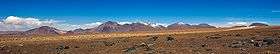 The Guayaques volcanic group seen from RN 27. | |
| Highest point | |
| Elevation | 5,076 m (16,654 ft) |
| Coordinates | 22°55.731′S 67°34.851′W / 22.928850°S 67.580850°WCoordinates: 22°55.731′S 67°34.851′W / 22.928850°S 67.580850°W |
| Geography | |
| Location | Bolivia-Chile |
| Parent range | Andes |
| Geology | |
| Mountain type | Lava domes |
| Last eruption | Unknown |
The 10-km-long Guayaques chain of N-S-trending rhyodacitic lava domes runs across the Chile-Bolivia border about 10 km. east of the Cerro Toco - Purico Complex.
See also
External links
This article is issued from Wikipedia - version of the 5/21/2014. The text is available under the Creative Commons Attribution/Share Alike but additional terms may apply for the media files.