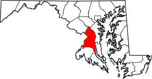
Good Luck, Maryland
| Good Luck, Maryland | |
|---|---|
| Ghost town and former census-designated place | |
 Good Luck, Maryland  Good Luck, Maryland | |
| Coordinates: 38°59′36″N 76°49′57″W / 38.99333°N 76.83250°WCoordinates: 38°59′36″N 76°49′57″W / 38.99333°N 76.83250°W | |
| Country | United States of America |
| State | Maryland |
| County | Prince George's |
| Elevation | 171 ft (52 m) |
| Time zone | Eastern (EST) (UTC-5) |
| • Summer (DST) | EDT (UTC-4) |
| GNIS feature ID | 1714391[1] |
Good Luck is a ghost town and former census-designated place in Prince George's County, Maryland, United States.[1]
Established in 1672, the former settlement is currently occupied by the Goddard Space Flight Center and a residential community.
History
Good Luck was a 100-acre (40 ha) property deeded to Alexander Magruder in 1672.[2] Magruder owned approximately 4,000-acre (1,600 ha) of land in Maryland, and some of his properties, such as Good Luck, were named after locations in the Scottish Highlands.[3]
The size of the property had grown to 500 acres (200 ha) by 1677.[2]
In 1702, 780 acres (320 ha) of land known as "Good Luck" was sold.[4]
A post office was established in 1817 called "Magruder's". The post office was renamed "Good Luck" and operated from 1830 to 1852, and from 1872 to 1876.[5]
Decline
In 1871, the village of Glennville (later renamed Glenn Dale) was platted by John Glenn and Edmund B. Duvall. Located on the Baltimore and Potomac Railroad, Glenn Dale prospered, and in 1876, Good Luck's post office was moved there.[5][6][7] In 1899, Good Luck was described as a "rural village" alongside "the railroad village of Glenn Dale".[6]
"Good Luck Road" is still located at the site of the former settlement, which is currently occupied by the Goddard Space Flight Center and a residential community.[8]
Census designated place
A census-designated place (CDP) called "Good Luck" was established in the general area of the former settlement during the 1970 United States Census. The population of the Good Luck CDP was 10,584.[9] The land area of the CDP was 3.2 sq mi (8.3 km2) and a population density was 3,308 per square mile.[10] In 1980, Good Luck CDP ceased to exist after the census area was split to create the CDPs of Glenn Dale and Goddard.[11]
References
- 1 2 U.S. Geological Survey Geographic Names Information System: Good Luck (historical)
- 1 2 "Alexander Magruder". Early Colonial Settlers of Southern Maryland and Virginia's Northern Neck Counties. Retrieved November 30, 2016.
- ↑ Magruder, Edward May (1923). Magruder, Egbert Watson, ed. Annual Address (PDF). Year Book of American Clan Gregor Society. Indian Press. pp. 20, 21.
- ↑ Doliante, Sharon J. (1991). Maryland and Virginia Colonials. Genealogical Publishing. p. 53.
- 1 2 Skarda, Don D. (March 1989). "Prince George's County Postal Service" (PDF). News and Notes from The Prince George's County Historical Society. The Prince George's County Historical Society. XVII (3).
- 1 2 "Maryland Inventory of Historic Properties Form" (PDF). Maryland Historical Trust. March 2009.
- ↑ Industries of Maryland: A Descriptive Review of the Manufacturing and Mercantile Industries of the City of Baltimore. Historical Publishing Company. 1882. p. 77.
- ↑ "News and Notes" (PDF). News and Notes from the Prince George's County Historical Society. Prince George's County Historical Society. IX (4). April 1981.
- ↑ 1970 Census of Population: Characteristics of the Population: Maryland (PDF). U.S. Department of Commerce. February 1973. p. 11.
- ↑ 1970 Census of Population. Characteristics of the Population: United States Summary. U.S. Government Printing Office. 1973. p. 140.
- ↑ 1980 Census of Population: Population and Land Area of Urbanized Areas for the United States and Puerto Rico, 1980 and 1970 - Supplementary Report. U.S. Department of Commerce. 1984. p. 99.
