Foristell, Missouri
| Foristell, Missouri | |
|---|---|
| City | |
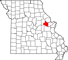
 Location of Foristell, Missouri | |
| Coordinates: 38°49′3″N 90°57′24″W / 38.81750°N 90.95667°WCoordinates: 38°49′3″N 90°57′24″W / 38.81750°N 90.95667°W | |
| Country | United States |
| State | Missouri |
| Counties | St. Charles, Warren |
| Area[1] | |
| • Total | 5.62 sq mi (14.56 km2) |
| • Land | 5.53 sq mi (14.32 km2) |
| • Water | 0.09 sq mi (0.23 km2) |
| Elevation | 709 ft (216 m) |
| Population (2010)[2] | |
| • Total | 505 |
| • Estimate (2012[3]) | 505 |
| • Density | 91.3/sq mi (35.3/km2) |
| Time zone | Central (CST) (UTC-6) |
| • Summer (DST) | CDT (UTC-5) |
| FIPS code | 29-25120[4] |
| GNIS feature ID | 0756069[5] |
Foristell is a city in St. Charles and Warren counties in the U.S. state of Missouri. The population was 505 at the 2010 census.
Geography
Foristell is located at 38°49′3″N 90°57′24″W / 38.81750°N 90.95667°W (38.817542, -90.956737).[6]
According to the United States Census Bureau, the city has a total area of 5.62 square miles (14.56 km2), of which, 5.53 square miles (14.32 km2) is land and 0.09 square miles (0.23 km2) is water.[1]
Demographics
| Historical population | |||
|---|---|---|---|
| Census | Pop. | %± | |
| 1980 | 119 | — | |
| 1990 | 144 | 21.0% | |
| 2000 | 331 | 129.9% | |
| 2010 | 505 | 52.6% | |
| Est. 2015 | 520 | [7] | 3.0% |
As of 2000 the median income for a household in the city was $52,386, and the median income for a family was $53,750. Males had a median income of $43,750 versus $33,333 for females. The per capita income for the city was $22,331. About 7.1% of families and 8.9% of the population were below the poverty line, including 16.3% of those under age 18 and 4.4% of those age 65 or over.
2010 census
As of the census[2] of 2010, there were 505 people, 192 households, and 151 families residing in the city. The population density was 91.3 inhabitants per square mile (35.3/km2). There were 208 housing units at an average density of 37.6 per square mile (14.5/km2). The racial makeup of the city was 93.3% White, 3.6% African American, 0.2% Native American, 0.2% Asian, 0.8% from other races, and 2.0% from two or more races. Hispanic or Latino of any race were 0.8% of the population.
There were 192 households of which 31.8% had children under the age of 18 living with them, 69.3% were married couples living together, 5.7% had a female householder with no husband present, 3.6% had a male householder with no wife present, and 21.4% were non-families. 18.2% of all households were made up of individuals and 4.7% had someone living alone who was 65 years of age or older. The average household size was 2.63 and the average family size was 2.98.
The median age in the city was 44.8 years. 23% of residents were under the age of 18; 6.9% were between the ages of 18 and 24; 20.5% were from 25 to 44; 35.2% were from 45 to 64; and 14.3% were 65 years of age or older. The gender makeup of the city was 51.5% male and 48.5% female.
History
The city now known as Foristell started in 1856 under the name of "Millville". The first homes, as well as a railroad, were constructed in that year. In 1858, Millville built its first post office.[9]
The community saw rapid growth during the American Civil War. A mill and a tobacco factory were both established. It was during this time that a man by the name of Pierre Foristell gained respect throughout the community. The town of Millville officially changed its name to Foristell in 1875.[10]
In 1979 Foristell was incorporated into a village. Just nine years later, however, the residents voted to make it a fourth-class city. This transition occurred the following year, in 1989.
City Hall / Police Department
The Foristell City Hall is located at #121 Mulberry Street, Foristell, MO 63348. The Foristell Police Department is located at #30 First Street, Foristell, MO 63348. Foristell PD has 8 full-time officers and 6-7 Patrol cars in their fleet consisting of 5-6 Ford Police Interceptors purchased used and a 2010 Dodge Charger DWI Enforcement Unit won for participating in DWI campaigns. Foristell PD is dispatched by the Wentzville Police Department. Foristell is known as a speed trap to motorists due to the large number of traffic stops made by Foristell Police officers, however, Foristell PD has made over 137 DWI arrests in 2010 alone as well as recovered 1.75 lbs of Heroin and 500 lbs of Marijuana on the drug corridor of Interstate 70 keeping drugs out of the St. Louis Area.
As of November 2009 the current officials of Foristell are:
- Mayor: Wanda Donnelly
- City Administrator/Clerk: Sandy Stokes
- Treasurer: Lori Oehler
- Chief of Police: Douglas G. Johnson DSN 701
- Supervisor of Public Works: Doyle D. Stokes
- Board of Aldermen: Carol Rose, Joseph Goatley (Ward 1) John Pickering, Leon Rogers (Ward 2)
References
- 1 2 "US Gazetteer files 2010". United States Census Bureau. Retrieved 2012-07-08.
- 1 2 "American FactFinder". United States Census Bureau. Retrieved 2012-07-08.
- ↑ "Population Estimates". United States Census Bureau. Retrieved 2013-05-30.
- ↑ "American FactFinder". United States Census Bureau. Retrieved 2008-01-31.
- ↑ "US Board on Geographic Names". United States Geological Survey. 2007-10-25. Retrieved 2008-01-31.
- ↑ "US Gazetteer files: 2010, 2000, and 1990". United States Census Bureau. 2011-02-12. Retrieved 2011-04-23.
- ↑ "Annual Estimates of the Resident Population for Incorporated Places: April 1, 2010 to July 1, 2015". Retrieved July 2, 2016.
- ↑ "Census of Population and Housing". Census.gov. Retrieved June 4, 2015.
- ↑ http://www.cityofforistell.org/citys_history.html
- ↑ http://www.cityofforistell.org/citys_history.html

