Crostwick
| Crostwick | |
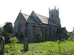
 St Peter's Church, Crostwick |
|
 Crostwick |
|
| Area | 2.82 km2 (1.09 sq mi) |
|---|---|
| OS grid reference | TG257162 |
| Civil parish | Crostwick |
| District | Broadland |
| Shire county | Norfolk |
| Region | East |
| Country | England |
| Sovereign state | United Kingdom |
| Post town | NORWICH |
| Postcode district | NR12 |
| Police | Norfolk |
| Fire | Norfolk |
| Ambulance | East of England |
| EU Parliament | East of England |
Coordinates: 52°41′50″N 1°20′24″E / 52.69724°N 1.34011°E
Crostwick is a village and civil parish in the district of Broadland, Norfolk, England. At the 2011 Census the population remained less than 100 and was included in the Civil Parish of Horstead with Stanninghall.
Notes
External links
![]() Media related to Crostwick at Wikimedia Commons
Media related to Crostwick at Wikimedia Commons
This article is issued from Wikipedia - version of the 8/2/2016. The text is available under the Creative Commons Attribution/Share Alike but additional terms may apply for the media files.