Codognè
| Codognè | |
|---|---|
| Comune | |
| Comune di Codognè[1] | |
|
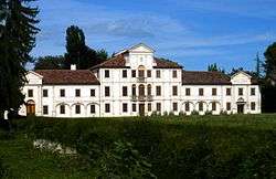
Villa Toderini | |
 Codognè Location of Codognè in Italy | |
| Coordinates: 45°52′N 12°26′E / 45.867°N 12.433°ECoordinates: 45°52′N 12°26′E / 45.867°N 12.433°E | |
| Country | Italy |
| Region | Veneto |
| Province / Metropolitan city | Treviso (TV) |
| Area | |
| • Total | 21.7 km2 (8.4 sq mi) |
| Population (Dec. 2004)[2] | |
| • Total | 5,243 |
| • Density | 240/km2 (630/sq mi) |
| Demonym(s) | Codognesi |
| Time zone | CET (UTC+1) |
| • Summer (DST) | CEST (UTC+2) |
| Postal code | 31013 |
| Dialing code | 0438 |
| Patron saint | St. Andrew the Apostle |
| Saint day | November 30 |
Codognè[3] (also spelled on dictionaries as Codogné[4] (Italian pronunciation: [kodoɲˈɲe])) is a comune (municipality) in the Province of Treviso in the Italian region Veneto, located about 50 kilometres (31 mi) north of Venice and about 25 kilometres (16 mi) northeast of Treviso.
Codognè borders the following municipalities: Fontanelle, Gaiarine, Godega di Sant'Urbano, Mareno di Piave, San Fior, San Vendemiano and Vazzola.
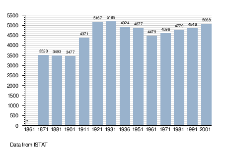
Demographic evolution

References
- ↑ Statuto del Comune di Codognè
- ↑ All demographics and other statistics: Italian statistical institute Istat.
- ↑ ISTAT (Italian National Institute of Statistics) List of statistical codes and official names of territorial units
- ↑ DOP Online
This article is issued from Wikipedia - version of the 2/26/2016. The text is available under the Creative Commons Attribution/Share Alike but additional terms may apply for the media files.
