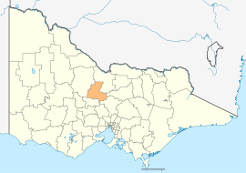
City of Greater Bendigo
| City of Greater Bendigo Victoria | |||||||||||||
|---|---|---|---|---|---|---|---|---|---|---|---|---|---|
 Location in Victoria | |||||||||||||
| Population | 108,437 (2015 est)[1] | ||||||||||||
| • Density | 35.576/km2 (92.143/sq mi) | ||||||||||||
| Established | 1994 | ||||||||||||
| Gazetted | 7 April 1994[2] | ||||||||||||
| Area | 3,048 km2 (1,176.8 sq mi) | ||||||||||||
| Mayor | Rod Fyffe | ||||||||||||
| Council seat | Bendigo | ||||||||||||
| Region | Northern Victoria | ||||||||||||
| State electorate(s) | |||||||||||||
| Federal Division(s) | |||||||||||||
 | |||||||||||||
| Website | City of Greater Bendigo | ||||||||||||
| |||||||||||||
The City of Greater Bendigo is a local government area in Victoria, Australia, located in the central part of the state. It covers an area of 3,048 square kilometres (1,177 sq mi) and, at the 2011 Census, had a population of 100,617.[3] It includes the city of Bendigo and the towns of Axedale, Elmore, Heathcote, Marong, Raywood and Strathfieldsaye. It was formed in 1994 from the amalgamation of the former City of Bendigo with the Borough of Eaglehawk, Shire of Strathfieldsaye, Shire of Huntly, Rural City of Marong and parts of the Shire of McIvor.[2]
The city is governed and administered by the Greater Bendigo City Council; its seat of local government and administrative centre is located at the council headquarters in Bendigo, it also has service centres located in Heathcote, Huntly, Marong and a couple of other locations within Bendigo. The city is named after the main urban settlement lying in the centre-west of the LGA, that is Bendigo, which is also the LGA's most populous urban centre with a population of 82,794.[4]
Council
Current composition
The council is composed of three wards and nine councillors, with three councillors per ward elected to represent each ward.[5] The most recent election was held in October 2012. The current council, elected in 2012, in order of election by ward, is:[6]
| Ward | Party | Notes | ||
|---|---|---|---|---|
| Eppalock | Independent | Rod Campbell | ||
| Independent | Mark Weragoda | |||
| Independent | Helen Leach | |||
| Lockwood | Independent | Rod Fyffe | Mayor (2015–present) | |
| One Nation[7] | Elise Chapman | |||
| Independent | Barry Lyons | |||
| Whipstick | Independent | Peter Cox | ||
| Independent | Lisa Ruffell | |||
| Independent | James Williams | |||
Administration and governance
The council meets in the council chambers at the council headquarters in the Bendigo Town Hall Offices, which is also the location of the council's administrative activities. It also provides customer services at its administrative centre on Lyttleton Terrace in Bendigo and its service centres in Heathcote, Huntly and Marong and also on Hopetoun Street and St Andrews Avenue in Bendigo.
The Bendigo Town Hall was built in stages starting in 1859 and an extension was built between 1883 and 1885.
See also
References
- ↑ "3218.0 – Regional Population Growth, Australia, 2014–15". Australian Bureau of Statistics. Retrieved 29 September 2016.
- 1 2 Victoria Government Gazette – Online Archive (1837–1997). "S12 of 1994". State Library of Victoria. State Government of Victoria (published 7 April 1994). pp. 1–5. Retrieved 10 January 2014.
|article=ignored (help) - ↑ Census QuickStats (2011). "Greater Bendigo (C) – LGA22620". Australian Bureau of Statistics. Government of Australia. Retrieved 10 January 2014.
- ↑ Census QuickStats (2011). "Bendigo (UCL) – UCL211003". Australian Bureau of Statistics. Government of Australia. Retrieved 10 January 2014.
- ↑ Local Government in Victoria. "Greater Bendigo City Council". Department of Transport, Planning and Local Infrastructure. State Government of Victoria. Retrieved 10 January 2014.
- ↑ VEC. "Results for Greater Bendigo City Council Elections 2012". Victorian Electoral Commission. Victorian Electoral Commission. Retrieved 31 October 2012.
- ↑ "Elise Chapman - VIC Senate | Pauline Hanson's One Nation". www.onenation.com.au. Retrieved 2016-01-11.
External links
- Greater Bendigo City Council official website
- Bendigo information and community site
- Metlink local public transport profile
- Link to Land Victoria interactive maps
Coordinates: 36°45′S 144°17′E / 36.750°S 144.283°E