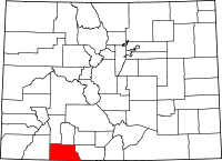
Chromo, Colorado
| Chromo, Colorado | |
|---|---|
| Unincorporated community | |
 Chromo, Colorado Location within the state of Colorado | |
| Coordinates: 37°02′13″N 106°50′36″W / 37.03694°N 106.84333°WCoordinates: 37°02′13″N 106°50′36″W / 37.03694°N 106.84333°W | |
| Country |
|
| State |
|
| County | Archuleta County[1] |
| Elevation[1] | 7,283 ft (2,220 m) |
| Time zone | MST (UTC-7) |
| • Summer (DST) | MDT (UTC-6) |
| ZIP Code | 81128[2] |
Chromo is an unincorporated community and U.S. Post Office in Archuleta County, Colorado, United States. The Chromo Post Office has the ZIP Code 81128.[2]
A post office called Chromo has been in operation since 1885.[3] The community takes its name from nearby Chromo Mountain.[4]
Geography
Chromo is located at 37°02′13″N 106°50′36″W / 37.03694°N 106.84333°W (37.036818,-106.843243).
Climate
This climatic region is typified by large seasonal temperature differences, with warm to hot (and often humid) summers and cold (sometimes severely cold) winters. According to the Köppen Climate Classification system, Chromo has a humid continental climate, abbreviated "Dfb" on climate maps.[5]
See also
References
- 1 2 "US Board on Geographic Names". United States Geological Survey. 2007-10-25. Retrieved 2008-01-31.
- 1 2 "ZIP Code Lookup". United States Postal Service. December 15, 2006. Archived from the original (JavaScript/HTML) on September 3, 2007. Retrieved December 15, 2006.
- ↑ "Post offices". Jim Forte Postal History. Archived from the original on 6 March 2016. Retrieved 24 June 2016.
- ↑ Dawson, John Frank (1954). Place names in Colorado: why 700 communities were so named, 150 of Spanish or Indian origin. Denver, CO: The J. Frank Dawson Publishing Co. p. 13.
- ↑ Climate Summary for Chromo, Colorado
External links
| Wikimedia Commons has media related to Chromo, Colorado. |
This article is issued from Wikipedia - version of the 11/24/2016. The text is available under the Creative Commons Attribution/Share Alike but additional terms may apply for the media files.

