Cardiff Central bus station
Cardiff Central bus station | |
|---|---|
|
| |
| Location |
Cardiff City Centre Cardiff |
| Operated by | Cardiff Council |
| Bus stands | 34 |
| Bus operators | |
| Connections | Cardiff Central railway station (adjacent) |
| History | |
| Opened | 1954 |
| Closed | August 2, 2015 |
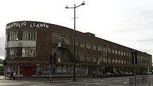
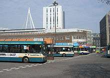
Cardiff Central bus station was the main bus transport interchange in Cardiff, the capital city of Wales. With 34 stands, it was the largest bus station in the city and in Wales. It was located adjacent to Cardiff Central railway station forming a major bus-rail-cycle-taxi interchange.
The station used to handle the vast majority of bus and coach services that run in and through the city. Notable exceptions to this are the Megabus service (which called at Kingsway and Cardiff University),[1] Stagecoach route 122 (which calls at Greyfriars Road)[2] and EST route 89 (which uses Customhouse Street).[3]
History
The site of Cardiff's bus station had previously been an area of housing and shops known as Temperance Town. However, demolition of Temperance Town commenced in 1937 after the Great Western Railway persuaded the Cardiff Corporation to improve the view from their new railway station.[4]

The Central bus station was opened in 1954.[5]

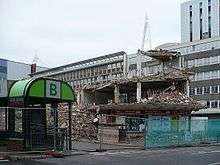
Demolition and reconstruction of the bus station began in 2008 with the terminus building being demolished. Before work began, there were 8 concourses lettered A-F and W with each concourse having numbered stands.
Redevelopment

Redevelopment of the bus station began in 2008.[6] Demolition of the old terminal buildings (between stand A and Wood Street stands) started on 11 January 2008, with buses instead picking up at Castle Street and Westgate Street. On 6 May 2008, Stand A at the bus station closed for demolition of the terminal buildings.[7] As of 4 January 2009, some services reverted to using the bus station, whilst others remained split between the alternative terminal points.[8]
A multi-million-pound modernisation of Cardiff central bus station was announced in December 2010, with three options for public consultation.[9] In December 2011 the Council announced that the existing bus station would close in early 2013 and the new bus station would be built on the site of the neighbouring Wood Street NCP Car Park. The new bus station would open in Summer 2014, and provide 19 bays and have direct access to Westgate Street and St. Mary Street via Saunders Road.[10] A further announcement was made in January 2012, that negotiations were underway to sell off the existing bus station land to two major companies, who would build a 12-storey headquarters on the site. Part of the proceeds from the sale would be put towards redesign and redevelopment of Central Square, which would be renamed 'Capital Square'.[11] These plans were put into doubt in May 2012 with the election of a new Labour-led council.[12]
In October 2014 a new masterplan was revealed for the area, produced by architects Foster and Partners. BBC Wales had earmarked the bus station as the site for their new headquarters. Proposals for a replacement bus station were to be put to Cardiff Council later in 2014.[13] In June 2015 Foster and Partners were chosen as the preferred architects and images were revealed of the new bus station, which would be completed by mid-2018. The new bus station would have 11-storeys above the ground floor bus terminus and be linked to the railway station by a glass canopy.[14]
Facilities
Eating and drinking facilities such as a Burger King, as well as other shops and bus company offices, faced the stands on Central Square. Taxi ranks were located on both sides of the station.
Toilets and a newsagent were located at stand A which was demolished in summer 2008 as part of the redevelopment of the station. However, these services are available in the adjacent Cardiff Central railway station.
Services

There were 34 stands at the station, which were located on Central Square, off Wood Street and opposite the Millennium Stadium, in the city centre of Cardiff. The old operating schedule is:
- Cardiff Bus operates: services to Cardiff's districts and suburbs, cross-city services and services to Cardiff Bay, Barry, Llandough, Cogan, Penarth, Dinas Powys, Llantwit Major and Cardiff Airport.
- Stagecoach in South Wales provides services to Caerphilly, Blackwood, Senghenydd, Pontypool, Merthyr Tydfil, Cwmbran, Abergavenny and Hereford
- Newport Bus provides two services to Newport bus station, one an 'express' route direct via the M4 and one service to Risca
- EST Buses provide services to the Vale of Glamorgan
- Arriva provides services to North and West Wales.
- First Cymru provides services to Swansea, Porthcawl, Cowbridge and Bridgend
- National Express Group provides services to Swansea, Bristol, London, Birmingham and The North and also operates services to London Heathrow Airport and London Gatwick Airport
- Eurolines began a new service to Cork, Ireland in October 2011,[15] via the Pembroke to Rosslare ferry.
See also
References
- ↑ "Archived copy". Archived from the original on 6 November 2008. Retrieved 2008-12-13.
- ↑ http://www.stagecoachbus.com/timetables/122Oct08[][2].pdf
- ↑ Archived 8 February 2015 at the Wayback Machine.
- ↑ Abandoned Communities website Abandoned Communities ..... Temperance Town (viewed 11 October 2011)
- ↑ "A short history of cardiff". www.localhistories.org. Retrieved 2008-012-13. Check date values in:
|access-date=(help) - ↑ Madeleine Brindley. "WalesOnline - News - Wales News - Relief as bus one-way plan goes on hold". Icwales.icnetwork.co.uk. Retrieved 25 February 2011.
- ↑ "home". cardiff bus. 6 May 2008. Archived from the original on 2 May 2009. Retrieved 25 February 2011.
- ↑ "Archived copy". Archived from the original on 9 June 2011. Retrieved 2009-04-15.
- ↑ Alford, Abby (3 December 2010). "Revamp for bus station coming at last - Cardiff news - CardiffOnline". WalesOnline. Retrieved 25 February 2011.
- ↑ Law, Peter (6 December 2011). "New bus station for Cardiff to open in 2014 at heart of new financial services district". Western Mail (Walesonline). Retrieved 10 December 2011.
- ↑ Law, Peter (30 January 2012). "'Exciting Times' for Capital". South Wales Echo. pp. 4–5.
- ↑ Law, Peter (22 May 2012). "'Back to the drawing board' for Cardiff's Central Business District". South Wales Echo. Retrieved 22 May 2012.
- ↑ Sion Barry (30 October 2014). "Cardiff's new Central Square development: An exclusive glimpse at the dramatic overhaul planned for the heart of the capital". Western Mail. pp. 4–5.
- ↑ Ruth Mosalski (26 June 2015). "First images of Cardiff's new bus station... it's designed by Norman Foster's firm and opens in summer 2018". Wales Online. Retrieved 28 June 2015.
- ↑ Miller, Claire "Irish coach service to honour city's lost 'Little Ireland' community with plaque" South Wales Echo 6 October 2011, pp. 26-27
Coordinates: 51°28′35″N 3°10′45″W / 51.47643°N 3.17905°W
