Brant Lake, New York
| Brant Lake | |
|---|---|
| hamlet | |
|
Brant Lake in 2003 | |
 Brant Lake | |
| Coordinates: 43°40′35″N 73°44′58″W / 43.67639°N 73.74944°WCoordinates: 43°40′35″N 73°44′58″W / 43.67639°N 73.74944°W[1] | |
| Country | United States |
| State | New York |
| County | Warren |
| Town | Horicon |
| Time zone | EST (UTC-5) |
| • Summer (DST) | DST (UTC-4) |
| ZIP code | 12815 |
| Area code | 518 |
| Website |
www |
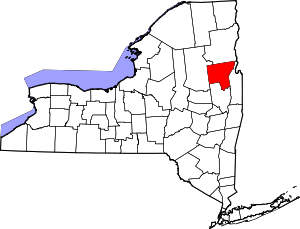
Brant Lake is a hamlet in the town of Horicon in Warren County, New York, United States.[2] It is located approximately halfway between Albany to the south and Plattsburgh to the north.
History
Since the mid-1880s, Brant Lake has been a popular fishing and hunting area among wealthy visitors including Theodore Roosevelt. Around 1900, several hotels began catering to these wealthy visitors. Summer camps for youth were established around the same time.[3] The seat of town government is today located in the hamlet.
Geography
The hamlet is just east of the Adirondack Northway, accessible via interchange 25. NY Route 8 traverses the hamlet.[4] The hamlet is named for the eponymous lake which it surrounds. Brant Lake's ZIP code is 12815. The central part of the hamlet is located to the south of the lake, but ZIP Code 12815 extends to the northern end of the lake and ultimately to the border between Warren County and Essex County. Several summer camps and vacation homes, as well as homes of those who live in the hamlet year-round, line the perimeter of the lake, especially along the eastern and northern shores. The summer camps include Brant Lake Camp, Point O' Pines Camp, Pilgrim Camp, and the Curtis S. Read Scout Reservation, the last of which is a Boy Scout camp owned by the Westchester-Putnam Council. The Read Reservation contains three sub-camps, which are Camp Buckskin, Camp Waubeeka, and Summit Base Camp, the last of which is used as a base for treks throughout the Adirondacks.
Gallery
-
The Heintzelman Library, built 1907
-
A former barbershop
References
- ↑ GNIS-enwiki
- ↑ NYS Department of Transportation Raster Quadrangle K49 (Map). 1:24,000. Cartography by USGS. NYS DOT. 1992. Retrieved April 2, 2011.
- ↑ Murtagh, Colleen. "A Brief History of Horicon". Town of Horicon Historical Society. Retrieved April 2, 2011.
- ↑ Overview of Brant Lake near I-87 (Map). Cartography by Google. Google. Retrieved April 2, 2011.
