Białka, Lesser Poland Voivodeship
For other places with the same name, see Białka.
| Białka | |
|---|---|
| Village | |
|
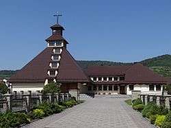
A local Catholic church | |
 Białka | |
| Coordinates: 49°41′30″N 19°40′10″E / 49.69167°N 19.66944°E | |
| Country |
|
| Voivodeship | Lesser Poland |
| County | Sucha |
| Gmina | Maków Podhalański |
| Elevation | 410 m (1,350 ft) |
| Population | 2,542 |
| Website | http://wiesbialka.pl.tl |
Białka [ˈbjau̯ka] is a village in the administrative district of Gmina Maków Podhalański, within Sucha County, Lesser Poland Voivodeship, in southern Poland.[1] It lies approximately 5 kilometres (3 mi) south of Maków Podhalański, 8 km (5 mi) south-east of Sucha Beskidzka, and 46 km (29 mi) south-west of the regional capital Kraków.
The village has a population of 2,542.
References
| Town and seat |  | |
|---|---|---|
| Villages | ||
Coordinates: 49°41′30″N 19°40′10″E / 49.69167°N 19.66944°E
This article is issued from Wikipedia - version of the 5/20/2016. The text is available under the Creative Commons Attribution/Share Alike but additional terms may apply for the media files.