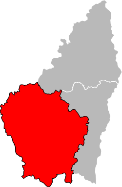
Arrondissement of Largentière
| Largentière | |
|---|---|
| Arrondissement of France | |
 Location of Largentière in Ardèche | |
| Country | France |
| Region | Auvergne-Rhône-Alpes |
| Department | Ardèche |
| Communes | 148 |
| Subprefecture | Largentière |
| Area¹ | |
| • Total | 2,511 km2 (970 sq mi) |
| Population (2013) | |
| • Total | 97,967 |
| • Density | 39/km2 (100/sq mi) |
| ¹ French Land Register data, which exclude lakes, ponds, and glaciers larger than 1 km² as well as the estuaries of rivers. | |
The arrondissement of Largentière is an arrondissement of France in the Ardèche department in the Auvergne-Rhône-Alpes region. In 2007 it was expanded with the four cantons of Antraigues-sur-Volane, Aubenas, Vals-les-Bains and Villeneuve-de-Berg from the arrondissement of Privas.[1] It has 148 communes.
Composition
Cantons
The cantons of the arrondissement of Largentière are:
- Aubenas-1
- Aubenas-2
- Le Teil (partly)
- Thueyts
- Vallon-Pont-d'Arc (partly)
- Les Vans
Communes
The communes of the arrondissement of Largentière are:[2]
- Ailhon
- Aizac
- Antraigues-sur-Volane
- Asperjoc
- Les Assions
- Astet
- Aubenas
- Balazuc
- Banne
- Barnas
- Le Béage
- Beaulieu
- Beaumont
- Berrias-et-Casteljau
- Berzème
- Bessas
- Borne
- Burzet
- Cellier-du-Luc
- Chambonas
- Chandolas
- Chassiers
- Chauzon
- Chazeaux
- Chirols
- Coucouron
- Cros-de-Géorand
- Darbres
- Dompnac
- Fabras
- Faugères
- Fons
- Genestelle
- Gravières
- Grospierres
- Issanlas
- Issarlès
- Jaujac
- Joannas
- Joyeuse
- Juvinas
- Labastide-de-Virac
- Labastide-sur-Bésorgues
- Labeaume
- Labégude
- Lablachère
- Laboule
- Le Lac-d'Issarlès
- Lachamp-Raphaël
- Lachapelle-Graillouse
- Lachapelle-sous-Aubenas
- Lagorce
- Lalevade-d'Ardèche
- Lanarce
- Lanas
- Largentière
- Laurac-en-Vivarais
- Laval-d'Aurelle
- Laveyrune
- Lavillatte
- Lavilledieu
- Laviolle
- Lentillères
- Lespéron
- Loubaresse
- Lussas
- Malarce-sur-la-Thines
- Malbosc
- Mayres
- Mazan-l'Abbaye
- Mercuer
- Meyras
- Mézilhac
- Mirabel
- Montpezat-sous-Bauzon
- Montréal
- Montselgues
- Orgnac-l'Aven
- Payzac
- Péreyres
- Le Plagnal
- Planzolles
- Pont-de-Labeaume
- Prades
- Pradons
- Prunet
- Ribes
- Rochecolombe
- Rocher
- Rocles
- Rosières
- Le Roux
- Ruoms
- Sablières
- Sagnes-et-Goudoulet
- Saint-Alban-Auriolles
- Saint-Alban-en-Montagne
- Saint-Andéol-de-Berg
- Saint-Andéol-de-Vals
- Saint-André-de-Cruzières
- Saint-André-Lachamp
- Saint-Cirgues-de-Prades
- Saint-Cirgues-en-Montagne
- Saint-Didier-sous-Aubenas
- Sainte-Eulalie
- Sainte-Marguerite-Lafigère
- Saint-Étienne-de-Boulogne
- Saint-Étienne-de-Fontbellon
- Saint-Étienne-de-Lugdarès
- Saint-Genest-de-Beauzon
- Saint-Germain
- Saint-Gineis-en-Coiron
- Saint-Jean-le-Centenier
- Saint-Joseph-des-Bancs
- Saint-Julien-du-Serre
- Saint-Laurent-les-Bains
- Saint-Laurent-sous-Coiron
- Saint-Maurice-d'Ardèche
- Saint-Maurice-d'Ibie
- Saint-Mélany
- Saint-Michel-de-Boulogne
- Saint-Paul-le-Jeune
- Saint-Pierre-de-Colombier
- Saint-Pierre-Saint-Jean
- Saint-Pons
- Saint-Privat
- Saint-Sauveur-de-Cruzières
- Saint-Sernin
- Salavas
- Les Salelles
- Sampzon
- Sanilhac
- La Souche
- Tauriers
- Thueyts
- Ucel
- Usclades-et-Rieutord
- Uzer
- Vagnas
- Valgorge
- Vallon-Pont-d'Arc
- Vals-les-Bains
- Les Vans
- Vernon
- Vesseaux
- Villeneuve-de-Berg
- Vinezac
- Vogüé
References
External links
Coordinates: 44°32′24″N 4°17′29″E / 44.54000°N 4.29139°E
This article is issued from Wikipedia - version of the 4/28/2016. The text is available under the Creative Commons Attribution/Share Alike but additional terms may apply for the media files.