Aliaga, Nueva Ecija
| Aliaga | ||
|---|---|---|
| Municipality | ||
|
Aliaga Municipal Hall | ||
| ||
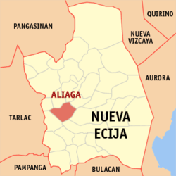
 Map of Nueva Ecija showing the location of Aliaga | ||
.svg.png) Aliaga Location within the Philippines | ||
| Coordinates: 15°30′0″N 120°50′38″E / 15.50000°N 120.84389°ECoordinates: 15°30′0″N 120°50′38″E / 15.50000°N 120.84389°E | ||
| Country | Philippines | |
| Region | Central Luzon (Region III) | |
| Province | Nueva Ecija | |
| District | 1st District | |
| Barangays | 26 | |
| Government[1] | ||
| • Mayor | Elizabeth Roman Vargas | |
| Area[2] | ||
| • Total | 90.04 km2 (34.76 sq mi) | |
| Population (2010)[3] | ||
| • Total | 57,805 | |
| • Density | 640/km2 (1,700/sq mi) | |
| Time zone | PST (UTC+8) | |
| ZIP code | 3111 | |
| Dialing code | 44 | |
| Income class | 2nd class; rural | |
Aliaga is a second class municipality in the province of Nueva Ecija, Philippines, Formerly it was called Pulung Bibit and Maynilang Munti (Little Manila). The First mayor is Aneceto Pere. According to the 2010 census, it has a population of 57,805 people.
It has a comparatively cool and healthful climate, and is pleasantly situated about midway between the Pampanga Grande and the Pampanga Chico rivers, and in a large and fertile valley of which the principal products are mostly agricultural such as rice, tomato, eggplant, squash.
Tagalog and Ilocano are the most important and the major languages of the municipality.
Barangays
Aliaga is politically subdivided into 26 barangays.
- Betes
- Bibiclat
- Bucot
- La Purisima
- Magsaysay
- Macabucod
- Pantoc
- Poblacion Centro
- Poblacion East I
- Poblacion East II
- Poblacion West III
- Poblacion West IV
- San Carlos
- San Emiliano
- San Eustacio
- San Felipe Bata
- San Felipe Matanda
- San Juan
- San Pablo Bata
- San Pablo Matanda
- Santa Monica
- Santiago
- Santo Rosario
- Santo Tomas
- Sunson
- Umangan
Demographics
| Population census of Aliaga | ||
|---|---|---|
| Year | Pop. | ±% p.a. |
| 1990 | 40,425 | — |
| 1995 | 45,815 | +2.37% |
| 2000 | 50,004 | +1.89% |
| 2007 | 61,270 | +2.84% |
| 2010 | 57,805 | −2.10% |
| Source: National Statistics Office[3] | ||
References
- ↑ "Official City/Municipal 2013 Election Results". Intramuros, Manila, Philippines: Commission on Elections (COMELEC). 11 September 2013. Retrieved 21 October 2013.
- ↑ "Province: Nueva Ecija". PSGC Interactive. Makati City, Philippines: National Statistical Coordination Board. Retrieved 21 October 2013.
- 1 2 "Total Population by Province, City, Municipality and Barangay: as of May 1, 2010" (PDF). 2010 Census of Population and Housing. National Statistics Office. Retrieved 2012-10-22.
![]() This article incorporates text from a publication now in the public domain: Chisholm, Hugh, ed. (1911). "Aliaga". Encyclopædia Britannica (11th ed.). Cambridge University Press.
This article incorporates text from a publication now in the public domain: Chisholm, Hugh, ed. (1911). "Aliaga". Encyclopædia Britannica (11th ed.). Cambridge University Press.
External links
| Wikimedia Commons has media related to Aliaga, Nueva Ecija. |
- Pasyalan Nueva Ecija
- Philippine Standard Geographic Code
- Philippine Census Information
- Local Governance Performance Management System
 |
Licab | Quezon / Santo Domingo | Talavera |  |
| Zaragoza | |
Cabanatuan | ||
| ||||
| | ||||
| Santa Rosa |
