Yabu, Hyōgo
| Yabu 養父市 | ||
|---|---|---|
| City | ||
| ||
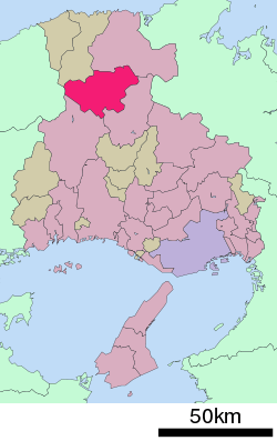
 Location of Yabu in Hyōgo Prefecture | ||
 Yabu Location in Japan | ||
| Coordinates: 35°24′N 134°46′E / 35.400°N 134.767°ECoordinates: 35°24′N 134°46′E / 35.400°N 134.767°E | ||
| Country | Japan | |
| Region | Kansai | |
| Prefecture | Hyōgo Prefecture | |
| Government | ||
| • Mayor | Kaoru Umetani | |
| Area | ||
| • Total | 422.70 km2 (163.21 sq mi) | |
| Population (February 29, 2012) | ||
| • Total | 26,879 | |
| • Density | 63.59/km2 (164.7/sq mi) | |
| Symbols | ||
| • Tree | Fagus crenata | |
| • Flower | Lysichiton camtschatcensis | |
| Time zone | Japan Standard Time (UTC+9) | |
| City hall address |
1675, Yoka, Yoka-chō, Yabu-shi, Hyōgo-ken 667-8651 | |
| Website |
www | |
Yabu (養父市 Yabu-shi) is a city located in Hyōgo Prefecture, Japan.
As of February 29, 2012, the city has an estimate population of 26,879 people, with 9,761 households, and a population density of 63.59 persons per km². The total area is 422.70 km².
The modern city of Yabu was established on April 1, 2004, from the merger of the former town of Yabu, absorbing the towns of Oya, Sekinomiya and Yoka (all from Yabu District).

Mt.Hyonosen, Hyonosen International Ski resort
External links
 Media related to Yabu, Hyōgo at Wikimedia Commons
- Yabu official website (Japanese)
This article is issued from Wikipedia - version of the 11/6/2015. The text is available under the Creative Commons Attribution/Share Alike but additional terms may apply for the media files.