Wittemoor timber trackway


The Wittemoor timber trackway is a log causeway or corduroy road across a bog at Neuenhuntdorf, part of the Berne in the district of Wesermarsch in Lower Saxony, Germany. Originating in the pre-Roman Iron Age, it is one of several such causeways which have been found in the North German Plain, particularly in the Weser-Ems region. It was excavated in 1965 and 1970 and prehistoric wooden cult figurines were discovered in association with it. It is trackway number XLII (IP).
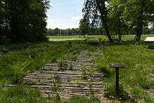
The trackway runs north-south and has been dated by dendrochronology to 135 BCE. It ran across the Wittemoor bog, connecting the more elevated geest at Hude with the River Hunte. An Iron Age settlement near a spring in the Lintel section of Hude was at the southern end. A section of the trackway has been reconstructed.
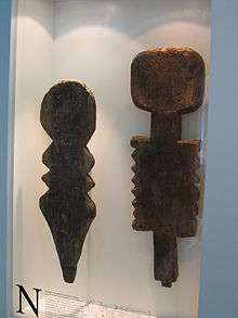
Six abstract wooden figurines were found during excavation of the trackway. The first were faceless male and female stelae, among the few Iron Age carvings to be preserved. Carved in silhouette out of oak planks 3 to 7 centimetres (1.2 to 2.8 in) thick, they are highly stylised, the male about 105 centimetres (41 in) tall with a rectangular body, the female about 95 centimetres (37 in) tall with breasts or shoulders indicated by a slanted cut, broad hips and vulva. They stood on either side of the trackway at the point where it crosses a stream, the male figure slotted into a plank, the female on a small mound. Fire sites also on either side of the track, one at each end of the crossing, and stones and worked alder sticks around two simple cult poles immediately north of the female figure suggest that offerings were made there.[1][2] The figurines had all been laid flat, which it has been suggested was to prevent desecration.[3] There was also a pole archway over the trackway between the two figures and the crossing.[4][5] The figures are thought to have had an apotropaic (protective) function,[4] although aesthetic decoration has also been suggested as an additional function.[6] The other four poles, one of which was hatchet-shaped,[4] were at damaged locations in the causeway, and may have been either warning markers or cult objects.
References
- ↑ Francesco Menotti, Wetland Archaeology and Beyond: Theory and Practice, Oxford: Oxford University, 2012, ISBN 9780199571017, p. 168.
- ↑ "Trackways and Ritual Deposition", The Oxford Handbook of Wetland Archaeology, ed. Francesco Menotti and Aidan O'Sullivan, Oxford: Oxford University, 2013, ISBN 9780199573493, p. 369, Fig. 21.3, p. 370.
- ↑ Johannes Maringer, "Das Wasser in Kult und Glauben der vorgeschichtlichen Menschen", Anthropos 68.5/6 (1973) 705–76, p. 745 (German); the suggestion was made by Hajo Hayen in the 1971 publication of the investigation.
- 1 2 3 Günter Behm-Blancke, "Materielle und geistige Kultur. Stammesgebiete im 1. und 2. Jahrhundert: Kult und Ideologie", in Bruno Krüger, et al., ed., Die Germanen: Geschichte und Kultur der germanischen Stämme in Mitteleuropa. Ein Handbuch in zwei Bänden, Volume 1 Von den Anfängen bis zum 2. Jahrhundert unserer Zeitrechnung, Veröffentlichungen des Zentralinstituts für Alte Geschichte und Archäologie der Akademie der Wissenschaften der DDR 4, Berlin: Akademie, 1976, OCLC 256529450, pp. 351–71, pp. 371, 373, Figs. 101, 102, p. 372 (German)
- ↑ Menotti, p. 193.
- ↑ Heiko Steuer, "Über anthropomorphe Moorpfähle der vorrömischen Eisenzeit", in Studien zur Lebenswelt der Eisenzeit: Festschrift für Rosemarie Müller, ed. Wolf-Rüdiger Teegen, Rosemarie Müller, Rosemarie Cordie, Olaf Dörrer and Heiko Steuer, Reallexikon der Germanischen Altertumskunde, Ergänzungsband 53, Berlin / New York: de Gruyter, 2006, ISBN 978-3-11-019010-6 (German)
Further reading
- Hajo Hayen. "Hölzerne Kultfiguren am Bohlenweg XLII (IP) im Wittemoor (Gemeinde Berne, Landkreis Wesermarsch)". Die Kunde NF 22 (1971), ISSN 0342-0736, 88–123. (German)
- Torsten Capelle and Bernhard Maier, "Idole, Idolatrie", in Reallexikon der Germanischen Altertumskunde, 2nd ed., Volume 15, Berlin / New York: de Gruyter, 2000, ISBN 3-11-016649-6, pp. 325–30. (German)
External links
- Photograph and map at Panoramio
- Martin L. Wittemoor Bohlenweg XLII (Ip) at The Megalithic Portal
- Photographs at The Megalithic Portal
Coordinates: 53°07′17″N 8°23′42″E / 53.121281°N 8.394939°E