Wisk'achani (Sud Yungas)
This article is about the mountain in the Sud Yungas Province, La Paz Department, Bolivia. For other uses, see Wisk'achani.
| Wisk'achani | |
|---|---|
 Wisk'achani Location within Bolivia | |
| Highest point | |
| Elevation | 4,088 m (13,412 ft) [1] |
| Coordinates | 16°38′27″S 67°42′39″W / 16.64083°S 67.71083°WCoordinates: 16°38′27″S 67°42′39″W / 16.64083°S 67.71083°W |
| Geography | |
| Location |
Bolivia, La Paz Department, Sud Yungas Province |
| Parent range | Andes |
Wisk'achani (Aymara wisk'acha a rodent,[2] -ni a suffix to indicate ownership, "the one with the viscacha (or viscachas)", hispanicized spelling Viscachani) is a 4,088-metre (13,412 ft) high mountain in the eastern extensions of the Cordillera Real in the Andes of Bolivia. It is situated in the La Paz Department, Sud Yungas Province, Irupana Municipality. Wisk'achani lies west of the Illimani massif, northeast of Link'u Link'u.[1][3]
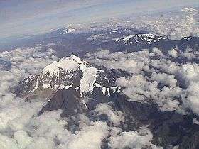
The Illimani massif with Link'u Link'u (center). Wisk'achani (on the right) is hidden by the clouds.
References
- 1 2 Bolivian IGM map 1:50,000 Lambate 6044-II
- ↑ Radio San Gabriel, "Instituto Radiofonico de Promoción Aymara" (IRPA) 1993, Republicado por Instituto de las Lenguas y Literaturas Andinas-Amazónicas (ILLLA-A) 2011, Transcripción del Vocabulario de la Lengua Aymara, P. Ludovico Bertonio 1612 (Spanish-Aymara-Aymara-Spanish dictionary)
- ↑ "Irupana". INE, Bolivia. Retrieved May 21, 2015.
This article is issued from Wikipedia - version of the 12/7/2015. The text is available under the Creative Commons Attribution/Share Alike but additional terms may apply for the media files.