Wisbech Canal
| Wisbech Canal | |
|---|---|
|
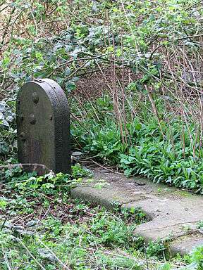
The remains of paddle gear and some stonework from Outwell flood lock | |
| Specifications | |
| Locks | 2 |
| Status | Infilled |
| History | |
| Original owner | Wisbech Canal Company |
| Date of act | 1794 |
| Date closed | 1926 |
| Geography | |
| Start point | Wisbech |
| End point | Outwell |
| Connects to | River Nene, Middle Level Navigations |
Wisbech Canal | ||||||||||||||||||||||||||||||||||||||||||||||||||||||||||||||||||||||||||||||||||||
|---|---|---|---|---|---|---|---|---|---|---|---|---|---|---|---|---|---|---|---|---|---|---|---|---|---|---|---|---|---|---|---|---|---|---|---|---|---|---|---|---|---|---|---|---|---|---|---|---|---|---|---|---|---|---|---|---|---|---|---|---|---|---|---|---|---|---|---|---|---|---|---|---|---|---|---|---|---|---|---|---|---|---|---|---|
| ||||||||||||||||||||||||||||||||||||||||||||||||||||||||||||||||||||||||||||||||||||
The Wisbech Canal was a broad canal near Wisbech in the Fenland area of Cambridgeshire, England. It ran from the River Nene at Wisbech to the Well Creek at Outwell in Norfolk, which gave access to the River Great Ouse. It was abandoned in 1926 and filled in during the 1970s.
History
The canal was planned as a means to improve the status of Wisbech as a trading centre. Following correspondence between the Hon and Revd Charles Lindsay, who later became chairman of the company, and Lord Hardwicke, on the potential benefits of the scheme, an engineer called John Watte was asked to prepare a survey and estimated costs. These were to be presented at a public meeting on 30 October 1792, but the meeting was swamped by speculators and traders from places as far away as Derby, Leicester, Uppingham, Huntingdon and Bedford. Some difficulty was experienced in maintaining control, but the local people succeeded in doing so, although the initial committee consisted of equal numbers of "strangers and people at home". A petition was presented to parliament on behalf of the burgesses of Wisbech in early 1794,[1] and the canal was authorised by an Act of Parliament (34 George III. Cap. 92) which was granted on 9 May 1794.[2]
This Act formed The Wisbech Canal Company, which had powers to raise £14,000, with an option to raise an additional £6,000 if required. This was to be used to construct the canal which ran from a junction with the River Nene at Wisbech, to a junction with the Well Creek and the Old River Nene at Outwell. The Well Creek connects to the Great Ouse. In addition, the company had powers to maintain and improve the river from Outwell Church to Salter's Lode Sluice on the Old River Nene. All traffic passing between the canal and the Nene River was required to pay a toll, which was to be used to maintain the Well Creek.[2]
Because of the low level of the Fens landscape, the canal was constructed on embankments for most of its 5.25 mile (8.4 km) length, and was opened in 1797. Flood locks were constructed at both ends of the canal.[2] The one at Outwell was 97 feet (30 m) long, but the one at Wisbech was only 50 feet (15 m), and so longer boats wishing to enter or leave the canal at the Wisbech end had to wait for the levels in the river and the canal to equalise, at which point both sets of gates could be opened. The canal did not have its own water supply, but was refilled when the water level in the Nene at Wisbech was high enough. This was normally only at spring tides, and so the water level often ran low in the period before the next spring tide was due.[3]
In 1883, the Wisbech and Upwell Tramway opened, running from Wisbech to Outwell and following a route along the course of the canal. It was extended to Upwell in 1884. Initially, there was some benefit to the canal, as coal was transported by the railway to Outwell, and loaded into boats by chutes. However, the railways steadily took the trade, and in 1914, the tolls collected only amounted to £56.[4] All traffic ceased in 1922,[5] and the canal was formally abandoned on 14 June 1926, when a warrant for its closure was obtained from the Minister of Transport.[6]
The canal remained in a derelict state until the early 1960s, when the Wisbech end was filled in to allow the A1101 Churchill Road link to be built without destroying the historic town centre.[7] Much of the rest of the canal was used as a landfill site, and consequently any development within 270 yd (250m) of the former line of the canal requires special consent from Cambridgeshire County Council's Waste Management Services department.[8]
See also
Points of interest
| Point | Coordinates (Links to map resources) |
OS Grid Ref | Notes |
|---|---|---|---|
| Wisbech lock | 52°40′01″N 0°09′43″E / 52.6670°N 0.1620°E | TF462098 | |
| Walsoken Bridge | 52°39′52″N 0°09′57″E / 52.6645°N 0.1659°E | TF465096 | |
| Elm Road Railway Bridge | 52°39′28″N 0°10′03″E / 52.6579°N 0.1675°E | TF466088 | |
| New Common Bridge | 52°39′17″N 0°10′08″E / 52.6547°N 0.1690°E | TF468085 | A1101 built over bed |
| Elm Bridge | 52°38′40″N 0°10′34″E / 52.6444°N 0.1761°E | TF473074 | |
| Collets Bridge | 52°38′06″N 0°11′28″E / 52.6349°N 0.1910°E | TF483063 | |
| Boyces Bridge | 52°37′33″N 0°12′44″E / 52.6257°N 0.2123°E | TF498054 | |
| Outwell Basin | 52°37′08″N 0°13′24″E / 52.6190°N 0.2233°E | TF506046 | |
| Scotts Bridge | 52°37′03″N 0°13′49″E / 52.6176°N 0.2302°E | TF510045 | |
| Outwell lock | 52°36′40″N 0°14′00″E / 52.6111°N 0.2332°E | TF513038 | Jn with Well Creek |
Bibliography
- Boyes, J; Russell, R (1977). The Canals of Eastern England. David and Charles. ISBN 978-0-7153-7415-3.
- Cumberlidge, Jane (1998). Inland Waterways of Great Britain (7th Ed.). Imray Laurie Norie and Wilson. ISBN 0-85288-355-2.
- Priestley, Joseph (1831). Historical Account of the Navigable Rivers, Canals and Railways of Great Britain.
- Russell, Ronald (1971). Lost Canals of England and Wales. David and Charles. ISBN 0-7153-5417-5.
