Wind atlas

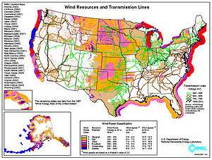
Map of available wind power for the United States. Color codes indicate wind power density class.
A wind atlas contains data on the wind speed and wind direction in a region. These data include maps, but also time series or frequency distributions. A climatological wind atlas covers hourly averages at a standard height (10 meter) over even longer periods (30 years). But depending on the application there are variations in averaging time, height and period.
Application
A wind atlas is employed when pre-selecting wind farm sites. The required data include 10-minute averaged wind at heights between 30 and 100 meter over a 10 to 20-year period.
Examples
At least one wind atlas covers the globe, and other wind atlases cover the EU12 countries and the European offshore regions. Wind atlases have also been compiled for many countries or regions.
External links
- Overview of wind atlases and wind surveys
- Global Wind Atlas
- World-wide wind atlas
- North Sea and Baltic
- Evaluation of global windpower
- Finnish Wind Atlas (Finnish Meteorological Institute)
- Dutch part of the North Sea
- Netherlands, 100 meter
- Netherlands, 10 meter
This article is issued from Wikipedia - version of the 10/5/2016. The text is available under the Creative Commons Attribution/Share Alike but additional terms may apply for the media files.