Whidbey Isles Conservation Park
| Whidbey Isles Conservation Park South Australia | |
|---|---|
|
IUCN category Ia (strict nature reserve) | |
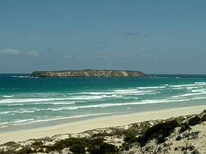
 Golden Island seen from Almonta Beach | |
 Whidbey Isles Conservation Park | |
| Nearest town or city | Coffin Bay. |
| Coordinates | 34°43′37.6″S 135°09′33″E / 34.727111°S 135.15917°ECoordinates: 34°43′37.6″S 135°09′33″E / 34.727111°S 135.15917°E |
| Established | 16 March 1967[1] |
| Area | 3.04 km2 (1.2 sq mi)[1] |
| Managing authorities | Department of Environment, Water and Natural Resources |
| See also | Protected areas of South Australia |
The Whidbey Isles Conservation Park consists of seven islands located west-southwest of Coffin Bay, lower Eyre Peninsula. The group, which includes the Four Hummocks group, Perforated Island, Price Island and Golden Island, supports breeding populations of seabirds and marine mammals. Colonies of the endangered Australian Sea-lion (Neophoca cinerea) and protected New Zealand Fur-seal (Arctocephalus forsteri) occur on some of these islands. The conservation park is classified as an IUCN Category Ia protected area.[2][3]
See also
References
- 1 2 "Protected Areas Information System - reserve list (as of 25 November 2014)" (PDF). Department of Environment Water and Natural Resources. Retrieved 8 January 2015.
- ↑ "Terrestrial Protected Areas of South Australia (see 'DETAIL' tab)". CAPAD 2012. Australian Government - Department of the Environment. 6 February 2014. Retrieved 6 February 2014.
- ↑ Anon (2006). Island Parks of Western Eyre Peninsula Management Plan (PDF). Adelaide: Department for Environment and Heritage (DEH), South Australia. p. 7. ISBN 1-921238-18-6.
External links
This article is issued from Wikipedia - version of the 4/5/2016. The text is available under the Creative Commons Attribution/Share Alike but additional terms may apply for the media files.