Westerwald Lakes
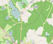
Map of the Westerwald Lake District
The Westerwald Lakes (German: Westerwälder Seen) lies within the eponymous Westerwald Lake District (Westerwälder Seenplatte) in the Westerwald forest within the town quarters of Hachenburg, Westerburg, Montabaur and Dierdorf in the German state of Rhineland-Palatinate. The lakes consist of seven ponds:
- Brinkenweiher
- Haidenweiher
- Hausweiher
- Hoffmannsweiher
- Postweiher
- Dreifelder Weiher (also Seeweiher)
- Wölferlinger Weiher
At 123 hectares, the Dreifelder Weiher is the largest.
References
External links
Coordinates: 50°34′51″N 7°50′19″E / 50.5809°N 7.8387°E
This article is issued from Wikipedia - version of the 7/18/2016. The text is available under the Creative Commons Attribution/Share Alike but additional terms may apply for the media files.