Wervin
| Wervin | |
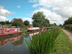
 Shropshire Union Canal Moorings near Wervin |
|
 Wervin |
|
| Population | 146 (2011 Census) |
|---|---|
| OS grid reference | SJ422719 |
| Civil parish | Wervin |
| Unitary authority | Cheshire West and Chester |
| Ceremonial county | Cheshire |
| Region | North West |
| Country | England |
| Sovereign state | United Kingdom |
| Post town | CHESTER |
| Postcode district | CH2 |
| Dialling code | 01244 |
| Police | Cheshire |
| Fire | Cheshire |
| Ambulance | North West |
| EU Parliament | North West England |
| UK Parliament | City of Chester |
Coordinates: 53°14′28″N 2°51′58″W / 53.241°N 2.866°W
Wervin is a small village and civil parish in the unitary authority of Cheshire West and Chester and the ceremonial county of Cheshire, England. It is situated between Chester and Ellesmere Port, near the Shropshire Union Canal and the M53 motorway. At the 2001 Census, Wervin had a population of 118,[1] increasing to 146 at the 2011 Census.[2]
The village was a township in St. Oswald's Parish of the Wirral Hundred, with a population of 56 in 1801, 60 in 1851, 94 in 1901 and 89 in 1951.[3]
See also
References
- ↑ 2001 Census: Wervin, Office for National Statistics, retrieved 18 November 2007
- ↑ "Parish population 2011". Retrieved 27 May 2015.
- ↑ Cheshire Towns & Parishes: Wervin, GENUKI UK & Ireland Genealogy, retrieved 7 November 2007
External links
![]() Media related to Wervin at Wikimedia Commons
Media related to Wervin at Wikimedia Commons
This article is issued from Wikipedia - version of the 12/6/2015. The text is available under the Creative Commons Attribution/Share Alike but additional terms may apply for the media files.