Washington State Route 532
| ||||
|---|---|---|---|---|
|
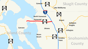
SR 532 highlighted in red. | ||||
| Route information | ||||
| Auxiliary route of I‑5 | ||||
| Defined by RCW 47.17.760 | ||||
| Maintained by WSDOT | ||||
| Length: | 10.09 mi[1] (16.24 km) | |||
| Existed: | 1964[2] – present | |||
| Major junctions | ||||
| West end: | Sunrise Boulevard in Camano | |||
| East end: |
| |||
| Highway system | ||||
| ||||
State Route 532 (SR 532) is a short Washington state highway in Island and Snohomish counties, located in the United States. The 10.09-mile (16.24 km) long roadway begins at Sunrise Boulevard in Camano and travels east through Stanwood to end at Interstate 5 (I-5). The road first appeared on a map in 1911 and in 1945 was designated Secondary State Highway 1Y (SSH 1Y), which became SR 532 in 1964. As of 2009, the Washington State Department of Transportation is improving the whole corridor from Camano to I-5 with repaving projects, new traffic cameras, new lanes and replacing the Mark Clark Bridge between Camano and Stanwood with the Gateway Bridge.[3]
Route description
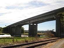
State Route 532 (SR 532) begins at an intersection with Sunrise Boulevard on Camano Island, which in turn is the census-designated place of Camano. From Sunrise Boulevard, the highway travels east through rural areas and a wetland to cross Davis Slough from Island County to Snohomish County. After entering Snohomish County, the roadway crosses the Stillaguamish River on the Gateway Bridge[3] and enters Stanwood. Between Sunrise Boulevard and the Stillaguamish River bridge, a daily average of 20,000 motorists used these sections of SR 532 in 2007, higher than the 3,500 that used the same stretch of road in 1970.[4][5] The route intersects city streets, crosses a railroad track owned by the BNSF Railway that serves Amtrak's Cascades route between Vancouver, British Columbia, and Seattle.[6][7] The tracks serve the Stanwood station, which was completed on November 12 and opened November 21, just north of SR 532.[8][9][10] After crossing the tracks, the roadway intersects the Pioneer Highway, which was SR 530 from 1964 until 1991.[11] The highway eventually leaves Stanwood and continues eastward past suburban housing areas and Sunday Lake to a diamond interchange with Interstate 5 (I-5).[12][13][14]
History

SR 532 first appeared on a map in 1911, which showed a road extending from Camano past East Stanwood (present-day Stanwood).[15] The state began maintaining the highway in 1945, when Secondary State Highway 1Y (SSH 1Y) was established, running along the current route of SR 532.[16] The Mark Clark Bridge, which is located on SR 532 between Camano Island and Stanwood, was constructed in 1949 and dedicated on July 23, 1950, to World War II general Mark Wayne Clark, who served out of Fort Lewis.[17] During the 1964 highway renumbering, SSH 1Y became SR 532;[2][18][19] since the 1964 renumbering, no major renumberings or route changes have been made. The Washington State Department of Transportation (WSDOT) arranged a minor project in 2007 and is currently working on a corridor improvement, a project designed to improve the highway from Camano to Interstate 5 (I-5).[20][21] During floods in January 2009, residents in Stanwood constructed a barrier to prevent water damage to the highway.[22] WSDOT is improving the whole corridor in a project divided into four miniature projects, all of which are expected to be complete by 2011.[20][23] The improvements include installing left-turn lanes and replacing the Mark Clark Bridge with a wider, four-lane bridge.[24][25] In 2001, when the project plans were underway, it was suggested that the roadway become five lanes wide and that a ferry from Everett to Camano Island be added;[26][27] WSDOT began seeking contractors in August 2008 and hired four by September.[28][29]
Major intersections
| County | Location | mi[1] | km | Destinations | Notes |
|---|---|---|---|---|---|
| Island | Camano | 0.00 | 0.00 | Sunrise Boulevard – Camano Island State Park Northeast Camano Drive – Camano Island State Park | Western terminus; roadway continues beyond Sunrise Boulevard as Camano Drive |
| Davis Slough | 2.91 | 4.68 | Bridge over Davis Slough | ||
| Snohomish | Stillaguamish River | 3.44 | 5.54 | Gateway Bridge[3] | |
| Stanwood | 5.25 | 8.45 | Pioneer Highway – Conway, Silvana | ||
| | 10.09 | 16.24 | Stanwood–Bryant Road – Bryant | Eastern terminus; roadway continues beyond I-5 as Stanwood–Bryant Road | |
| 1.000 mi = 1.609 km; 1.000 km = 0.621 mi | |||||
References
- 1 2 Washington State Department of Transportation (2006). "State Highway Log: Planning Report, SR 2 to SR 971" (PDF). Retrieved June 14, 2009.
- 1 2 Washington State Legislature. "RCW 47.17.760: State route No. 532". Retrieved June 14, 2009.
- 1 2 3 4 "Camano Gateway Bridge opens to traffic". Stanwood Camano News. Retrieved January 7, 2011.
- ↑ Washington State Department of Transportation (2007). "2007 Annual Traffic Report" (PDF). Retrieved June 14, 2009.
- ↑ Washington State Highway Commission, Department of Highways (1970). "Annual Traffic Report, 1970" (PDF). Washington State Department of Transportation. pp. 203–204. Retrieved June 14, 2009.
- ↑ Washington State Railroad System (PDF) (Map). Cartography by United States Geological Survey. Washington State Department of Transportation. September 2008. Retrieved June 14, 2009.
- ↑ Amtrak – Routes – Cascades (Map). Amtrak. 2009. Retrieved June 14, 2009.
- ↑ Pesznecker, Scott (April 21, 2008). "Stanwood to join Amtrak line". The Everett Herald. Retrieved June 14, 2009.
- ↑ Washington State Department of Transportation (2009). "Rail – Stanwood – New Station". Retrieved June 20, 2009.
- ↑ "WSDOT completes Stanwood Station project bringing passenger rail service back to community" (Press release). Washington State Department of Transportation. November 12, 2009. Retrieved November 17, 2009.
- ↑ Washington House of Representatives (1991). "Chapter 342, Laws of 1991: State Highway Routes – Revisons To (House Bill 5801)". Washington State Legislature. Retrieved June 14, 2009.
Beginning at a junction with state route number 5 ((
at Conway, thence southerly by way of Stanwood, thence southeasterly to a junction with state route number 5, thence easterly to a junction with state route number 9 at)) in the vicinity west of Arlington, thence easterly ((to)) and northerly by way of Darrington((, thence northerly)) to a junction with state route number 20 ((at)) in the vicinity of Rockport. - ↑ Google (June 14, 2009). "State Route 532" (Map). Google Maps. Google. Retrieved June 14, 2009.
- ↑ King, Pierce and Snohomish Counties Street Guide (Map). 1:24,000. Thomas Guide. Cartography by NAVTEQ. Rand McNally. 2008. pp. 294–296. § 294: 2A, 2B, 2C, 2D, 2E, 2F, 2G, 2H, 2I; 295: 2A, 2B, 2C, 3C, 3D, 3E, 3F, 3G, 3H, 3J; 296: 3A, 3B. ISBN 0-528-86671-0.
- ↑ Washington State Department of Transportation (January 21, 2009). "SR 5 – Exit 212; Junction SR 532 /" (PDF). Retrieved June 14, 2009.
- ↑ Mount Vernon (1911) (Map). 1:125,000. Washington 1:125,000 topographic quadrangles. Cartography by United States Geological Survey. Washington State University. 1911. Retrieved June 14, 2009.
- ↑ Washington State Legislature (March 16, 1945). "Chapter 248: Highways and Bridges Within State Parks". Session Laws of the State of Washington. Session Laws of the State of Washington (1945 ed.). Olympia, Washington: Washington State Legislature. p. 729. Retrieved June 14, 2009.
There is hereby established as a branch of Primary State Highway No. 1 a secondary state highway to be known and referred to as Secondary State Highway No. 1Y as follows: Beginning at a junction with Primary State highway No. 1 in the vicinity east of East Stanwood; thence in a westerly direction by the most feasible route to a junction with Secondary State Highway 1E in the vicinity of East Stanwood; thence in a westerly direction by the most feasible route by way of Stanwood and over a bridge to a point on Camano Island known as McEachern's Corner.
- ↑ Duane Colt Denfeld (May 1, 2009). "Clark, General Mark Wayne (1896–1984)". HistoryLink. Retrieved June 15, 2009.
- ↑ C. G. Prahl (December 1, 1965). "Identification of State Highways" (PDF). Washington State Highway Commission, Department of Highways. Retrieved June 14, 2009.
- ↑ United States Geological Survey (1966). Victoria, 1966 (Map). 1:250,000. University of Texas at Austin. Retrieved June 14, 2009.
- 1 2 Washington State Department of Transportation (2009). "SR 532 – Corridor Improvements". Retrieved June 14, 2009.
- ↑ Washington State Department of Transportation (2009). "Agency Projects: Completed Projects for SR 532". Retrieved July 21, 2009.
- ↑ Hefley, Diana; Manry, Kaitlin; Stevick, Eric; Smith, Debra; Fiege, Gale (January 9, 2009). "At least 500 county homes flooded, officials say". The Everett Herald. Retrieved June 14, 2009.
- ↑ Sheets, Bill (January 31, 2009). "Highway 532 fixes will help Stanwood, Camano Island residents get around". The Everett Herald. Retrieved June 14, 2009.
- ↑ Washington State Department of Transportation (2009). "SR 532 – Camano Island to I-5 Planned Projects". Retrieved June 14, 2009.
- ↑ SR 532 Corridor Improvements (Map). Cartography by Tele Atlas. Washington State Department of Transportation. 2006. Retrieved June 14, 2009.
- ↑ Kelly, Brian (June 26, 2001). "North county road projects to be aired". The Everett Herald. Retrieved June 14, 2009.
- ↑ Kelly, Brian (October 15, 2001). "5 lanes advised for Stanwood road". The Everett Herald. Retrieved June 14, 2009.
- ↑ "WSDOT reaches milestone in SR 532 project, begins search for design-build contractor" (Press release). Washington State Department of Transportation. August 1, 2008. Retrieved June 14, 2009.
- ↑ "WSDOT's search for SR 532's A-team continues: Applicant list narrowed to four design-builders" (Press release). Washington State Department of Transportation. September 29, 2008. Retrieved June 14, 2009.
External links
| Wikimedia Commons has media related to Washington State Route 532. |
- Highways of Washington State
- WSDOT Stanwood Area Traffic Cameras
- SR 532 Corridor Improvements
- WSDOT Projects
- Completed WSDOT Projects

