Warren Brick Streets
|
Warren Brick Streets | |
 | |
  | |
| Location | Portions of Cedar, Myrtle, Chestnut, 1st, Walnut, Elm and Cypress Sts., Warren, Arkansas |
|---|---|
| Coordinates | 33°36′52″N 92°3′45″W / 33.61444°N 92.06250°WCoordinates: 33°36′52″N 92°3′45″W / 33.61444°N 92.06250°W |
| Area | 4.5 acres (1.8 ha) |
| Built | 1927 |
| Part of | Warren Commercial Historic District (#16000433) |
| MPS | Arkansas Highway History and Architecture MPS |
| NRHP Reference # | 06001277[1] |
| Significant dates | |
| Added to NRHP | January 24, 2007 |
| Designated CP | July 11, 2016 |
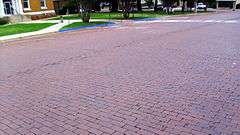
The Warren Brick Streets of Warren, Arkansas are a collection of city streets that have retained original brick pavement laid down in the late 1920s. The sections include blocks of Cedar, Myrtle, Chestnut, 1st, Walnut, Elm, and Cypress Streets, and include nearly 5,000 feet (1,500 m) of pavement. The bricks are laid out in a running bond pattern up to intersections, where a diamond pattern is used, partly to maintain the position of the bricks. The bricks measure 4 by 8.5 inches, and are probably 2 inches thick. The streets are 36 feet (11 m) wide, with 2 feet of concrete gutter and curbing. It is surmised that the bricks were laid on a concrete substrate, in part because the condition of the surviving sections is very good.[2]
The street sections were listed on the National Register of Historic Places in 2007.[1]
See also
References
- 1 2 National Park Service (2010-07-09). "National Register Information System". National Register of Historic Places. National Park Service.
- ↑ "NRHP nomination for Warren Brick Streets" (PDF). Arkansas Preservation. Retrieved 2014-01-04.
| Topics | |
|---|---|
| Lists by states |
|
| Lists by insular areas | |
| Lists by associated states | |
| Other areas | |
| |