Wadi Hawran
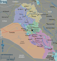
Wādī Ḩawrān, also known as وادي حوران is a wadi in Al Anbār, west Iraq.[1][2] Located at Latitude33.0333°, Longitude40.2500° Wādī Ḩawrān is roughly midway between Damascus and Baghdad near the town of Rutba, Iraq. The landscape in this part of the Iraq desert is undulating and barren. The wadi flows from near the Jordanian border and traverses east through the Iraq desert till it meets the Euphrates near the town of Alaleya.[3] The wadi collects water from an area encompassing most of Anbar province,[4] and is at an elevation of 83 meters.[5] The wadi was mentioned by Yaqut al-Hamawi[6] and possibly Al Tabari[7] and was traditionally the territory of the al-Qayn tribes. In the 19th century many Druze fleeing persecution entered the western part of the catchment, and in the 1870s the wadi was captured by Jabal Shammar.[8] On 27 March 1917 British forces captured 2,000 Turkish troops at the wadi.[9] Then in 2007 the bridge over the wadi was destroyed by a improvised explosive device.[10]
References
- ↑ Hawran Wadi at getamap.net.
- ↑ Wadi Hawran at allaboutcountries.com.
- ↑ Satelyte view.
- ↑ map at mapcarta.com.
- ↑ satelliteview of WadiHawran.
- ↑ Fred M. Donner, The Early Islamic Conquests(Princeton University Press, 2014) page 312.
- ↑ History of al-Tabari Vol. 11, page 63.
- ↑ Alexei Vassiliev, The History of Saudi Arabia (Saqi, 2013).
- ↑ David Burg, Almanac of World War I (University Press of Kentucky, 2010).
- ↑ www.2ndmardiv.marines.mil/News.