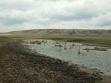
Velykyi Kuyalnik River
Coordinates: 46°47′52″N 30°35′33″E / 46.79778°N 30.59250°E
| Velykyi Kuyalnik River | |
|---|---|
 The lower course | |
| Country | Ukraine |
| Basin | |
| River mouth | Kuyalnik Estuary |
| Basin size | 1,860 km2 (720 sq mi)[1] |
| Physical characteristics | |
| Length | 150 km (93 mi)[1] |
The Velykyi Kuyalnik (Ukrainian: Великий Куяльник), or Bolshoy Kuyalnik (Russian: Большой Куяльник) is a river in Podilsk, Ananyiv, Shyriaievee, and Ivanivka Raions of Odessa Oblast in Ukraine. Its mouth is the Kuyalnik Estuary of the Black Sea. The length of the river is 150 kilometres (93 mi), and the area of its drainage basin is 1,860 square kilometres (720 sq mi).[1] The urban-type settlements of Shyriaieve and Ivanivka are located on the banks of the Velykyi Kuyalnik.
In the past, the Velykyi Kuyalnik was navigable and, together with the Dniester, was used to transport goods to the Black Sea, bypassing the cascades at the Dnieper River. In 2007-2008, illegal sand diggers built a damb in the mouth of the Velykyi Kuyalnik, so that the river does not empty to the sea anymore. The damb has never been demolished, leading to drying out of the estuary.[2][3]
References
- 1 2 3 "Большой Куяльник" (in Russian). Great Soviet Encyclopedia. Retrieved 21 May 2016.
- ↑ "Куяльник: туманное будущее национального парка" (in Russian). Таймер. 28 June 2010. Retrieved 21 May 2016.
- ↑ Симоненко, Ольга. "Куяльник погибает: одесское «Мертвое море» обмелело" (in Russian). Odessa-life. Retrieved 21 May 2016.