Tuttlingen (district)
| Tuttlingen | |
|---|---|
| District | |
 | |
| Country |
|
| State | Baden-Württemberg |
| Adm. region | Freiburg |
| Capital | Tuttlingen |
| Area | |
| • Total | 734.4 km2 (283.6 sq mi) |
| Population (31 December 2015)[1] | |
| • Total | 136,606 |
| • Density | 190/km2 (480/sq mi) |
| Time zone | CET (UTC+1) |
| • Summer (DST) | CEST (UTC+2) |
| Vehicle registration | TUT |
| Website | http://www.landkreis-Tuttlingen.de |

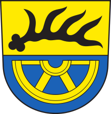
Coat of arms
Tuttlingen is a county (Kreis) in the south of Baden-Württemberg, Germany. Neighboring counties are (from north clockwise) Rottweil, Zollernalbkreis, Sigmaringen, Constance and Schwarzwald-Baar.
History
The county dates back to the Oberamt Tuttlingen, which was created in 1806. After several minor changes it was merged with the Oberamt Spaichingen and converted into the county in 1938. In 1973 it was enlarged by some municipalities from the dissolved counties Donaueschingen and Stockach.
Geography
The landscape of the county are the hills of the Swabian Alb, with the Danube as the main river.
Coat of arms
| The coat of arms show a deer antler in the top part, the symbol of the state of Württemberg. The area of the district became part of Württemberg in the 14th century. The half wheel in the bottom is the symbol of the Lords of Hohenberg, representing an Austrian possession in the district. |
Towns and municipalities
| Towns | Municipalities | |
|---|---|---|
|
||
| Verwaltungsgemeinschaften | ||
|
References
External links
| Wikimedia Commons has media related to Landkreis Tuttlingen. |
- Official website (German)
Coordinates: 48°00′N 8°48′E / 48°N 8.8°E
This article is issued from Wikipedia - version of the 6/22/2015. The text is available under the Creative Commons Attribution/Share Alike but additional terms may apply for the media files.