Tropical Storm Aletta (2006)
| Tropical storm (SSHWS/NWS) | |
.jpg) Tropical Storm Aletta | |
| Formed | May 27, 2006 |
|---|---|
| Dissipated | May 30, 2006 |
| Highest winds |
1-minute sustained: 45 mph (75 km/h) |
| Lowest pressure | 1002 mbar (hPa); 29.59 inHg |
| Fatalities | None |
| Damage | Minimal |
| Areas affected | Mexico |
| Part of the 2006 Pacific hurricane season | |
Hurricane Fabian
| Category 4 hurricane (SSHWS) | |||
|---|---|---|---|
| |||
| Duration | 6 September – October 1 | ||
| Peak intensity | 140 mph (230 km/h) (1-min) 1009 mbar (hPa) | ||
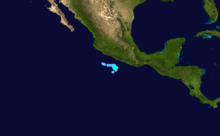
Tropical Storm Aletta was the first tropical cyclone of the 2006 Pacific hurricane season. Aletta developed from an area of disturbed weather located south-southwest of the Mexican port of Acapulco, Guerrero. It gradually gained organized convection and was classified as a tropical depression early on May 27, and became a tropical storm later that morning, the first of 2006 in the Western Hemisphere. Aletta strengthened to a tropical storm with 45 mph (75 km/h) sustained winds, while moving towards the Guerrero coast in southwestern Mexico. The storm became stationary, though it later turned to the west and weakened on May 29. Aletta continued to weaken until it dissipated on May 31. The storm dropped moderate rainfall along the Mexican coast, and generated winds that downed trees and caused minor damage.
Meteorological history

On May 21, 2006, a tropical wave crossed Central America and entered the East Pacific. The wave drifted westward, and after several days began to interact with a low-level trough near the Gulf of Tehuantepec, and as a result deep convection increased. By May 25, a large area of low pressure formed several hundred miles south of Acapulco, Mexico. Wind shear inhibited development initially, though conditions became slightly more favorable after a number of days, and at 0600 UTC on May 27, a tropical depression formed about 190 mi (305 km) south of Acapulco.[1]
Moving very little, the depression was disorganized due to continued shear, leaving the center of circulation west of the convective activity.[2] By later in the morning hours of May 27, the system began to show overall signs of organization, primarily related to a burst of convection in the eastern semicircle. At the same time, the center of circulation either reformed or began to move farther north, possibly north-northeast. Embedded within the steering currents of a ridge, most forecasts anticipated the storm would drift northward for several days, though some computer models predicted the storm would eventually move inland near Acapulco.[3] At 1800 UTC on May 27, the depression organized into a tropical storm, and as such was named Aletta by the National Hurricane Center.[1]
With continued forecasting difficulty,[4] a burst of new convection formed east of the center early on May 28, as the storm began meandering southward.[5] At 0600 UTC, Aletta attained peak winds of 45 mph (72 km/h) while nearly stationary in forward movement.[1] Later in the afternoon, the storm's center was obscured, thus subjecting the exact location to speculation. In addition, the circulation fluctuated in organization with the alternating intensity of the wind shear, and at the time maintained elongated cloud patterns, rather than the typical circulatory shape.[6] As the storm drifted to the west and executed a small cyclonic loop by early on May 29, increased shear and dry air became entrained in the system, causing it to weaken to a tropical depression at 1800 UTC.[1] Little convection remained afterward,[7] and the storm struggled for several days, becoming a remnant low by May 31. The low dissipated shortly thereafter.[1]
Preparations and impact
When the storm began to move towards the coast, the Mexican government issued tropical storm watches between Punta Maldonado and Zihuatanejo.[8] By 1800 UTC on May 29, the advisory was discontinued after a series of modifications and extensions.[1]
Aletta produced moderate rainfall across Mexico, including a 24-hour rainfall total of 100.2 mm (3.94 inches) in Jacatepec, Oaxaca on May 30, and 96.0 mm (3.78 inches) in La Calera, Guerrero, the next day.[8] High winds knocked down trees and caused minor structural damage. In Zihuatanejo, a ship with nine people was rescued after being reported as lost, which may have been a result of high seas generated by Aletta.[9] However, there were no reports of fatalities associated with Aletta.[1]
See also
- List of Pacific hurricanes
- Other tropical cyclones named Aletta
- Timeline of the 2006 Pacific hurricane season
- List of storms in the 2006 Pacific hurricane season
References
- 1 2 3 4 5 6 7 Richard J. Pasch (2006). "Tropical Storm Aletta Tropical Cyclone Report" (PDF). National Hurricane Center. Retrieved 2008-09-02.
- ↑ Avila (2006). "Tropical Depression One Discussion Number 1". National Hurricane Center. Retrieved 2008-09-02.
- ↑ Stewart (2006). "Tropical Depression One Discussion Number 2". National Hurricane Center. Retrieved 2008-09-02.
- ↑ Pasch (2006). "Tropical Storm Aletta Discussion Number 4". National Hurricane Center. Retrieved 2008-09-02.
- ↑ Stewart (2006). "Tropical Storm Aletta Discussion Number 5". National Hurricane Center. Retrieved 2008-09-02.
- ↑ Franklin (2006). "Tropical Storm Aletta Discussion Number 7". National Hurricane Center. Retrieved 2008-09-02.
- ↑ Pasch (2006). "Tropical Depression Aletta Discussion Number 12". National Hurricane Center. Retrieved 2008-09-02.
- 1 2 Alberto Hernández Unzón; M. G. Cirilo Bravo Lujano. "Resúmen de la Tormenta Tropical Aletta del Océano Pacífico" (PDF) (in Spanish). Servicio Meteorologico Nacional, Comisión Nacional del Agua. Archived from the original (PDF) on September 21, 2006. Retrieved 2006-09-09.
- ↑ Staff Writer (2006). "Afecta tormenta Aletta a Guerrero" (in Spanish). El Siglo De Torreon. Retrieved 2008-09-02.


