Toamasina Province
| Toamasina | |
|---|---|
| Province | |
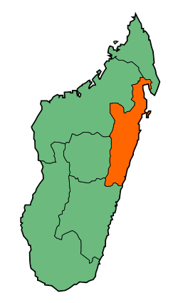
 Map of Madagascar with Toamasina highlighted | |
| Coordinates (Capital): 17°45′S 48°45′E / 17.750°S 48.750°ECoordinates: 17°45′S 48°45′E / 17.750°S 48.750°E | |
| Country |
|
| Capital | Toamasina |
| Area | |
| • Total | 71,911 km2 (27,765 sq mi) |
| Population (2004) | |
| • Total | 2,855,600 |
| • Density | 40/km2 (100/sq mi) |
| Time zone | UTC+3 |
The Toamasina Province is a former province of Madagascar with an area of 71,911 km². It had a population of 2,855,600 (2004). Its capital was Toamasina, the most important seaport of the country. The province was also known as Tamatave Province.[1]
Except for Toliara, Toamasina Province bordered all of the country's other provinces; Antsiranana in the north, Mahajanga in the northwest, Antananarivo in the southwest and Fianarantsoa in the south. Northern Betsimisaraka Malagasy and Southern Betsimisaraka Malagasy languages were widely spoken.[2]
Despite the production of exportable crops the people inhabiting the rural regions of the province were mostly poor. In terms of rural poverty the province was only better than the Toliara province. In urban areas the condition was comparatively better and the percentage of people living below the poverty line was the least in the whole of Madagascar. The country's largest harbour–Toamasina Harbour was located in the province.[3] Vanilla farming was also an important activity.[4]
In 2002 a state of emergency was declared by the then president Didier Ratsiraka after his rival Marc Ravalomanana announced that he had won the majority in the presidential elections held in December 2001. Major politicians of the provinces favouring Ratsiraka as the president met in Toamasina where they announced the creation of a new republic that would have excluded the landlocked Antananarivo Province. Toamasina favoured Ratsiraka as the president. Political tension prompted ethnic clashes and in the coastal provinces the Merina people were subject to attacks. Murders of people belonging to the Merina community were also reported. Peace was restored only when Ravalomanana was installed the country's president and Ratsiraka left the country.[5]
Lake Rasoabe and Ranomainty were located in the province.[6] The coastal areas of the province were covered with dense rain forests and the province had a rich variety of flora and fauna.[7][8] Lemurs were also found.[9]
Abolition
The provinces were abolished following the results of Malagasy constitutional referendum, 2007 which led to the formation of 22 smaller areas (faritra or regions) to facilitate regional development.[10]
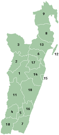
Administrative divisions

- Alaotra-Mangoro region
- 1. Ambatondrazaka District (Ambatondrazaka)
- 2. Amparafaravola District (Amparafaravola)
- 3. Andilamena District (Andilamena)
- 4. Anosibe An'ala District (Anosibe An'ala)
- 11. Moramanga District (Moramanga)
- Analanjirofo region
- 6. Fenerive Est District (Fenerive Est, Fenoarivo Atsinanana)
- 8. Mananara Nord District (Mananara Nord, Mananara Avaratra)
- 9. Maroantsetra District (Maroantsetra)
- 12. Nosy-Boraha District (Nosy-Boraha, Île Sainte-Marie)
- 13. Soanierana Ivongo District (Soanierana Ivongo)
- 17. Vavatenina District (Vavatenina)
- Atsinanana region
- 5. Antanambao Manampotsy District (Antanambao Manampotsy)
- 7. Mahanoro District (Mahanoro)
- 10. Marolambo District (Marolambo)
- 14. Toamasina II District (Toamasina II)
- 15. Toamasina District (Toamasina)
- 16. Vatomandry District (Vatomandry)
- 18. Vohibinany District (Vohibinany, Ampasimanolotra, Brickaville)
References
- ↑ Banerjee, Sudipto; Carlin, Bradley P.; Gelfand, Alan E. (2003). Hierarchical Modeling and Analysis for Spatial Data. CRC Press. p. 200. ISBN 978-0-203-48780-8.
- ↑ Frawley, William (2003). International Encyclopedia of Linguistics. Oxford University Press. p. 205. ISBN 978-0-19-513977-8.
- ↑ International Monetary Fund (1997). Madagascar - Recent Economic Developments and Selected Issues. International Monetary Fund. p. 47. ISBN 978-1-4519-9201-4.
- ↑ Cadot, Olivier; Dutoit, Laure; Melo, Jaime De (2006). The Elimination of Madagascar's Vanilla Marketing Board, Ten Years on. World Bank Publications. p. 9. GGKEY:A6SDJTFR381.
- ↑ Nielssen, Hilde (2011). Ritual Imagination: A Study of Tromba Possession Among the Betsimisaraka in Eastern Madagascar. BRILL. p. 260. ISBN 90-04-21524-7.
- ↑ Campbell, Gwyn (2012). David Griffiths and the Missionary "History of Madagascar". BRILL. p. 486. ISBN 978-90-04-19518-9.
- ↑ Bruce, Nile (2008). Advances in the Taxonomy and Biogeography of Crustacea in the Southern Hemisphere. PenSoft Publishers LTD. p. 81. ISBN 978-954-642-505-8.
- ↑ Wickens, Gerald E.; Lowe, Pat (2008). The Baobabs: Pachycauls of Africa, Madagascar and Australia: The Pachycauls of Africa, Madagascar and Australia. Springer Science & Business Media. p. 271. ISBN 978-1-4020-6431-9.
- ↑ Gould, Lisa; Sauther, M.L. (2006). Lemurs: Ecology and Adaptation. Springer Science & Business Media. p. 181. ISBN 978-0-387-34586-4.
- ↑ "Initial result shows "Yes" to revision of constitution in Madagascar". People's Daily Online. 7 April 2007. Retrieved 20 September 2014.